- Wattle Range Council
-
Wattle Range Council
South Australia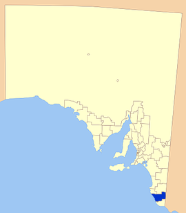
Position of the Wattle Range CouncilPopulation: 12,554(2009)[1] Established: 1997 Coordinates: 37°27′55″S 140°30′00″E / 37.4653°S 140.4999°ECoordinates: 37°27′55″S 140°30′00″E / 37.4653°S 140.4999°E Area: 3923.5 km² (1,514.9 sq mi) Mayor: Mark Braes Council Seat: Millicent Region: Limestone Coast State District: MacKillop, Mount Gambier Federal Division: Barker 
LGAs around Wattle Range Council: District Council of Robe Naracoorte Lucindale Council Wattle Range Council Glenelg (Vic) District Council of Grant Wattle Range Council is a local government area in the Limestone Coast region of south eastern South Australia. It stretches from the coast at Beachport east to the Victorian border. The estimated population of the council area is about 12,554 people.[1]
The council is divided into four wards; Kintore, Riddoch, Sorby Adams and Corcoran wards, with two or more councillors representing each ward.
Contents
History
The aboriginal people of the region were composed of five powerful tribes, each occupying its own territory which was strictly defined, and territorial rights guarded jealously. Each had different dialects and the names of the tribes were Booandik, Pinegunga, Mootatunga, Wichitunga and Polingunga, of which the first was the most powerful.[2] The tract of country occupied by the Booandik extended from the mouth of the Glenelg River to Rivoli Bay North (Beachport) for about 30 miles inland.
European settlers first moved into the area in the late 1840s, and by the 1860s opened up tracts of land for farming cereal crops. Beachport became an important port during the 1880s, further increasing the population of the area.[2] The first local government areas were setup around the three towns of Millicent, Penola and Beachport in the late 19th century, with each operating independently of each other until 1997.
The Wattle Range Council was formed in 1997 from the amalgamation of the District Councils of Beachport, Millicent and Penola.[3]
Economy
The local economy is dependent on wide range of activities, with agriculture, fishing, forestry and tourism making up the major components.
Sheep and cattle farming are the prominent agricultural venture, with dairy farming common also. Cereal cropping is also prevalent in the nutrient rich soils of the South East.[4]
Viticulture is well established in the council area, with one of South Australia's premier wine growing regions, the Coonawarra, located in its bounds, with rich terra rossa soil aiding the wine quality.[5]
Forestry and milling have also been important to the district, with processing plants at Nangwarry and Millicent.
Tourism is a diverse, growing aspect of the economy, with seaside towns such as Beachport attracting tourists for the seaside atmosphere, and others such as Coonawarra, for the wine growing industry.[6]
Localities
The service town of the district is Millicent, with a large number of other towns and localities encompassed in the council area. The full list is:
Beachport, Benara, Benara Flat, Canunda, Comaum, Coonawarra, Furner, Glencoe, Glencoe West, Glenroy, Grey, Hatherleigh, Kalangadoo, Katnook, Killanoola, Kirip, Koorine, Krongart, Leggs Lane, Maaoupe, Millicent, Mount Burr, Mount Graham, Mount McIntyre, Nangula, Nangwarry, Penola, Pompoon, Rendlesham, Rivoli Bay, Rocky Camp, Sebastapol, Short, Snuggery, Southend, St Clair, Tantanoola, Thornlea, Wattle Range and Wyrie[7]
Elected Members
Mayor: Mark Braes
CEO: Frank Brennan
Councillor and Ward:
- Rosemary Kain - Kintore
- Michael McCourt - Kintore
- Peter Muller - Riddoch
- Vivian Reschke - Riddoch
- Glenn Brown - Corcoran
- Sharon Cox - Corcoran
- Gwenda Lawlor - Corcoran
- Darren O'Halloran - Corcoran
- Jennifer Osis - Corcoran
- Peter Dunnicliff - Sorby Adams
- Robert Dycer - Sorby Adams
References
- ^ a b Australian Bureau of Statistics (30 March 2010). "Regional Population Growth, Australia, 2008–09". http://www.abs.gov.au/ausstats/abs@.nsf/Latestproducts/3218.0Main%20Features72008-09?opendocument&tabname=Summary&prodno=3218.0&issue=2008-09&num=&view=. Retrieved 3 June 2010.
- ^ a b Manning Index, South East, http://www.slsa.sa.gov.au/manning/pn/s/stheast.htm, retrieved 2007-06-18
- ^ Wattle Range Council, Home, archived from the original on 2007-08-28, http://web.archive.org/web/20070828232203/http://www.wattlerange.sa.gov.au/site/page.cfm?u=100, retrieved 2007-06-18[dead link]
- ^ Wattle Range Council, Primary Industries, archived from the original on 2007-08-11, http://web.archive.org/web/20070811002900/http://www.wattlerange.sa.gov.au/site/page.cfm?u=137, retrieved 2007-06-18[dead link]
- ^ WineDiva, Coonawarra region, http://www.winediva.com.au/regions/coonawarra.asp, retrieved 2007-06-18
- ^ Wattle Range Tourism, Home, http://www.wattlerange.sa.gov.au/site/page.cfm?u=299, retrieved 2007-06-18
- ^ LGA of South Australia, Wattle Range Council, http://www.lga.sa.gov.au/site/page.cfm?c=4198, retrieved 2007-06-18
External links
Local Government Areas of South Australia Metropolitan Adelaide Adelaide · Adelaide Hills · Burnside · Campbelltown · Charles Sturt · Gawler · Holdfast Bay · Marion · Mitcham · Norwood Payneham & St Peters · Onkaparinga · Playford · Port Adelaide Enfield · Prospect · Salisbury · Tea Tree Gully · Unley · Walkerville · West TorrensEyre Peninsula Ceduna · Cleve · Elliston · Franklin Harbour · Kimba · Lower Eyre Peninsula · Port Augusta · Port Lincoln · Streaky Bay · Tumby Bay · Wudinna · WhyallaCentral Barossa · Barunga West · Clare and Gilbert Valleys · Copper Coast · Flinders Ranges · Goyder · Light · Mallala · Mount Remarkable · Northern Areas · Orroroo Carieton · Peterborough · Port Pirie · Wakefield · Yorke PeninsulaSouthern and Hills Murray Mallee Southeast Outback Categories:- Populated places established in 1997
- 1997 establishments in Australia
- Local Government Areas of South Australia
- Limestone Coast

Wikimedia Foundation. 2010.