- City of Port Augusta
-
City of Port Augusta
South Australia
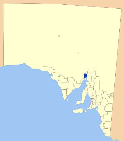
Location of the City of Port AugustaPopulation: 14,669(2009)[1] • Density: 11.72/km² (30.4/sq mi) Established: 1964 Area: 1153.1 km² (445.2 sq mi) Mayor: Nancy Baluch Council Seat: Port Augusta Region: Upper Spencer Gulf State District: Stuart Federal Division: Grey 
LGAs around City of Port Augusta: Outback Areas Community Development Trust Flinders Ranges Council City of Port Augusta District Council of Mount Remarkable City of Whyalla The City of Port Augusta is a local government area located at the northern end of Spencer Gulf in South Australia. It is centred on the town of Port Augusta. The city is the site of South Australia's main power supplier, the Port Augusta powerhouse, located on the coast in Spencer Gulf.
Contents
History
The Port Augusta region is a natural crossroads and aborigines have been trading in the area for 40 000 years. European settlement began in the 1840s and the town grew from a pastoral service centre to a railway town with the construction of the overland telegraph line, then the commencement of the railways towards Alice Springs and Kalgoorlie.
In late 1964, Port Augusta was granted City status, and the current council was formed.
Another major industry now is the production of electric power, with three coal-fired power stations burning coal mined at Leigh Creek, the first of which was completed in 1954.
Localities
The district also includes two closely neighbouring areas, one of which is a significant town. This means there are two towns in the district:
- Port Augusta
- Stirling North
- Miranda - a small coastal area south of Port Augusta, but basically uninhabited.
Elected Members
Mayor: Nancy Baluch
CEO: Greg Perkin
Councillors:
- Sam Johnson
- Lisa Lumsden
- Ken McKlean
- Peter Solomon
- Tony Mitchell
- Phil Brown
- Fran Paynter
- Brett Benbow
- Phil Greagen
The city council area is bordered to the north and west by non-council areas administered by the Outback Areas Community Development Trust. To the south west by the City of Whyalla, and to the east by Flinders Ranges Council and District Council of Mount Remarkable.
References
- ^ Australian Bureau of Statistics (30 March 2010). "Regional Population Growth, Australia, 2008–09". http://www.abs.gov.au/ausstats/abs@.nsf/Latestproducts/3218.0Main%20Features72008-09?opendocument&tabname=Summary&prodno=3218.0&issue=2008-09&num=&view=. Retrieved 4 June 2010.
External links
References
- ^ Australian Bureau of Statistics (30 March 2010). "Regional Population Growth, Australia, 2008–09". http://www.abs.gov.au/ausstats/abs@.nsf/Latestproducts/3218.0Main%20Features72008-09?opendocument&tabname=Summary&prodno=3218.0&issue=2008-09&num=&view=. Retrieved 4 June 2010.
Coordinates: 32°29′30″S 137°45′44″E / 32.4916666667°S 137.762222222°E
Local Government Areas of South Australia Metropolitan Adelaide Adelaide · Adelaide Hills · Burnside · Campbelltown · Charles Sturt · Gawler · Holdfast Bay · Marion · Mitcham · Norwood Payneham & St Peters · Onkaparinga · Playford · Port Adelaide Enfield · Prospect · Salisbury · Tea Tree Gully · Unley · Walkerville · West TorrensEyre Peninsula Ceduna · Cleve · Elliston · Franklin Harbour · Kimba · Lower Eyre Peninsula · Port Augusta · Port Lincoln · Streaky Bay · Tumby Bay · Wudinna · WhyallaCentral Barossa · Barunga West · Clare and Gilbert Valleys · Copper Coast · Flinders Ranges · Goyder · Light · Mallala · Mount Remarkable · Northern Areas · Orroroo Carieton · Peterborough · Port Pirie · Wakefield · Yorke PeninsulaSouthern and Hills Murray Mallee Southeast Outback Suburbs and localities of the City of Port Augusta Categories:- Populated places established in 1964
- 1964 establishments in Australia
- Local Government Areas of South Australia
- Eyre Peninsula
Wikimedia Foundation. 2010.