- District Council of Robe
-
District Council of Robe
South Australia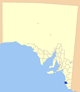
Location of the District Council of Robe in bluePopulation: 1,480(2009)[1] Established: 1869 Area: 1091.1 km² (421.3 sq mi) Mayor: Wiliam Peden Council Seat: Robe Region: Limestone Coast State District: MacKillop Federal Division: Barker 
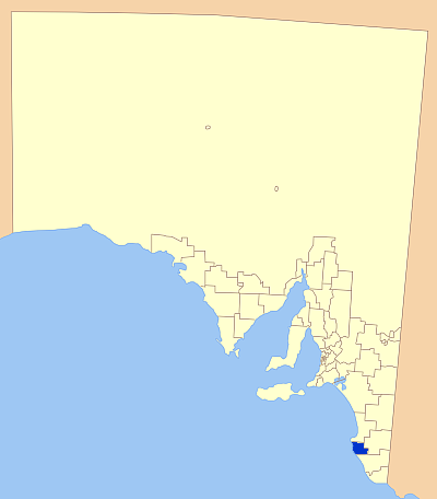
LGAs around District Council of Robe: Kingston District Council District Council of Robe Naracoorte Lucindale Council Wattle Range Council  Offices in Robe.
The District Council of Robe is a local government area located in the Limestone Coast area of South Australia. The main offices are in Robe, the town after which the council is named. The district relies on a mix of agriculture, fisheries and tourism as major components of its economy.
Contents
History
The district's coastline, like much of South Australia, was explored by Captains Matthew Flinders and Nicolas Baudin in 1802, with Baudin initially naming it after Admiral de Guichen. The first major town was officially founded and named 'Robe' by the South Australian Government 1846 after Major Frederick Holt Robe, Governor of South Australia who had selected the site in 1846.[2]
It was the first major town to be established in the south east of the colony. Greytown on Rivoli Bay had been surveyed a few months earlier and was the site of a small settlement but, Robe was the first administrative center and was the focus of public and commercial life in the area.[3]
The 'District Council of Robe' was proclaimed on 28 October 1869 to service the growing community at that time.[4]
By the 1880s, the district began a slow decline, and increasingly relied on its fishing and agricultural industries as its status as a major port and industrial hub decreased.[2]
Economy
The district still is heavily reliant on the fishing and agricultural industries, with Rock lobster one of the main catches in the area.
The district has a variety of agricultural industries, with cereal crops, beef cattle and sheep prominent. The district also has a thriving wine industry, lying near the Coonawarra wine region.[5]
Tourism has been an increasingly important part of the economy, with up to 15000 tourists every year.[5] The town has a large number of historic buildings, as well as natural attractions. The town is listed as one of the State's historical towns in the Heritage Conservation Branch's Master Interpretation Plan.
Localities
Robe is the only major town of the district, with a number of smaller towns also encompassed in the district. The full list is:
Boatswains Point, Bray, Comung, Greenways, Konetta, Lake Eliza, Mount Benson, Noolook Forest, Nora Creina, Robe and Woodleigh.[6]
Elected Members
Mayor: William Peden
CEO: Rob Kay
Councillors:
- Rino Dell'Antonio
- David Loxton
- Jenny Mathews
- Rolf Petrovic
- Peter Riseley
- Ned Wright
References
- ^ Australian Bureau of Statistics (30 March 2010). "Regional Population Growth, Australia, 2008–09". http://www.abs.gov.au/ausstats/abs@.nsf/Latestproducts/3218.0Main%20Features72008-09?opendocument&tabname=Summary&prodno=3218.0&issue=2008-09&num=&view=. Retrieved 3 June 2010.
- ^ a b Flinders Ranges Research, Robe, http://www.southaustralianhistory.com.au/robe.htm, retrieved 2007-06-10
- ^ District Council of Robe, History, archived from the original on 2007-08-30, http://web.archive.org/web/20070830002844/http://www.council.robe.sa.gov.au/site/page.cfm?u=120, retrieved 2007-06-10
- ^ SA Planning, Robe DC Development Plan, http://www.planning.sa.gov.au/go/development-plans/development-plans-online/country-plans, retrieved 2007-06-10
- ^ a b District Council of Robe, Statistics, archived from the original on 2007-08-30, http://web.archive.org/web/20070830002715/http://www.council.robe.sa.gov.au/site/page.cfm?u=121, retrieved 2007-06-10
- ^ LGA of SA, District Council of Robe, http://www.lga.sa.gov.au/site/page.cfm?c=4174, retrieved 2007-06-10
External links
Local Government Areas of South Australia Metropolitan Adelaide Adelaide · Adelaide Hills · Burnside · Campbelltown · Charles Sturt · Gawler · Holdfast Bay · Marion · Mitcham · Norwood Payneham & St Peters · Onkaparinga · Playford · Port Adelaide Enfield · Prospect · Salisbury · Tea Tree Gully · Unley · Walkerville · West TorrensEyre Peninsula Ceduna · Cleve · Elliston · Franklin Harbour · Kimba · Lower Eyre Peninsula · Port Augusta · Port Lincoln · Streaky Bay · Tumby Bay · Wudinna · WhyallaCentral Barossa · Barunga West · Clare and Gilbert Valleys · Copper Coast · Flinders Ranges · Goyder · Light · Mallala · Mount Remarkable · Northern Areas · Orroroo Carieton · Peterborough · Port Pirie · Wakefield · Yorke PeninsulaSouthern and Hills Murray Mallee Southeast Outback Categories:- Populated places established in 1869
- 1869 establishments in Australia
- Local Government Areas of South Australia
- Limestone Coast

Wikimedia Foundation. 2010.