- District Council of Ceduna
-
District Council of Ceduna
South Australia
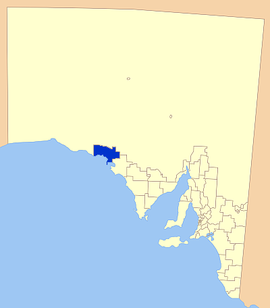
Location of the District Council of CedunaPopulation: 3,797(2009)[1] Established: 1896 Area: 5427.1 km² (2,095.4 sq mi) Mayor: Alan Suter Council Seat: Ceduna Region: Western Eyre Peninsula State District: Flinders Federal Division: Grey 
LGAs around District Council of Ceduna: Outback Areas Community Development Trust District Council of Ceduna Great Australian Bight District Council of Streaky Bay The District Council of Ceduna is a Local Government Area located on the far west coast of the Eyre Peninsula in South Australia. The district has a diverse business and industry with an estimated 240,000 tourists passing through every year.[2] The township of Ceduna is the focal point of the district.
Contents
Industry and history
The land in the district has long been used for agricultural purposes, in fact, between the 1850s and 1880s, much of the land was one large sheep station. Now most blocks are around 9,000 acres (36 km2) and mostly farming cereal crops such as wheat, oats and barley; as well as livestock, particularly sheep.[3]
Port Thevenard has been an exporter of gypsum and salt, with up to 1.2 million tonnes of gypsum being exported per year.
Smoky Bay and Denial Bay have been growing oysters using aquaculture for over ten years now, with Denial and Smoky Bay now the second and third largest producing areas in the state respectively.
Tourism is also a large part of the districts economy, with Smoky Bay and Ceduna attracting the largest crowds. The area's attractions are largely to do with the marine environment, with fishing and whale watching popular.
Localities
The town of Ceduna is the major town of the district with a number of smaller towns in the area including:
Other remote, less populated areas include:
Bonython, Carawa, Charra, Chinta, Goode, Kalanbi, Koonibba, Laura Bay, Maltee, Merghiny, Mudamuckla, Murat Bay, Nunjikompita, Petina, Pimbaacla, Puntabi, Uworra, Wallanippie and Wandana.[4]
Facilities
Ceduna contains all essential facilities including shopping centres, fuel stations, a hospital, an area school and a variety of accommodation. The smaller towns contain much less, with most having only a roadhouse and possibly a caravan park.
Recreational facilities include
Elected members
Mayor: Allan Suter
CEO: Tony Irvine
Councillors:
- Michael Ross
- Ian Bergmann
- Lynton Brown
- Peter Codrington
- Ken Maynard
- Danny Ronan
- Phill Stevens
Council meets on the third Wednesday of every month at 4 pm.
References
- ^ Australian Bureau of Statistics (30 March 2010). "Regional Population Growth, Australia, 2008–09". http://www.abs.gov.au/ausstats/abs@.nsf/Latestproducts/3218.0Main%20Features72008-09?opendocument&tabname=Summary&prodno=3218.0&issue=2008-09&num=&view=. Retrieved 4 June 2010.
- ^ "Council website". District Council of Ceduna. http://www.ceduna.net/. Retrieved 2007-03-02.
- ^ Ceduna Council. "Industry". Archived from the original on 2007-02-16. http://web.archive.org/web/20070216002321/http://www.ceduna.net/site/page.cfm?u=111. Retrieved 2007-05-19
- ^ LGA Association of SA. "DC of Ceduna". http://www.lga.sa.gov.au/site/page.cfm?c=4157. Retrieved 2007-05-19
External links
Towns and Localities of the District Council of Ceduna Bonython · Carawa · Ceduna · Charra · Chinta · Denial Bay · Goode · Kalanbi · Koonibba · Laura Bay · Maltee · Merghiny · Mundamuckla
Murat Bay · Nunjikompita · Petina · Pimbaacla · Puntabie · Smoky Bay · Thevenard · Uworra · Wallanippie · WandanaLocal Government Areas of South Australia Metropolitan Adelaide Adelaide · Adelaide Hills · Burnside · Campbelltown · Charles Sturt · Gawler · Holdfast Bay · Marion · Mitcham · Norwood Payneham & St Peters · Onkaparinga · Playford · Port Adelaide Enfield · Prospect · Salisbury · Tea Tree Gully · Unley · Walkerville · West TorrensEyre Peninsula Ceduna · Cleve · Elliston · Franklin Harbour · Kimba · Lower Eyre Peninsula · Port Augusta · Port Lincoln · Streaky Bay · Tumby Bay · Wudinna · WhyallaCentral Barossa · Barunga West · Clare and Gilbert Valleys · Copper Coast · Flinders Ranges · Goyder · Light · Mallala · Mount Remarkable · Northern Areas · Orroroo Carieton · Peterborough · Port Pirie · Wakefield · Yorke PeninsulaSouthern and Hills Murray Mallee Southeast Outback Coordinates: 32°08′00″S 133°41′00″E / 32.1333333333°S 133.683333333°E
Categories:- Populated places established in 1896
- 1896 establishments in Australia
- Eyre Peninsula
Wikimedia Foundation. 2010.
