- Northern Areas Council
-
Northern Areas Council
South Australia
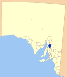
Location of the Northern Areas CouncilPopulation: 4,866(2009)[1] Established: 1997 Chairman: Allan Woolford Council Seat: Jamestown Region: Mid North Federal Division: Grey LGAs around Northern Areas Council: District Council of Mount Remarkable District Council of Orroroo Carrieton District Council of Peterborough Port Pirie Regional Council Northern Areas Council Regional Council of Goyder Wakefield Regional Council District Council of Clare and Gilbert Valleys Regional Council of Goyder Northern Areas Council is a local government area in the Mid North of South Australia. The main council offices are in Jamestown.
Most of the region was first settled in the early 1840s, only a few years after the settlement of Adelaide. Several explorers had passed through the area on their way to more remote places, including Edward John Eyre and John Horrocks.
The towns and localities covered by the council are Andrews, Belalie East, Belalie North, Bundaleer, Caltowie, Georgetown, Gladstone, Gulnare, Hornsdale, Huddleston, Jamestown, Laura, Mannanarie, Narridy, Spalding, Stone Hut, Tarcowie, Washpool, Yacka
The present Northern Areas Council is the result of numerous successive amalgamations of smaller town and district governments. Most recently, the District Councils of Rocky River, Spalding, and Jamestown merged on 3 May 1997. Rocky River Council was formed on 4 May 1988 from the district councils of Laura, Georgetown, and Gladstone. Jamestown District Council was a merger of the district council (itself the merger of Caltowie, Belalie and part of Yongala District Councils in 1935) with the Corporation of Jamestown in 1991.
References
- ^ Australian Bureau of Statistics (30 March 2010). "Regional Population Growth, Australia, 2008–09". http://www.abs.gov.au/ausstats/abs@.nsf/Latestproducts/3218.0Main%20Features72008-09?opendocument&tabname=Summary&prodno=3218.0&issue=2008-09&num=&view=. Retrieved 4 June 2010.
External links
Local Government Areas of South Australia Metropolitan Adelaide Adelaide · Adelaide Hills · Burnside · Campbelltown · Charles Sturt · Gawler · Holdfast Bay · Marion · Mitcham · Norwood Payneham & St Peters · Onkaparinga · Playford · Port Adelaide Enfield · Prospect · Salisbury · Tea Tree Gully · Unley · Walkerville · West TorrensEyre Peninsula Ceduna · Cleve · Elliston · Franklin Harbour · Kimba · Lower Eyre Peninsula · Port Augusta · Port Lincoln · Streaky Bay · Tumby Bay · Wudinna · WhyallaCentral Barossa · Barunga West · Clare and Gilbert Valleys · Copper Coast · Flinders Ranges · Goyder · Light · Mallala · Mount Remarkable · Northern Areas · Orroroo Carieton · Peterborough · Port Pirie · Wakefield · Yorke PeninsulaSouthern and Hills Murray Mallee Southeast Outback Coordinates: 33°12′14″S 138°36′20″E / 33.2038888889°S 138.605555556°E
Categories:- Populated places established in 1997
- 1997 establishments in Australia
- Local Government Areas of South Australia
- Mid North (South Australia)
Wikimedia Foundation. 2010.
