- District Council of Orroroo Carrieton
-
District Council of Orroroo Carrieton
South Australia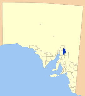
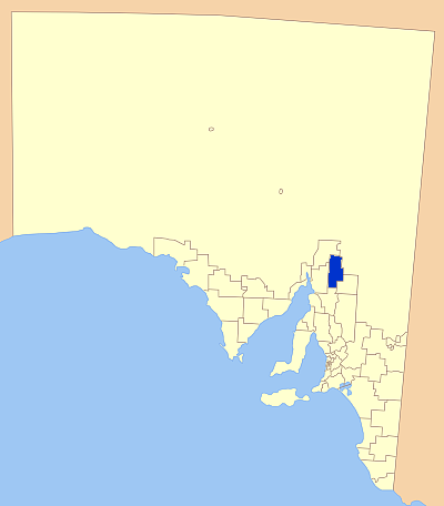
Location of District Council of Orroroo CarrietonPopulation: 938(2009)[1] State District: Electoral District of Stuart Federal Division: Division of Grey LGAs around District Council of Orroroo Carrieton: Flinders Ranges Council Flinders Ranges Council District Council of Mount Remarkable District Council of Orroroo Carrieton District Council of Northern Areas District Council of Peterborough The District Council of Orroroo Carrieton is a local government area in the Mid North of South Australia. The principal towns are Orroroo and Carrieton. Other locations in the council area are Belton, Bendelby, Black Rock, Erskine, Eurelia, Johnburgh, Morchard, Oladdie, Orroroo East, Pamatta, Pekina, Uroonda, Walloway, Wepowie, West Erskine, Yalpara, Yanyarrie and Yatina.
References
- ^ Australian Bureau of Statistics (30 March 2010). "Regional Population Growth, Australia, 2008–09". http://www.abs.gov.au/ausstats/abs@.nsf/Latestproducts/3218.0Main%20Features72008-09?opendocument&tabname=Summary&prodno=3218.0&issue=2008-09&num=&view=. Retrieved 4 June 2010.
External links
- Local Government Association - District Council of Orroroo Carrieton
- District Council of Orroroo Carrieton website
Local Government Areas of South Australia Metropolitan Adelaide Adelaide · Adelaide Hills · Burnside · Campbelltown · Charles Sturt · Gawler · Holdfast Bay · Marion · Mitcham · Norwood Payneham & St Peters · Onkaparinga · Playford · Port Adelaide Enfield · Prospect · Salisbury · Tea Tree Gully · Unley · Walkerville · West TorrensEyre Peninsula Ceduna · Cleve · Elliston · Franklin Harbour · Kimba · Lower Eyre Peninsula · Port Augusta · Port Lincoln · Streaky Bay · Tumby Bay · Wudinna · WhyallaCentral Barossa · Barunga West · Clare and Gilbert Valleys · Copper Coast · Flinders Ranges · Goyder · Light · Mallala · Mount Remarkable · Northern Areas · Orroroo Carieton · Peterborough · Port Pirie · Wakefield · Yorke PeninsulaSouthern and Hills Murray Mallee Southeast Outback Coordinates: 32°44′03″S 138°36′49″E / 32.7341666667°S 138.613611111°E
Categories:- South Australia geography stubs
- Local Government Areas of South Australia
- Mid North (South Australia)
Wikimedia Foundation. 2010.