- Kingston District Council
Infobox Australian Place
type = lga
name = Kingston District Council
state = sa
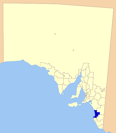
caption = Position of the CKingston District Council
pop = 2,226 (2001 census) [Census 2001 AUS|id=LGA43360|name=Lacepede (DC) (Local Government Area)|accessdate=2007-06-30]
area = 3337.7
est = 1873
seat = Kingston SE
mayor = Evan Flint
region =Limestone Coast
url = http://www.kingstondc.sa.gov.au
stategov = MacKillop
fedgov = Barker
near-nw =
near-n =The Coorong District Council
near-ne =Tatiara District Council
near-w =
near-e =
near-sw =
near-s =District Council of Robe
near-se =Naracoorte Lucindale Council The Kingston District Council is a Local Government Area located on the centralLimestone Coast ,South Australia . Established in1873 as the Lacepede District Council, the council name was changed in April2000 due to the new direction hoped to be taken by the council at that time.History
The area was originally settled by the
Ngarrindjeri Aborigines, who lived along theCoorong and extended across theMurray River to the present day site ofGoolwa .The first European to make contact with this stretch of coastline was the French explorer
Nicolas Baudin who discovered Lacepede Bay in1802 . [Citation
last = Sydney Morning Herald Travel | title = Kingston SE | url = http://www.smh.com.au/news/South-Australia/Kingston-SE/2005/02/17/1108500204342.html
access-date = 2007-05-26 ]The town of Kingston SE was established in
1856 , the town being named after the government surveyor, George Strickland Kingston by Governor McDonnell, in1858 .The district council was then established in1873 to serve the growing area, before having its name changed in2000 .Mayor Legoe justified the change at the ceremony, stating; "The decision to change the name of the Council was not a decision to change for the sake of change. It is a decision to change the image and identity of the Council to propel itselfinto the 21st Century". [Citation
last = Kingston District Council | title = Annual Report 2000/2001 | url = http://www.kingstondc.sa.gov.au/webdata/resources/files/Annual_Report_2000_2001.pdf
access-date = 2007-05-26 ]The district is mostly reliant on
agriculture , particularlycereal crops ,sheep andcattle . Cape Jaffa also hosts alobster fishing fleet, with othercommercial fishing also providing part of the area's economy.Tourism also plays a minor role, with Kingston SE a minor tourist destination, noted for its 'Big Lobster', with Mount Scott Conservation Park and Butcher's Gap Conservation Park also located in the district.Localities
Kingston SE is the central town to the district, being the largest town and also the seat of council. The full list of localities, including small towns and remoter areas includes:
Blackford, Bowaka, Cape Jaffa, Keilira, Kingston SE, Marcollat, Mount Benson, Port Caroline, Reedy Creek, Rosetown, Taratap, Tilley Swamp and Wangolina. [Citation
last = LGA odf South Australia | title = Kingston Regional Council | url = http://www.lga.sa.gov.au/site/page.cfm?c=4182
access-date = 2007-05-26 ]Elected Members
Mayor : Evan FlintCEO : Martin McCarthyCouncillors :
*Graham Gribble
*Gary Peters
*Shirey Twigg
*Alan Olley
*Christopher England
*David John Moreland
*Kenneth Garvie
*Reginald Lyon
*Graham Usher
*Christopher FranklingReferences
External links
* [http://www.kingstondc.sa.gov.au Council page]
* [http://www.lga.sa.gov.au/site/page.cfm?c=4182 LGA of South Australia - Kingston DC]
Wikimedia Foundation. 2010.