Inman Valley, South Australia
- Inman Valley, South Australia
Infobox Australian Place | type = town
name = Inman Valley
state = South Australia
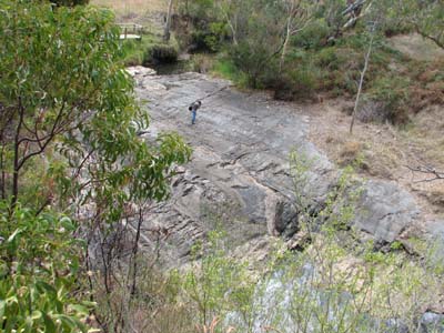
caption = Glaciated pavement in the Inman River
lga = City of Victor Harbor
postcode = 5211
est =
pop =
elevation=
maxtemp =
mintemp =
rainfall =
stategov =
fedgov =
dist1 = 86
dir1 = South
location1= Adelaide
Inman Valley (coord|-35|27|S|138|31|E|region:AU-SA_type:x), is a town south of Adelaide.
elwyn's Rock
Near the town is Selwyn's Rock, a glaciated pavement in the bed of the Inman River. It was first described by, and named for, Alfred Richard Cecil Selwyn, who was Victorian Government Geologist at the time. Glacial striations on the polished surface indicate glacial movement to the north-west. Boulder clays, tillites, and erratics are also common in the area, which underwent glaciation during the Permian (approximately 270 Ma).
The pavement was exposed during the Tertiary when the Inman River eroded the topography to its present-day surface.
External links
* [http://www.postcards.sa.com.au/features/inman_valley_keith.html Postcards (Channel 9 TV feautre)]
Wikimedia Foundation.
2010.
Look at other dictionaries:
Yankalilla, South Australia — Infobox Australian Place | type = town name = Yankalilla state = sa caption = Location of Yankalilla in South Australia lga = District Council of Yankalilla postcode = 5203 est = 1842 pop = 555 [ [http://www.censusdata.abs.gov.au/ABSNavigation/pre… … Wikipedia
Mount Crawford (South Australia) — Mount Crawford (centre right) from Tower Hill, looking east Mount Crawford is a hill in South Australia approximately 15 km north of Birdwood, in the Mount Lofty Ranges. It also refers to the Mount Crawford Forest which is a grouping of several… … Wikipedia
Hallett Cove, South Australia — Infobox Australian Place | type = suburb name = Hallett Cove city = Adelaide state = sa lga = City of Marion postcode = 5158 pop = 12,272 (2006 Census) [Census 2006 AUS|id=SSC41706|name=Hallett Cove (State Suburb)|quick=on|accessdate=2007 06 30]… … Wikipedia
McCracken, South Australia — McCracken Victor Harbor, South Australia Population: 1,549 (2006 Census)[1] Postcode … Wikipedia
List of postcodes in South Australia/numeric sort — Postcodes are used by Australia Post to identify postal districts in Australia. This list is sorted numerically to facilitate seeing which towns/suburbs share a postcode.5000s inner suburbs* 5000 Adelaide * 5001 GPO Boxes * 5005 University of… … Wikipedia
List of cities and towns in South Australia — This is a list of town and locality names in South Australia outside of the metropolitan postal area of Adelaide.:For a list of suburbs in metropolitan areas of Adelaide, see lists inside following individual city council articles: City of… … Wikipedia
Selwyn — is originally an Anglo Saxon name, also occasionally spelt Selwin, deriving from Sel (castle/house) wyn/win (friend), roughly meaning friend in the house or friend in the castle .The name Selwyn later became an English surname as well after the… … Wikipedia
City of Victor Harbor — South Australia Population: 13,608(2009)[1] Area: 386.5 km² (149.2 sq mi) … Wikipedia
Eudunda — South Australia Eudunda seen from the town lookout … Wikipedia
List of United Kingdom disasters by death toll — is a list of major disasters (excluding acts of war) which occurred in the United Kingdom (including territory that later became the Republic of Ireland) or involved UK citizens, in a definable incident or accident, e.g. a shipwreck, where the… … Wikipedia