- Eudunda
-
Eudunda
South Australia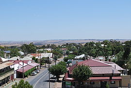
Eudunda seen from the town lookout
 Eudunda
Population: 640[1] Postcode: 5374 Coordinates: 34°10′S 139°05′E / 34.167°S 139.083°ECoordinates: 34°10′S 139°05′E / 34.167°S 139.083°E Location: LGA: Regional Council of Goyder State District: Stuart Federal Division: Grey Eudunda is a rural town in South Australia, roughly 103 kilometres northeast of Adelaide, established in 1870 after settlers began moving into the area in the 1860s. As of the 2006 census, Eudunda had a population of 640.[1]
Eudunda is in the Regional Council of Goyder local government area, the South Australian House of Assembly electoral district of Stuart and the Australian House of Representatives Division of Grey.
Contents
History
The earliest European activity in the district was overlanding, centred around Narcoota and the Narcoota Track in the late 1830s. Pastoralism soon followed, with expansive 'runs' being taken up for sheep grazing by men such as Lachlan McBean, Frederick Hansborough Dutton, and William Russell. Several decades then passed before closer settlement began. The founder of Eudunda was John Henry Hannan, who owned the land that was surveyed and divided for sale.
The town today
The town landscape has changed a little from the Edwardian era - with the "Gunn Street Extension" pushing the main road from the Top Pub on Gunn Street straight through what used to be railway land toward Bruce Street and the centre of the town. The new road has further enhanced the town gardens, seen on the drive into the main centre.
Eudunda was the birthplace of world-renowned author Colin Thiele, whose bronzed statue (by Chris Radford) is in the Centenary Gardens. The gardens also contain stone walls and tiled art featuring a Century of Transport.
Narcoota
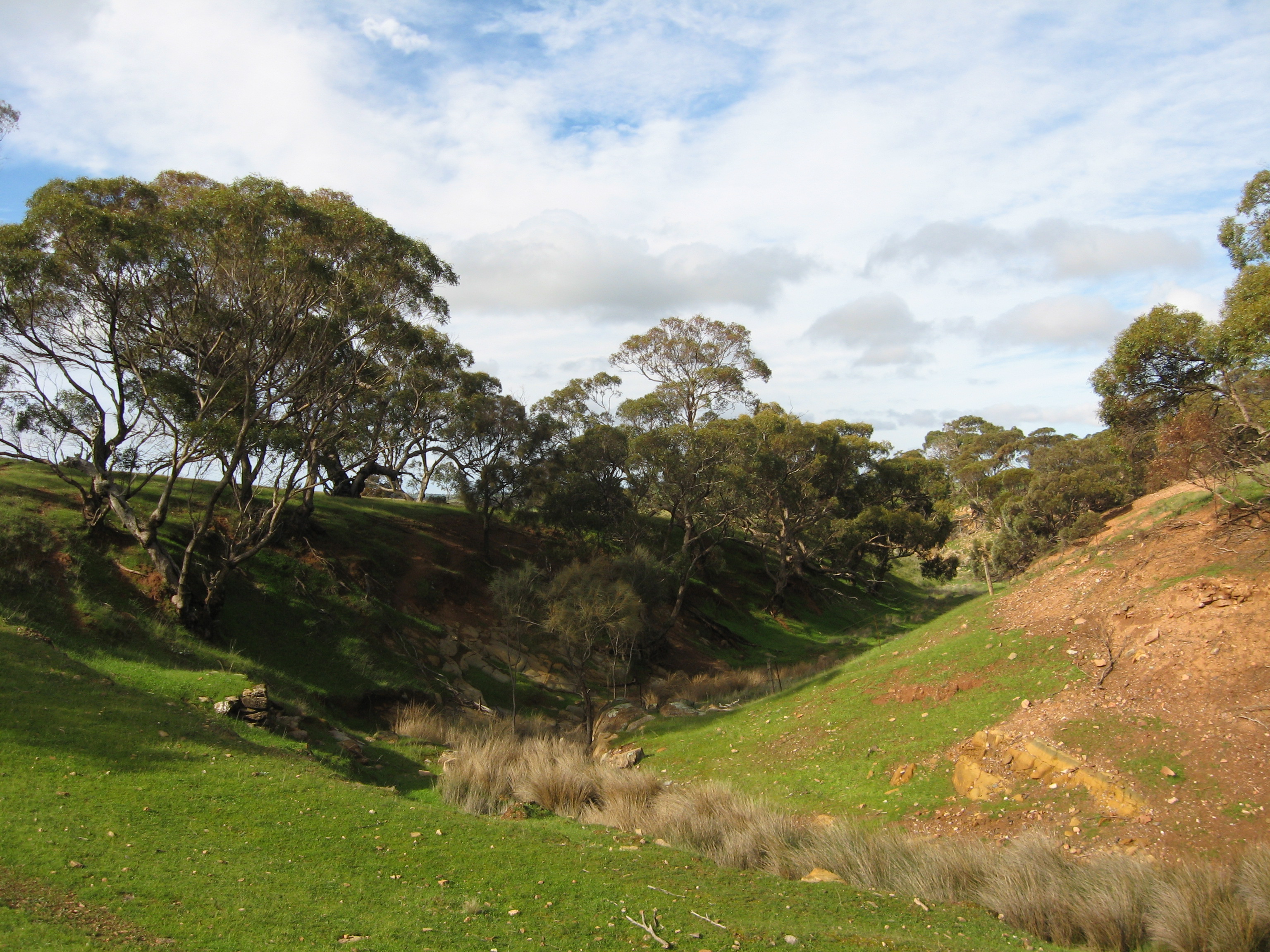
 Narcoota Creek, looking east
Narcoota and associated Narcoota Springs, lie in a valley near Neales Flat in the south of the Eudunda locality. The area featured prominently in the pioneering history of South Australia.
Located at Section 350, Hundred of Dutton, South Australia, 34°15′43″S 139°07′58″E / 34.26194°S 139.13278°E, Narcoota Springs are at the eastern escarpment of the Mount Lofty Ranges, 12 kilometers south of Eudunda, in a valley on Narcoota Creek, adjacent to the later named Smith Road.[2]
Narcoota, an indigenous name for the area, is of obscure meaning. It may be a corruption of ‘Narcoona’ – seeing – in reference to being a lookout over the Murray Plains.[3] European settlers adopted it from the outset, although it was variously spelt at first (examples are Nancoota, Tharcoota, and Nicota).
Narcoota Springs was a bustling stopover and watering place for the earliest explorers and pioneering overlanders, being a rare source of permanent water at the brink of the waterless Murray Plains. It was at the western end of the Narcoota Track, which from 1838 to 1842 was part of the main (and first) road between the Murray River and Adelaide. At the eastern end was The Pound, 9 km north of Blanchetown, which years later became named McBean Pound at Roonka Station. The overland road diverged at the Pound – one track went south toward Mount Barker and the other west to Narcoota, then on to Gawler Town and Adelaide.
Apart from overlanding parties droving large mobs of livestock from New South Wales, Narcoota Springs had some distinguished visitors in its heyday. They included Governor George Gawler and explorer Charles Sturt, as well as Henry Inman, Commander of Police, who passed through there at least five times.[4]
The first was in 1839 when Inman led a police party to the Weston Flat district to investigate conflict resulting in the death of one over-lander and an unknown number of Aboriginals. Months later he was back again when he took part in the exploration expedition of Governor Gawler from North West Bend to Mount Bryan.
In 1841 Inman was there again after his own over-landing party was attacked near Chowilla, losing 5,000 sheep. He again camped there as part of the 68-man police party led by Commissioner of Police Thomas Shuldham O'Halloran, sent by Governor George Grey to protect other over-landers at the Rufus River.
After a settlement was established in late 1841 by Edward John Eyre at Moorundie (8 km below Blanchetown, South Australia), the overland route then shifted further south, roughly following the present Sturt Highway between Blanchetown and Truro. The Narcoota Track became disused thereafter.[5]
Later in the 1840s a pastoral property named Narcoota Station was established. Nearby is Mount Rufus, where gold was discovered in 1868, but without much result. With closer settlement in the latter part of the 1800s, many grain farmers moved into the district, such that by 1900 there were busy schools and churches. Over a century later many stone ruins attest to the failure of close settlement, but those pioneering foundations produced the farms and grazing properties which thrive there today.
Geologically, the beds outcropping along Narcoota Creek are so typical in structure and stratigraphy of geological features occurring in several locations throughout the North Mount Lofty Ranges, that the name Narcoota Series has been adopted for the entire group.[6]
References
- ^ a b Australian Bureau of Statistics (25 October 2007). "Eudunda (L) (Urban Center/Locality)". 2006 Census QuickStats. http://www.censusdata.abs.gov.au/ABSNavigation/prenav/LocationSearch?collection=Census&period=2006&areacode=UCL407000&producttype=QuickStats&breadcrumb=PL&action=401. Retrieved 2010-01-18.
- ^ Geographical Names in Australia, Gazetteer of Australia 2008, Geoscience Australia
- ^ Australian Aboriginal Words, H.M. Cooper, SA Museum 1948 (1st ed.)
- ^ Inman: first commander of the SA Police / Max Slee (Seaview Press, 2010)
- ^ Hills, valley and plains: history of the Eudunda District / compiled by Betty Dreckow (Eudunda, 1986).
- ^ The Geology of part of the North Mount Lofty Ranges, by Paul S. Hossfeld, M.Sc., FGS, GRGS. (SA Museum 1928)
External links
- eudunda.net - Eudunda & Region of Southern Goyder's Web Portal
- Eudunda Community, Business and Tourism Committee
Towns and localities of the Regional Council of Goyder Aberdeen · Apoinga · Australia Plain · Baldina · Baldry · Booborowie · Bower · Brady Creek · Braemar (Station) · Bright · Brownlow · Buchanan · Bundey · Burra · Burra Eastern Districts · Burra North · Canowie · Canowie Belt · Collinsville · Copperhouse · Deep Creek · Dutton · Emu Downs (Hill) · Eudunda · Farrell Flat · Franklyn · Frankton · Geranium Plains · Gum Creek · Hallelujah Hills · Hallett · Hampden · Hansborough · Hanson · Julia · Ketchowla · Koonoona · Kooringa · Leighton · Mallet (Reservoir) · Mongolata · Mount Bryan · Neales · Neath Vale · Ngapala · North Booborwie · Pandappa · Peep Hill · Point Bass · Porter Lagoon · Robertstown · Rocky Plain · Steinfeld · Sutherlands · Terowie · Thistle Beds · Tracy · Ulooloo · Whyte-Yarcowie · Willalo · Worlds End · Worlds End Creek · Yarcowie · Yongala ValeCategories:- Towns in South Australia
- Geography of South Australia
- Geology of South Australia


Wikimedia Foundation. 2010.