- Kapunda, South Australia
Infobox Australian Place | type = town
name = Kapunda
state = South Australia
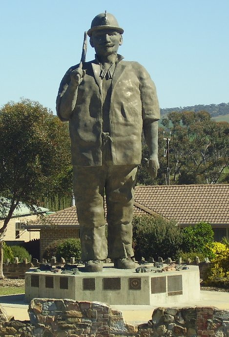
caption = "Map the Miner" after reconstruction
lga =Light Regional Council
postcode = 5373
est = 1843
pop = 3,000
elevation= 245
maxtemp = 21.6
mintemp = 9.8
rainfall = 493.8
stategov =Electoral district of Stuart
fedgov =Division of Wakefield
dist1 = 77
dir1 = North
location1= AdelaideKapunda coord|34|20|S|138|54|E|region:AU-SA_type:city(3,000)|display=title is a town near the
Barossa Valley inSouth Australia . It was established after a discovery in 1842 of significantcopper deposits.The southern entrance to the town has been dominated since
1988 by the 8-metre-tall statue of Map Kernow ("the son ofCornwall "), a traditional Cornish miner. The statue was destroyed by a fire on the morning of1 June 2006 [cite news |url=http://www.abc.net.au/northandwest/stories/s1653185.htm |title=Map the Miner destroyed in fire |date=2006-06-01 |accessdate=2006-06-06 |publisher=Australian Broadcasting Corporation ] but has since been rebuilt by its creator, Ben van Zetten.History
Francis Dutton and Captain Charles Bagot, who both ran
sheep in the area, discoveredcopper ore outcrops in 1842. They purchased convert|80|acre|ha|0 around the outcrop, beginning mining early in 1844 after goodassay results. Mining began with the removal of surface ore and had progressed to underground mining by the end of the year. [Drew, G.J. and Jones, J. (1988), p. 6]Kapunda is famous as the home of Sir
Sidney Kidman . He was a major cattle pastoralist who at one time owned 68 properties with a total area larger than theBritish Isles . He held annual horse sales at Kapunda with up to 3,000 horses sold during the week. His house, "Eringa", was donated to the Education Department, and is still used as the administration building for Kapunda High School. The town also has the unfortunate honour of being titled the most haunted town in Australia after a television documentary focused on the town. Most locals were not amused, however it has led to an increase in the amount of tourists that visit the area. Due to this, the ruins of the Reformatory, located outside the town, were bulldozed, although some locals still believe in the ghost stories popular in town. The town is also close to the historical Anlaby Station and the manor, houses, gardens and other buildings on the property, many of which are being restored by its current owners.Copper was discovered at Kapunda in1842 and was mined from there until1879 . There are also quarries near the town which provide finemarble ranging from dark blue to white. Marble from the Kapunda quarries was used to face Parliament House inAdelaide .Today, Kapunda is a producer of
cereal crops , mainly wheat, barley and oats. Value-added services carried out by local industry include stock feed milling and hay processing. Kapunda is a contributor to the wine-growing industry centred in the nearbyBarossa Valley .Kapunda has played host to the [http://www.kapundaceltic.org/ Kapunda Celtic Music Festival] since
1976 . Each year the town celebrates its Celtic heritage with concerts, dancing and pub sessions.Government
Kapunda is in the state
electoral district of Stuart , the federalDivision of Wakefield , and the centre of theLight Regional Council .Weather
climate chart|Kapunda
14.6|29.7|20.6
14.6|29.3|20.6
12.7|26.6|23.6
10.1|21.5|37.9
7.9|17.5|54.1
6.2|14.2|58.2
5.3|13.5|59.7
5.8|15.0|61.1
6.9|17.9|55.1
8.8|21.3|47.1
11.2|25.1|30.9
13.2|27.9|25.1
float=none
source=Bureau of Meteorology,Sept 19 2007 [cite web|url=http://www.bom.gov.au/climate/averages/tables/cw_023307.shtml |title=Climate Climate statistics for Australian locations, Summary for Kapunda |publisher=Australian Bureau of Meteorology| accessdate=2007-09-25]Notes
References
*cite book |title=Discovering historic Kapunda, South Australia | last = Drew |first=G.J. | coauthors= Jones, J. | publisher=Department of Mines and Energy, Kapunda tourism committee |location = Adelaide | year=1988 |isbn = 0-7243-4277-X
Wikimedia Foundation. 2010.