- Port Neill, South Australia
Infobox Australian Place | type = town
name = Port Neill
state = sa
|thumb|250px
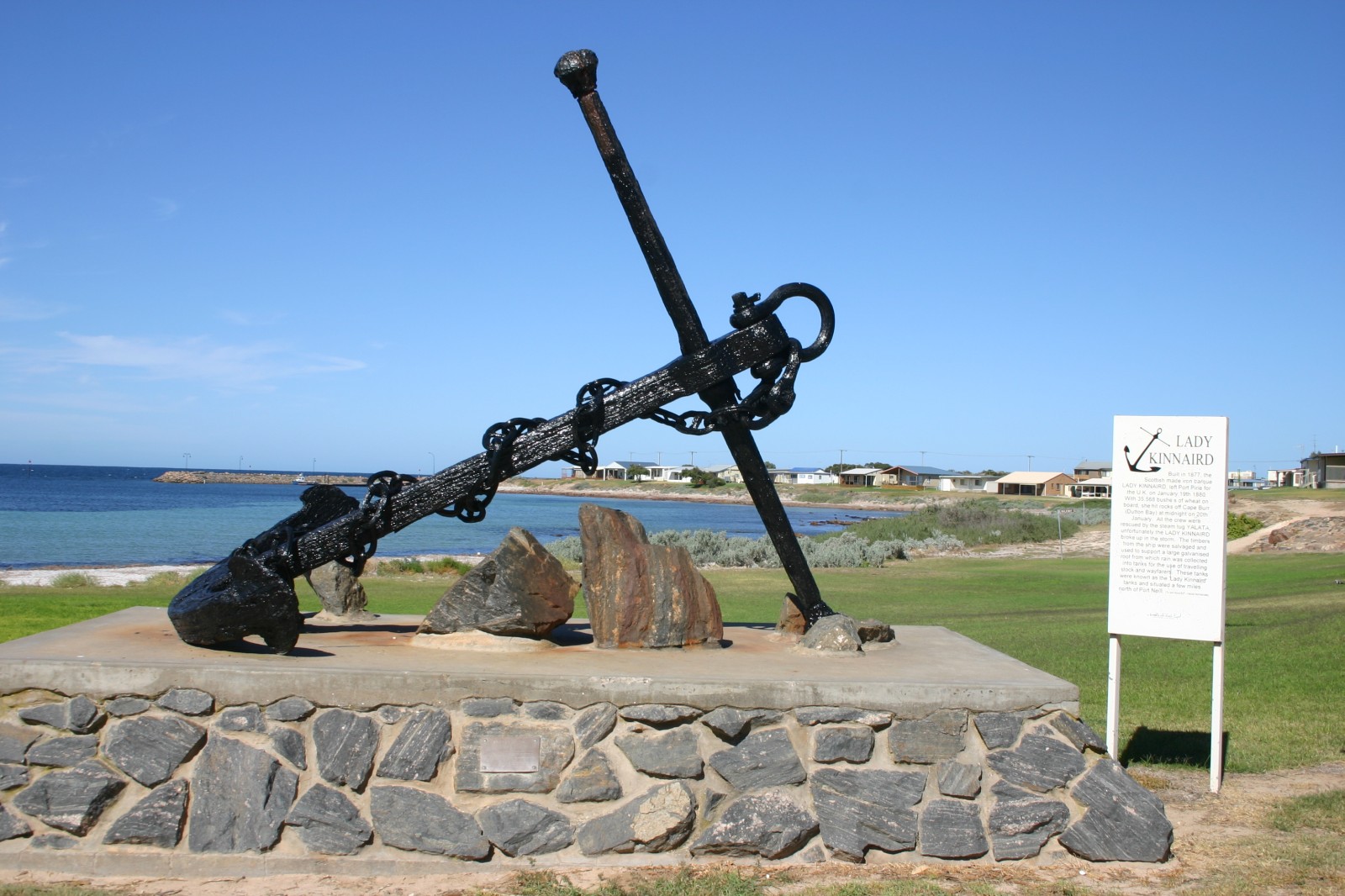
caption = "Lady Kinnaird" anchor on the Foreshore at Port Neill
lga =District Council of Tumby Bay
postcode = 5604
est = 1903
pop = 374
elevation= 0
maxtemp =
mintemp =
rainfall =
stategov = Flinders
fedgov = Grey
dist1 = 576
dir1 = West
location1= AdelaidePort Neill is a small coastal town on the eastern side of the
Eyre Peninsula , inSouth Australia about 3km off the Lincoln Highway between the major towns of Whyalla and Port Lincoln. It is 576 km by road from Adelaide.The town offers protected beaches for swimming, as well as providing a venue for fishing, boating, sailing, skiing or skin-diving.
History
Matthew Flinders passed by and reported on7 March 1802 of 'low front land, somewhat sandy, with raised land inland and of a barren appearance, its elevation diminishing to the northward.'The explorer,
Edward John Eyre passed through the area in 1840. The first settlers arrived in 1873 when John Tennant and his son Andrew took up land around the bay, then known as Mottled Cove.The town was first called "Carrow" and was gazetted in 1903 and laid out in 1909. However, some confusion was caused by the similarity of the name to the town of "Warrow" and the town was renamed Port Neill on
19 September 1940 . The name of the town honours a Warden of the Marine Board, Andrew Sinclair Neill.The first jetty was built in 1912 to ship wheat and wool from the district. Shipments continued until 1970 when shipments by road to Port Lincoln's larger harbour facilities and grain silos commenced.
The "Lady Kinnaird" Anchor and a World War II cannon are situated on the foreshore lawns which provide an ideal family picnic spot. The "Lady Kinnard" was an iron barque carrying a load of wheat from Port Pirie to the
United Kingdom which struck rocks off Cape Burr onJanuary 20 ,1880 and foundered and broke up. All aboard were rescued. The timbers from the vessel were salvaged and used to support a large galvanised roof to collect rain water into tanks for the use of wayfarers and travelling stock. These tanks became known as the "Lady Kinnaird" tanks and were situated a few miles north of Port Neill.The Port Neill jetty and a goods shed indicate the town's past as a once busy seaport.
Economy
As in the past, much of Port Neill's
economy is derived from the surroundingagricultural districts, withcereal crops andsheep prominently farmed.Like many
coastal towns of theEyre Peninsula , Port Neill is a well establishedtourist destination, with town numbers swelling duringsummer holidays . As well as its history, Port Neill offers a laid back country atmosphere and a number of recreational activities.Fishing is popular from the townjetty , the surrounding beaches and fromboats , with boat launching facilities available. A number of other watersports includingswimming andsnorkelling are on offer in the clean sandybay .The town has a number of accommodation options including a
caravan park ,hotels and apartments.Community
At the time of the
2001 census , Port Neill'spopulation was 374, with the vast majorityAustralian born. Of those thatimmigrated , most came from theUnited Kingdom .Christianity is the dominantreligion in the area with most following theCatholic ,Anglican and Uniting denominations. There are a number ofchurches throughout the town.Port Neill has a number of
sporting clubs and facilities, including anoval ,tennis courts andbasketball courts.The town has a large range of facilities including
accommodation anddining facilities and a wide variety of shops.Gallery
External links
* [http://www.tep.com.au/region/port_neill.htm Tourism Eyre Peninsula]
* [http://www.smh.com.au/news/South-Australia/Port-Neill/2005/02/17/1108500204610.html Sydney Morning Herald Travel]
Wikimedia Foundation. 2010.