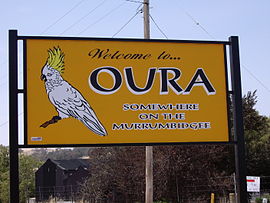
- Oura, New South Wales
-
Oura
New South Wales
Entering OuraPopulation: 380 (2006 Census)[1] Established: 226 Postcode: 2650 Coordinates: 35°5′56″S 147°35′53″E / 35.09889°S 147.59806°ECoordinates: 35°5′56″S 147°35′53″E / 35.09889°S 147.59806°E Location: - 15 km (9 mi) from Wagga Wagga
- 20 km (12 mi) from Wantabadgery
LGA: City of Wagga Wagga County: Clarendon Parish: Oura State District: Wagga Wagga Federal Division: Riverina Oura is a town community in the central east part of the Riverina and situated about 15 kilometres north east from Wagga Wagga and 20 kilometres south west from Wantabadgery. At the 2006 census, Oura had a population of 380 people.[1]
Notes and references
- ^ a b Australian Bureau of Statistics (25 October 2007). "Oura (State Suburb)". 2006 Census QuickStats. http://www.censusdata.abs.gov.au/ABSNavigation/prenav/LocationSearch?collection=Census&period=2006&areacode=SSC18481&producttype=QuickStats&breadcrumb=PL&action=401. Retrieved 10 November 2009.
Suburbs and Towns in the City of Wagga Wagga Local Government Area Suburbs: Ashmont · Bomen · Bourkelands · Boorooma · Cartwrights Hill · Charles Sturt University · Downside · East Wagga Wagga · Estella · Eunanoreenya · Forest Hill · Glenfield Park · Gobbagombalin · Gregadoo · Gumly Gumly · Kapooka · Kooringal · Lake Albert · Lloyd · Moorong · Mount Austin · North Wagga Wagga · San Isidore · Springvale · The Gap · Tatton · Tolland · Turvey Park · Wagga Wagga
Outlying Towns: Alfredtown · Burrandana · Collingullie · Currawarna · Galore · Humula · Ladysmith · Mangoplah · Oura · Tarcutta · UranquintyMain Article: Local Government Areas of New South WalesCategories:- Towns in New South Wales
- Towns in the Riverina
Wikimedia Foundation. 2010.


