- Mathoura
-
Mathoura
New South Wales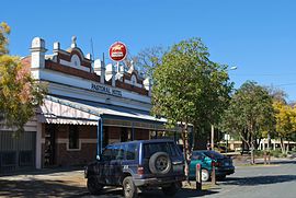
Pastoral Hotel, with the Soldiers Memorial Garden and the Tattersalls Club Hotel in the background
 Mathoura
Population: 653(2006 Census)[1] Established: 1860 Postcode: 2710 Coordinates: 35°49′S 144°54′E / 35.817°S 144.9°ECoordinates: 35°49′S 144°54′E / 35.817°S 144.9°E Elevation: 105 m (344 ft) Location: - 790 km (491 mi) from Sydney
- 258 km (160 mi) from Melbourne
- 42 km (26 mi) from Echuca (Vic)
- 32 km (20 mi) from Deniliquin
- 42 km (26 mi) from Barmah (Vic)
LGA: Murray Shire County: Cadell State District: Murray-Darling Federal Division: Farrer Mean max temp Mean min temp Annual rainfall 22.0 °C
72 °F9.1 °C
48 °F437.3 mm
17.2 inMathoura (pronounced /məˈθaʊrə/) is a small town in the Riverina region of southern New South Wales, Australia, in the Murray Shire local government area. At the 2006 census, Mathoura had a population of 653.[1] The town's name is derived from an aboriginal word for 'windy'.[2]
Contents
History
In 1848 a reserve was established on Gulpa Creek by Surveyor Townsend. The locality became known as Redbank. By 1853 W. Moore Carter had established an inn at Redbank and in 1856 he was permitted to purchase 12 acres (4.9 ha) at £2 10s. per acre. By 1860 Carter had about 40 acres (16.2 ha) under cultivation, including a 5 acres (2.0 ha) vineyard.
A petition in 1859 called on the Government to put up the reserve at Redbank for sale. However there were others who considered a more suitable position for a village was at Hill Plain, where Mr. Stuckey had erected an inn (opened in June 1860 and managed by John Atkinson).
In 1860 Surveyor McCulloch laid out the township of Redbank near the site of Carter's Redbank Inn. In 1864 Carter was growing tobacco at Redbank (from which cigars were manufactured).
A traveller passing through Redbank in mid-1865 stated that “Mr. Carter has established a brick public-house… situated on the bank of the Gulpa Creek”. The writer added: “I observed three or four acres fenced and stocked with fruit trees, withered and dried up”.[3]
In 1865 Henry Burton, a circus proprietor, purchased the Redbank Inn; he held the license until at least 1870.
Mathoura Post Office opened on 1 September 1867.[4]
The village was made a stopping-place on the Victorian railway line that was extended into New South Wales to Deniliquin. By 1879 it was reported that the village had about six houses of "straggling order" and was supported principally by the timber trade. By 1882 a flour mill had been established at Mathoura; there were two hotels, the Mathoura Inn and the Railway Hotel, as well as a school, a Union church and a sawmill.[5]
Today
The town has an Australian Rules football team competing in the Picola & District Football League.
Golfers play at the course of the Mathoura Golf Club on the Cobb Highway.[6]
See also
References
- ^ a b Australian Bureau of Statistics (25 October 2007). "Mathoura (L) (Urban Centre/Locality)". 2006 Census QuickStats. http://www.censusdata.abs.gov.au/ABSNavigation/prenav/LocationSearch?collection=Census&period=2006&areacode=UCL151000&producttype=QuickStats&breadcrumb=PL&action=401. Retrieved 27 October 2009.
- ^ "Mathoura". Geographical Names Board of New South Wales. http://www.gnb.nsw.gov.au/name_search/extract?id=anlpXtqbGH. Retrieved 27 October 2009.
- ^ ’A Tour in the Riverine District’ (letter to the editor), Sydney Morning Herald, 13 July 1865, p. 2.
- ^ Premier Postal History, Post Office List, https://www.premierpostal.com/cgi-bin/wsProd.sh/Viewpocdwrapper.p?SortBy=VIC&country=, retrieved 2008-04-11
- ^ Jervis, James, 'The Western Riverina: A History of Its Development', Royal Australian Historical Society Journal and Proceedings, Vol. XXXVIII 1952, p. 190.
- ^ Golf Select, Mathoura, http://www.golfselect.com.au/armchair/courseView.aspx?course_id=1024, retrieved 2009-05-11
External links
- Mathoura Rail Siding [1]
Categories:- Towns in New South Wales
- Towns in the Riverina


Wikimedia Foundation. 2010.