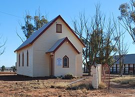
- Corobimilla, New South Wales
-
Corobimilla
New South Wales
Union ChurchPostcode: 2700 Coordinates: 34°51′0″S 146°25′0″E / 34.85°S 146.416667°ECoordinates: 34°51′0″S 146°25′0″E / 34.85°S 146.416667°E Location: - 12 km (7 mi) from Morundah
- 20 km (12 mi) from Narrandera
LGA: Narrandera Shire County: Mitchell State District: Murrumbidgee Corobimilla is a village locality in the central east part of the Riverina.[1] It is situated by road, about 12 kilometres northeast from Morundah and 20 kilometres south west from Narrandera.
The place name Corobimilla is derived from the local Aboriginal word meaning "tree struck by lightning".[2]
Cuddell Siding Post Office opened on 1 August 1895, was renamed Corobimilla in 1904, and closed in 1988.[3]
Notes
- ^ Geographical Names Board of NSW
- ^ NSW Geographical Names Board
- ^ Premier Postal History, Post Office List, https://www.premierpostal.com/cgi-bin/wsProd.sh/Viewpocdwrapper.p?SortBy=NSW&country=, retrieved 2009-06-11
External links
Barellan · Binya · Colinroobie · Corobimilla · Grong Grong · Kamarah · Kywong · Moombooldool · Narrandera
Main Article: Local Government Areas of New South WalesCategories:- Towns in New South Wales
- Towns in the Riverina
- Australian Aboriginal placenames
- Riverina geography stubs
Wikimedia Foundation. 2010.


