- Oaklands, New South Wales
-
Oaklands
New South Wales
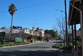
Milthorpe Street, the main street of OaklandsPopulation: 239[1] Postcode: 2646 Elevation: 128 m (420 ft) Location: - 615 km (382 mi) SW of Sydney
- 335 km (208 mi) NW of Melbourne
- 144 km (89 mi) SW of Wagga Wagga
- 61 km (38 mi) NW of Corowa
LGA: Urana Shire County: Urana State District: Murray-Darling Federal Division: Farrer Oaklands is a town in the Riverina district of southern New South Wales, Australia. The town is located 615 kilometres south west of the state capital, Sydney and 105 kilometres north west of Albury. Oaklands is in the Urana Shire Local government area and at the 2006 census, had a population of 239.[1].
Oaklands Post Office opened on 16 June 1890. [2]
The major industry in the Oaklands region is agriculture, including the production of wheat and rice and is a major grain handling area. It is the home of the Oaklands Diuris, a threatened native orchid that is currently only found in the Oaklands region.[3]
Contents
Transport
Rail
A standard gauge branch line from the New South Wales Government Railways Main Southern railway line at The Rock was extended from Lockhart to Oaklands in 1912.[4] A broad gauge branch line from the Victorian Railways Melbourne-Albury railway line at Benalla was extended from Yarrawonga to Oaklands in 1938, creating a break-of-gauge until the New South Wales Government Railways line was closed south of Boree Creek.
There are several stations between Yarrawonga and Oaklands. [5]
Gauge conversion
With the conversion of the North East railway to Albury, New South Wales to standard gauge, starting 2008, the Oaklands branch railway becomes a gauge orphan. After much lobbying in parliament and by the community, the 113km branch has been converted to 1,435 mm (4 ft 8 1⁄2 in).
Mileposts
Oaklands is at least 313.127km from Melbourne and 674.580km from Sydney.
Preceding station NSW Branch lines Following station Terminus Oaklands Line (closed section)Coorabintowards The RockReferences
- ^ a b Australian Bureau of Statistics (25 October 2007). "Oaklands (L) (Urban Centre/Locality)". 2006 Census QuickStats. http://www.censusdata.abs.gov.au/ABSNavigation/prenav/LocationSearch?collection=Census&period=2006&areacode=UCL162000&producttype=QuickStats&breadcrumb=PL&action=401. Retrieved 2008-09-01.
- ^ Premier Postal History. "Post Office List". https://www.premierpostal.com/cgi-bin/wsProd.sh/Viewpocdwrapper.p?SortBy=NSW&country=. Retrieved 2009-06-11.
- ^ NSW Department of Environment and Conservation - Oaklands Diuris Retrieved 1 November 2006
- ^ "Oaklands Branch". www.nswrail.net. http://www.nswrail.net/lines/show.php?name=NSW:oaklands. Retrieved 2006-12-11.
- ^ Yarrawong to Oaklands
External links
- Urana Shire Council - Official Site
Coordinates: 35°32′S 146°10′E / 35.533°S 146.167°E
Towns in the Urana Shire Local Government Area Boree Creek · Morundah · Oaklands · Rand · Urana
Categories:- Towns in New South Wales
- Towns in the Riverina
Wikimedia Foundation. 2010.


