- Downside, New South Wales
-
Downside
New South Wales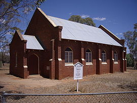
St Stephens - Downside
 Downside
Postcode: 2650 Coordinates: 34°58′35″S 147°20′39″E / 34.97639°S 147.34417°ECoordinates: 34°58′35″S 147°20′39″E / 34.97639°S 147.34417°E Elevation: 279 m (915 ft) Location: - 15 km (9 mi) from Wagga Wagga
- 24 km (15 mi) from Coolamon
LGA: City of Wagga Wagga County: Clarendon State District: Wagga Wagga Downside is a farming community in the central east part of the Riverina and situated about 15 kilometres north west from Wagga Wagga and 24 kilometres south east from Coolamon.[1]
Downside Post Office opened on 15 August 1878 and closed in 1905. [2]
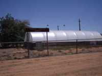 Downside Landcare Nursery
Notes and references
- ^ "Geographical Names Register Extract". Geographical Names Board of New South Wales. New South Wales Government. http://www.gnb.nsw.gov.au/name_search/extract?id=SXwGWyxOJP. Retrieved 12 December 2010.
- ^ Premier Postal History. "Post Office List". https://www.premierpostal.com/cgi-bin/wsProd.sh/Viewpocdwrapper.p?SortBy=NSW&country=. Retrieved 2009-06-11
Suburbs and Towns in the City of Wagga Wagga Local Government Area Suburbs: Ashmont · Bomen · Bourkelands · Boorooma · Cartwrights Hill · Charles Sturt University · Downside · East Wagga Wagga · Estella · Eunanoreenya · Forest Hill · Glenfield Park · Gobbagombalin · Gregadoo · Gumly Gumly · Kapooka · Kooringal · Lake Albert · Lloyd · Moorong · Mount Austin · North Wagga Wagga · San Isidore · Springvale · The Gap · Tatton · Tolland · Turvey Park · Wagga Wagga
Outlying Towns: Alfredtown · Burrandana · Collingullie · Currawarna · Galore · Humula · Ladysmith · Mangoplah · Oura · Tarcutta · UranquintyCategories:- Suburbs of Wagga Wagga


Wikimedia Foundation. 2010.