- City of Wagga Wagga
-
Wagga Wagga
New South Wales
Population: 62,904(2009)[1] Established: 1981 Area: 4823.92 km² (1,862.5 sq mi) [2] Mayor: Kerry Pascoe Council Seat: Wagga Wagga (Cnr Baylis and Morrow Street)[3] Region: Riverina State District: Wagga Wagga Federal Division: Riverina 
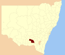
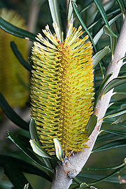
LGAs around Wagga Wagga: Coolamon Junee Gundagai Narrandera Wagga Wagga Tumut Lockhart Greater Hume Tumbarumba City of Wagga Wagga is a Local Government Area in New South Wales, Australia, in southern New South Wales. The floral emblem for the city is the Silver Banksia.[4]
The Wagga Wagga City Council was formed from the amalgamation of City of Wagga Wagga with Mitchell and Kyeamba Shires in 1981[5]. 22 December 2009, Wagga Wagga City Council announced that Phil Pinyon would be appointed as the General Manager (GM) of the Wagga Wagga City Council after Lyn Russell, who joined the council in March 2008, left the position of GM after being appointed as Chief Executive Officer at Cairns Regional Council in November 2009.[6][7][8]
It includes the suburbs of Ashmont, Bomen, Bourkelands, Boorooma, Cartwrights Hill, East Wagga Wagga, Estella, Forest Hill, Glenfield Park, Gumly Gumly, Kapooka, Kooringal, Lake Albert, Lloyd, Mount Austin, North Wagga Wagga, San Isidore, Tatton, Tolland, Turvey Park, and Wagga Wagga as well as the towns of Tarcutta, Ladysmith, Mangoplah, Uranquinty and Collingullie.
Politics
 Cr. Wayne Geale, being interviewed by Sky News Australia reporter, Gemma Veness.
Wagga Wagga City Council Party 2008-2012 Independent 9 Australian Business Party 1 The Greens 1 Total 11 The current (2008–2012) Wagga Wagga City Council comprises 11 councillors, including the Mayor and Deputy Mayor[9]
Councillor Party Notes Donna Argus Independent Alan Brown Independent Yvonne Braid Independent Wayne Geale Independent Ray Goodlass Greens Deputy Mayor[10] Garry Hiscock Australian Business Party[11] Joined Australian Business Party in 2009 Rod Kendall Independent Kerry Pascoe Independent Mayor[10] Clint Uden Independent Lindsay Vidler Independent Kevin Wales Independent See also
- Riverina Water County Council
References
- ^ Australian Bureau of Statistics (30 March 2010). "Regional Population Growth, Australia, 2008–09". http://www.abs.gov.au/ausstats/abs@.nsf/Latestproducts/3218.0Main%20Features42008-09?opendocument&tabname=Summary&prodno=3218.0&issue=2008-09&num=&view=. Retrieved 3 June 2010.
- ^ "Wagga Wagga Regional Profile". Riverina Regional Development Board. http://www.rrdb.com.au/rivprofile/waggawagga.htm. Retrieved 2008-08-28.
- ^ "Wagga Wagga City Council". Department of Local Government. http://www.dlg.nsw.gov.au/dlg/dlghome/dlg_CouncilContactDetails.asp?slacode=7750. Retrieved 2006-11-30.
- ^ Wise and Salt Tolerant Plants.pdf "Water Wise and Salt Tolerant Plants". Wagga Wagga City Council. http://www.wagga.nsw.gov.au/resources/documents/Water Wise and Salt Tolerant Plants.pdf. Retrieved 2008-04-08.
- ^ "History of Wagga Wagga". Wagga Wagga City Council. http://www.wagga.nsw.gov.au/www/default.asp?guiValue=1150AAD1-48CC-442A-A8DA-F647D12ADE2A. Retrieved 2008-04-08.
- ^ "New Wagga council GM looks to the future". ABC Riverina NSW. Australian Broadcasting Corporation. 2008-04-04. http://www.abc.net.au/news/stories/2008/04/04/2207903.htm?site=riverina. Retrieved 2008-04-08.
- ^ "New CEO gets straight to it". The Daily Advertiser. Fairfax. 2008-04-01. http://dailyadvertiser.yourguide.com.au/news/local/general/new-ceo-gets-straight-to-it/1213782.html. Retrieved 2008-04-08.
- ^ "Council appoints new CEO". The Cairns Post. News Limited. 2009-10-01. http://www.cairns.com.au/article/2009/10/01/67231_local-news.html. Retrieved 2009-10-01.
- ^ Grimson, Ken (2008-09-24). "7 fresh faces join council". The Daily Advertiser. http://dailyadvertiser.yourguide.com.au/news/local/news/general/7-fresh-faces-join-council/1280055.aspx. Retrieved 2008-09-24.
- ^ a b "Shock result in mayoral election". The Daily Advertiser. 26 September 2011. http://www.dailyadvertiser.com.au/news/local/news/general/shock-result-in-mayoral-election/2304443.aspx. Retrieved 26 September 2011.
- ^ Higgins, Ben (2009-07-21). "Hiscock joins new party". The Daily Advertiser. http://www.dailyadvertiser.com.au/news/local/news/general/hiscock-joins-new-party/1573466.aspx. Retrieved 2009-07-21.
Coordinates: 35°08′S 147°22′E / 35.133°S 147.367°E
Suburbs and Towns in the City of Wagga Wagga Local Government Area Suburbs: Ashmont · Bomen · Bourkelands · Boorooma · Cartwrights Hill · Charles Sturt University · Downside · East Wagga Wagga · Estella · Eunanoreenya · Forest Hill · Glenfield Park · Gobbagombalin · Gregadoo · Gumly Gumly · Kapooka · Kooringal · Lake Albert · Lloyd · Moorong · Mount Austin · North Wagga Wagga · San Isidore · Springvale · The Gap · Tatton · Tolland · Turvey Park · Wagga Wagga
Outlying Towns: Alfredtown · Burrandana · Collingullie · Currawarna · Galore · Humula · Ladysmith · Mangoplah · Oura · Tarcutta · UranquintyMain Article: Local Government Areas of New South WalesLocal Government Areas of New South Wales Metropolitan Sydney Inner SydneyAshfield · Botany Bay · Burwood · Canada Bay · Canterbury · Hurstville · Kogarah · Lane Cove · Leichhardt · Manly · Marrickville · Mosman · North Sydney · Randwick · Rockdale · Strathfield · Sydney · Waverley · Willoughby · WoollahraOuter SydneyAuburn · Bankstown · Blacktown · Camden · Campbelltown · Fairfield · The Hills · Holroyd · Hornsby · Hunter's Hill · Ku-ring-gai · Liverpool · Parramatta · Penrith · Pittwater · Ryde · Sutherland · WarringahSydney SurroundsMid North Coast Bellingen · Clarence Valley · Coffs Harbour · Greater Taree · Kempsey · Nambucca · Port Macquarie-Hastings · Lord Howe IslandMurray Murrumbidgee Carrathool · Coolamon · Cootamundra · Griffith · Gundagai · Hay · Junee · Leeton · Lockhart · Murrumbidgee · Narrandera · Temora · Wagga WaggaHunter Cessnock · Dungog · Gloucester · Great Lakes · Lake Macquarie · Maitland · Muswellbrook · Newcastle · Port Stephens · Singleton · Upper HunterIllawarra Richmond Tweed Southeastern Bega · Bombala · Boorowa · Cooma-Monaro · Eurobodalla · Goulburn Mulwaree · Harden · Palerang · Queanbeyan · Snowy River · Tumut · Upper Lachlan · Yass Valley · YoungNorthern Armadale Dumaresq · Glen Innes-Severn · Gunnedah · Guyra · Gwydir · Inverell · Liverpool Plains · Moree Plains · Narrabri · Tamworth · Tenterfield · Uralla · WalchaCentral West North Western Far West Local Government Areas of the Riverina Cities: Albury · Griffith · Wagga Wagga
Towns: Deniliquin
Shires: Balranald · Berrigan · Carrathool · Conargo · Coolamon · Cootamundra · Corowa · Greater Hume · Gundagai · Hay · Jerilderie · Junee · Leeton · Lockhart · Murray · Murrumbidgee · Narrandera · Temora · Tumbarumba · Tumut · Urana · Wakool
Categories:- Populated places established in 1981
- 1981 establishments in Australia
- Local Government Areas of New South Wales
- Wagga Wagga
- Riverina geography stubs
Wikimedia Foundation. 2010.


