- Oberon Shire
-
Oberon Shire
New South Wales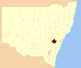
Location in New South WalesPopulation: 5,391(2009)[1] Area: 3659 km² (1,412.7 sq mi) Mayor: Keith Sullivan Council Seat: Oberon (137-139 Oberon Street) [2] Region: Central West State District: Bathurst Federal Division: Calare LGAs around Oberon Shire: Bathurst Bathurst Lithgow Bathurst Oberon Shire Blue Mountains Upper Lachlan Goulburn Wollondilly Oberon Shire is a local government area in the Central West region of New South Wales, Australia. Oberon Shire includes Oberon, Black Springs, Shooters Hill, Edith and O'Connell.
Demographics
According to the Australian Bureau Statistics [3], there:
- were 5,503 people as at 30 June 2006, the 125th largest Local Government Area in New South Wales. It was equal to less than 0.1% of the New South Wales population of 6,827,694
- was an increase of 60 people over the year to 30 June 2006, the 99th largest population growth in a Local Government Area in New South Wales. It was equal to 0.1% of the 58,753 increase in the population of New South Wales
- was, in percentage terms, an increase of 1.1% in the number of people over the year to 30 June 2006, the 41st fastest growth in population of a Local Government Area in New South Wales. In New South Wales the population grew by 0.9%
- was an increase in population over the 10 years to 30 June 2006 of 648 people or 13% (1.3% in annual average terms), the 32nd highest rate of a Local Government Area in New South Wales. In New South Wales the population grew by 622,966 or 10% (1.0% in annual average terms) over the same period.
References
- ^ Australian Bureau of Statistics (30 March 2010). "Regional Population Growth, Australia, 2008–09". http://www.abs.gov.au/ausstats/abs@.nsf/Latestproducts/3218.0Main%20Features42008-09?opendocument&tabname=Summary&prodno=3218.0&issue=2008-09&num=&view=. Retrieved 3 June 2010.
- ^ "Oberon Council". Department of Local Government. http://www.dlg.nsw.gov.au/dlg/dlghome/dlg_Regions.asp?regiontype=2&slacode=6110®ion=CW. Retrieved 2006-11-09.
- ^ "Regional Population Growth, Australia, 2005-06 (catalogue no.: 3218.0)". Australian Bureau of Statistics. http://abs.gov.au. Retrieved 2007-03-12.
Coordinates: 33°43′S 149°52′E / 33.717°S 149.867°E
Local Government Areas of New South Wales Metropolitan Sydney Inner SydneyAshfield · Botany Bay · Burwood · Canada Bay · Canterbury · Hurstville · Kogarah · Lane Cove · Leichhardt · Manly · Marrickville · Mosman · North Sydney · Randwick · Rockdale · Strathfield · Sydney · Waverley · Willoughby · WoollahraOuter SydneyAuburn · Bankstown · Blacktown · Camden · Campbelltown · Fairfield · The Hills · Holroyd · Hornsby · Hunter's Hill · Ku-ring-gai · Liverpool · Parramatta · Penrith · Pittwater · Ryde · Sutherland · WarringahSydney SurroundsMid North Coast Bellingen · Clarence Valley · Coffs Harbour · Greater Taree · Kempsey · Nambucca · Port Macquarie-Hastings · Lord Howe IslandMurray Murrumbidgee Carrathool · Coolamon · Cootamundra · Griffith · Gundagai · Hay · Junee · Leeton · Lockhart · Murrumbidgee · Narrandera · Temora · Wagga WaggaHunter Cessnock · Dungog · Gloucester · Great Lakes · Lake Macquarie · Maitland · Muswellbrook · Newcastle · Port Stephens · Singleton · Upper HunterIllawarra Richmond Tweed Southeastern Bega · Bombala · Boorowa · Cooma-Monaro · Eurobodalla · Goulburn Mulwaree · Harden · Palerang · Queanbeyan · Snowy River · Tumut · Upper Lachlan · Yass Valley · YoungNorthern Armadale Dumaresq · Glen Innes-Severn · Gunnedah · Guyra · Gwydir · Inverell · Liverpool Plains · Moree Plains · Narrabri · Tamworth · Tenterfield · Uralla · WalchaCentral West Bathurst · Bland · Blayney · Cabonne · Cowra · Forbes · Lachlan · Lithgow · Mid-Western · Oberon · Orange · Parkes · WeddinNorth Western Far West Categories:- Local Government Areas of New South Wales
- New South Wales geography stubs

Wikimedia Foundation. 2010.