- Corowa Shire
-
Corowa Shire
New South Wales
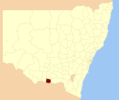
Location in New South WalesPopulation: 11,685(2009)[1] Area: 2324 km² (897.3 sq mi) Mayor: Gary Poidevin Council Seat: Corowa (Corner Bow Street and Honour Avenue)[2] Region: Riverina State District: Albury Federal Division: Division of Farrer LGAs around Corowa Shire: Jerilderie Urana Lockhart Berrigan Corowa Shire Greater Hume Moira (Vic) Indigo (Vic) Indigo (Vic) Corowa Shire is a local government area in New South Wales, Australia in the Riverina region. It is on the Murray River and the Riverina Highway.
Its includes the towns of Corowa, Howlong, Balldale, Coreen and Daysdale, Rennie and Mulwala.
Council
Corowa Shire Council is composed of nine councillors elected proportionally. The mayor is not directly elected.[3] The current makeup of the council is as follows:[3]
Party Councillors Independents and Unaffiliated 9 Total 9 The current council, elected in 2008, is:[3]
Councillor Party Notes Gary Poidevin Unaffiliated Mayor Jan Doyle Unaffiliated Bill Bott Unaffiliated Fred Longmire Unaffiliated Norm Wales Independent Fiona Schirmer Unaffiliated Deputy Mayor Mark Shields Unaffiliated Gail Law Independent Daryl Davey Independent References
- ^ Australian Bureau of Statistics (30 March 2010). "Regional Population Growth, Australia, 2008–09". http://www.abs.gov.au/ausstats/abs@.nsf/Latestproducts/3218.0Main%20Features42008-09?opendocument&tabname=Summary&prodno=3218.0&issue=2008-09&num=&view=. Retrieved 3 June 2010.
- ^ "Corowa Shire Council". Department of Local Government. http://www.dlg.nsw.gov.au/dlg/dlghome/dlg_CouncilContactDetails.asp?slacode=2310. Retrieved 2006-11-08.
- ^ a b c "Corowa Shire Council". 2008 Election results. Electoral Commission NSW. http://www.lg.elections.nsw.gov.au/LGE2008/result.Corowa.html. Retrieved 2009-06-16.[dead link]
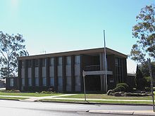 Corowa Shire Council offices
Coordinates: 35°59′S 146°23′E / 35.983°S 146.383°E
Towns in the Corowa Shire Local Government Area Main Article: Local Government Areas of New South WalesLocal Government Areas of the Riverina Cities: Albury · Griffith · Wagga Wagga
Towns: Deniliquin
Shires: Balranald · Berrigan · Carrathool · Conargo · Coolamon · Cootamundra · Corowa · Greater Hume · Gundagai · Hay · Jerilderie · Junee · Leeton · Lockhart · Murray · Murrumbidgee · Narrandera · Temora · Tumbarumba · Tumut · Urana · Wakool
Local Government Areas of New South Wales Metropolitan Sydney Inner SydneyAshfield · Botany Bay · Burwood · Canada Bay · Canterbury · Hurstville · Kogarah · Lane Cove · Leichhardt · Manly · Marrickville · Mosman · North Sydney · Randwick · Rockdale · Strathfield · Sydney · Waverley · Willoughby · WoollahraOuter SydneyAuburn · Bankstown · Blacktown · Camden · Campbelltown · Fairfield · The Hills · Holroyd · Hornsby · Hunter's Hill · Ku-ring-gai · Liverpool · Parramatta · Penrith · Pittwater · Ryde · Sutherland · WarringahSydney SurroundsMid North Coast Bellingen · Clarence Valley · Coffs Harbour · Greater Taree · Kempsey · Nambucca · Port Macquarie-Hastings · Lord Howe IslandMurray Albury · Balranald · Berrigan · Conargo · Corowa · Deniliquin · Greater Hume · Jerilderie · Murray · Tumbarumba · Urana · Wakool · WentworthMurrumbidgee Carrathool · Coolamon · Cootamundra · Griffith · Gundagai · Hay · Junee · Leeton · Lockhart · Murrumbidgee · Narrandera · Temora · Wagga WaggaHunter Cessnock · Dungog · Gloucester · Great Lakes · Lake Macquarie · Maitland · Muswellbrook · Newcastle · Port Stephens · Singleton · Upper HunterIllawarra Richmond Tweed Southeastern Bega · Bombala · Boorowa · Cooma-Monaro · Eurobodalla · Goulburn Mulwaree · Harden · Palerang · Queanbeyan · Snowy River · Tumut · Upper Lachlan · Yass Valley · YoungNorthern Armadale Dumaresq · Glen Innes-Severn · Gunnedah · Guyra · Gwydir · Inverell · Liverpool Plains · Moree Plains · Narrabri · Tamworth · Tenterfield · Uralla · WalchaCentral West North Western Far West Categories:- Local Government Areas of New South Wales
- Local Government Areas of the Riverina, New South Wales
- Riverina geography stubs

Wikimedia Foundation. 2010.