- Nambucca Shire
-
Nambucca Shire
New South Wales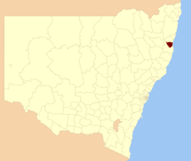
Location in New South WalesPopulation: 19,186(2009)[1] Area: 1491 km² (575.7 sq mi) Mayor: Rhonda Hoban[2] Council Seat: Macksville (44 Princess Street) Region: Mid North Coast State District: Oxley Federal Division: Cowper LGAs around Nambucca Shire: Guyra Bellingen Pacific Ocean Armidale Dumaresq Nambucca Shire Pacific Ocean Kempsey Kempsey Pacific Ocean Nambucca Shire is a Local Government Area on the Mid North Coast of New South Wales, Australia. It is on the Pacific Highway and the North Coast railway line.
In 2006, the Shire had a population density of 12.004/km2 (31.090/sq mi). There were 954 (5.4%) indigenous persons and 14,943 (84.6%) Australian-born persons in the Shire.[3]
Contents
Towns and localities
- Allgomerra
- Bowraville
- Bulingary
- Burrapine
- Cedar Butt
- Eungai Creek
- Eungai Rail
- Gumma
- Hyland Park
- Ketelghay
- Macksville
- Medlow
- Missabotti
- Nambucca Heads
- Newee Creek
- Scotts Head
- Talarm
- Tamban
- Taylors Arm
- Tewinga
- Thumb Creek
- Utungun
- Valla
- Valla Beach
- Warrell Creek
- Wirrimbi
- Yarranbella
Demographics
In the 2006 Census of Population and Housing there were 17,898 usual residents living in Nambucca Shire. Of this count, 8,778 (or 49%) were males and 9,119 (or 51%) were females.
By age, 19% of the population was under 15 years old, 59% were between 15 and 65, and 23% were over 65 years old.
Most people living in Nambucca Shire were born in Australia (84%). The median age was 46 years.
Council
Nambucca Shire Council is composed of eight councillors elected proportionally. The mayor is directly elected.[4] The current makeup of the council is as follows:[4]
Party Councillors Independents and Unaffiliated 9 Total 9 The current council, elected in 2008, is:[4]
Councillor Party Notes Rhonda Hoban Unaffiliated Mayor John Ainsworth Unaffiliated Mike Moran Independent Paula Flack Independent Anne Smyth Independent Elaine South Unaffiliated Martin Ballangarry Independent Brian Finlayson Unaffiliated Janet Court Independent Economy
According to the 2006 Census of Population and Housing, the median invididual income was $296 per week (equal to approximately $15,434 per year). The median family income in 2006 was $642 per week (equal to approximately $33,476 per year); and, the median household income in 2006 was $562 per week (equal to approximately $29,304 per year).
There were 5,447 people employed in 2006 (to give an employment to working age population ratio of 0.52), and 974 people unemployed. The most common occupations were Managers (15%); Technicians and Trades Workers (15%); and, Professionals (15%). The top 5 industries for employment were School Education (7.2%); Supermarket and Grocery Stores (4.6%); Residential Care Services (3.8%); Cafes, Restaurants and Takeaway Food Services (3.3%); and, Sheep, Beef Cattle and Grain Farming (2.7%).
Housing
In the 2006 Census of Population and Housing, the median housing loan repayment was $900 per month. This equated to 40% of median household income.
The median rent in 2006 was $146 per week. This equated to just under 26% of median household income.
The average household size was 2.3 persons.
Local media
Radio Stations 2CS-FM (106.3), Star FM (105.5 & 105.1), 2MC-FM (106.7), Triple J (91.5 & 96.3), 2NVR FM (105.9)
The Nambucca Valley's community radio station, 2NVR 105.9FM, focuses on the Macksville, Bowraville, Nambucca Heads and surrounding communities.
Newspapers Midcoast Observer, Hibiscus Happynings, Guardian News,Coffs Coast Advocate
Television ABC, ABC2, SBS, SBS NEWS, PRIME COFFS HARBOUR (SEVEN), SOUTHERN CROSS TEN (TEN), NBN (WIN, NINE)
References
- ^ Australian Bureau of Statistics (30 March 2010). "Regional Population Growth, Australia, 2008–09". http://www.abs.gov.au/ausstats/abs@.nsf/Latestproducts/3218.0Main%20Features42008-09?opendocument&tabname=Summary&prodno=3218.0&issue=2008-09&num=&view=. Retrieved 3 June 2010.
- ^ "Nambucca Shire Council". Department of Local Government. http://www.dlg.nsw.gov.au/dlg/dlghome/dlg_CouncilContactDetails.asp?slacode=5700. Retrieved 2006-11-21.
- ^ "Regional Population Growth, Australia, 2004-05". Australian Bureau of Statistics. http://abs.gov.au/Ausstats/abs@.nsf/Latestproducts/3218.0Main%20Features22004-05?opendocument&tabname=Summary&prodno=3218.0&issue=2004-05&num=&view=. Retrieved 2006-12-03.
- ^ a b c "Nambucca Shire Council". 2008 Election results. Electoral Commission NSW. http://www.lg.elections.nsw.gov.au/LGE2008/result.Nambucca.html. Retrieved 2009-08-03.[dead link]
Local Government Areas of New South Wales Metropolitan Sydney Inner SydneyAshfield · Botany Bay · Burwood · Canada Bay · Canterbury · Hurstville · Kogarah · Lane Cove · Leichhardt · Manly · Marrickville · Mosman · North Sydney · Randwick · Rockdale · Strathfield · Sydney · Waverley · Willoughby · WoollahraOuter SydneyAuburn · Bankstown · Blacktown · Camden · Campbelltown · Fairfield · The Hills · Holroyd · Hornsby · Hunter's Hill · Ku-ring-gai · Liverpool · Parramatta · Penrith · Pittwater · Ryde · Sutherland · WarringahSydney SurroundsMid North Coast Bellingen · Clarence Valley · Coffs Harbour · Greater Taree · Kempsey · Nambucca · Port Macquarie-Hastings · Lord Howe IslandMurray Murrumbidgee Carrathool · Coolamon · Cootamundra · Griffith · Gundagai · Hay · Junee · Leeton · Lockhart · Murrumbidgee · Narrandera · Temora · Wagga WaggaHunter Cessnock · Dungog · Gloucester · Great Lakes · Lake Macquarie · Maitland · Muswellbrook · Newcastle · Port Stephens · Singleton · Upper HunterIllawarra Richmond Tweed Southeastern Bega · Bombala · Boorowa · Cooma-Monaro · Eurobodalla · Goulburn Mulwaree · Harden · Palerang · Queanbeyan · Snowy River · Tumut · Upper Lachlan · Yass Valley · YoungNorthern Armadale Dumaresq · Glen Innes-Severn · Gunnedah · Guyra · Gwydir · Inverell · Liverpool Plains · Moree Plains · Narrabri · Tamworth · Tenterfield · Uralla · WalchaCentral West North Western Far West

Wikimedia Foundation. 2010.