- City of Sydney
-
City of Sydney
New South Wales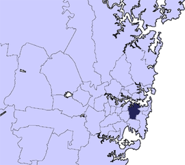
Population: 182,226 (permanent) (2010)[1] (19th)
26,000 (visitors)[2][3]• Density: 7289/km² (18,878.4/sq mi) Established: 1842 Area: 25 km² (9.7 sq mi) Mayor: Lord Mayor Clover Moore (Independent) Council Seat: Sydney CBD (Town Hall) Region: Metropolitan Sydney State District: Sydney, Balmain, Heffron, Marrickville Federal Division: Sydney, Wentworth, Kingsford Smith 
LGAs around City of Sydney: Municipality of Lane Cove City of Willoughby North Sydney Council / Municipality of Mosman Municipality of Leichhardt City of Sydney Municipality of Woollahra Marrickville Council City of Botany Bay City of Randwick  The City of Sydney coat of arms
The City of Sydney is the Local Government Area (LGA) covering the Sydney central business district and surrounding inner city suburbs of the greater metropolitan area of Sydney, Australia. The leader of the City of Sydney holds the title of the Lord Mayor of Sydney.
Suburbs within the boundaries of the City of Sydney before the merger include the actual downtown or central business district of Sydney itself, Pyrmont and Ultimo to the west, Haymarket to the south and Woolloomooloo to the east and other suburbs. On 6 February 2004, the former LGA of the City of South Sydney was formally merged into the City of Sydney.
Contents
Geography
The CBD is roughly bounded by Circular Quay and the Harbour to the north, Macquarie Street to the east, the Western Distributor to the west and Liverpool Street to the south. Suburbs within the City of South Sydney before the merger included Alexandria, Darlington (now mostly occupied by the University of Sydney), Erskineville, Newtown, Redfern, Glebe, Waterloo, Paddington.
Demographics
- As of 2010 there were 182,226 permanent residents and a daily average of 26,000 accommodation visitors bringing the total population of the City of Sydney to over 200,000 people.[2]
According to the Australian Bureau of Statistics:[4]
- an increase of 4,488 people over the year to 30 June 2010, the 3rd largest population growth in a Local Government Area in New South Wales. It was equal to 4.3% of the 105,421 increase in the population of New South Wales over the same period.
- was, in percentage terms, an increase of 2.5% in the number of people over the year to 30 June 2010, the 9th fastest growth in population of a Local Government Area in New South Wales. In New South Wales the population grew by 1.5%
Suburbs in the local government area
Suburbs within or partially within the City of Sydney are:
Localities in the local government area
Localities in the City of Sydney are:
- Broadway
- Central
- Chinatown
- Circular Quay
- Darling Harbour
- The Domain
- East Sydney
- Goat Island
- Garden Island
- Kings Cross
- Macdonaldtown
- Railway Square
- Strawberry Hills
- Wynyard
History
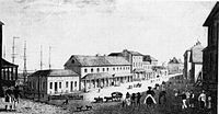
The name Sydney comes from "Sydney Cove" which is where the English admiral Arthur Phillip established the first settlement, after arriving with the First Fleet. On 26 January 1788, he named it after Thomas Townshend, 1st Viscount Sydney, who was the home secretary at the time, and the man responsible for the plan for the convict colony in Australia.
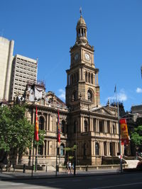
The "City of Sydney" was established on 20 July 1842[5] by the Corporation Act which encompasses present-day Woolloomooloo, Surry Hills, Chippendale and Pyrmont, an area of 11.65 km². There were six wards established by boundary posts. A boundary post still exists in front of Sydney Square.
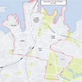
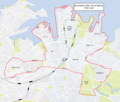
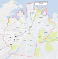
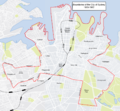
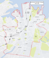
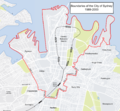
The boundaries of the City of Sydney have changed fairly regularly since 1900. The Municipality of Camperdown was merged with the city in 1909. Added in 1949 were Alexandria, Darlington, Erskineville, Newtown, Redfern, Glebe, Waterloo, and Paddington. In 1968 the boundaries were changed and many of these suburbs moved to be part of a new municipality of South Sydney. South Sydney was brought back into the city in 1982, but became separate again under the City of Sydney Act of 1988 and then became smaller than its original size at 6.19 km². It grew again in February 2004 with the merger of the two council areas, and now has a population of approximately 170,000 people.
The City of Sydney is a major supporter of the Sydney Peace Prize.
Boundary changes
Government and infrastructure
Transport New South Wales has its headquarters in Chippendale, City of Sydney.[6]
Economy
GEO Group Australia has its headquarters in the Sydney CBD.[7] Google has offices in the Pyrmont suburb.[8]
In 1975 Qantas was headquartered in the Qantas House in the City of Sydney.[9]
Contains the Central Business District, with a prominent Financial hub surrounding Martin Place.
Politics
As noted above, the electoral boundary of the City of Sydney have been significantly altered by state governments on at least four occasions since 1945, with advantageous effect to the governing party in the New South Wales Parliament at the time. Successive State governments of both major parties, the Labor Party and the Liberal Party, have re-drawn the electoral boundaries to include inner suburbs that are traditionally supportive of them, and to exclude suburbs that are traditionally hostile. In 1972 the Council had prepared the City of Sydney Strategic Plan, only the second city (after New York) to prepare a comprehensive assessment and plan of major issues for the future. With triennial reviews, this guided development of the City for twenty years,[10] and a similar planning process has continued.
A 1987 Liberal re-organisation saw Sydney Council split, with southern suburbs forming a new South Sydney council. This was thought to advantage the Liberal government of the day, as the southern suburbs had traditionally voted Labor.
In 2004, the Labor State Government undid this change, again merging the councils of the City of Sydney and the City of South Sydney. Critics claimed that this was performed with the intention of creating a "super-council" which would be under the control of the Australian Labor Party (ALP), which also controlled the State Government. Subsequent to this merger, an election took place on 27 March 2004 which resulted in the independent candidate Clover Moore defeating the high-profile ALP candidate, former federal minister Michael Lee and winning the position of Lord Mayor. Critics of the merger claimed that this was a result of a voter backlash against the party for attempting to create the "super-council".
Sydney City Council is composed of ten councillors, including the Lord Mayor, elected proportionally, for a fixed four year term of office.
The current General Manager is Ms. Monica Barone.
The Lord Mayor is directly elected.[11] The current makeup of the council, including the Lord Mayor, is as follows:[11]
Party Councillors Clover Moore Independent Team 6 The Greens 2 Australian Labor Party 1 Liberal Party of Australia 1 Total 10 The current council, elected in 2008, is:[11]
Councillor Party Notes Clover Moore Clover Moore Independents Lord Mayor John McInerney Clover Moore Independents Chris Harris Greens Meredith Burgmann Labor Shayne Mallard Liberal Marcelle Hoff Clover Moore Independents Deputy Lord Mayor [11] Phillip Black Clover Moore Independents Di Tornai Clover Moore Independents Robert Kok Clover Moore Independents Irene Doutney Greens Sister cities
Sydney City Council maintains sister city relations with the following cities:[12]
 San Francisco, California, USA, since 1968
 Nagoya, Japan, since 1980
 Wellington, New Zealand, since 1982
 Portsmouth, United Kingdom, since 1984
 Guangzhou, China, since 1985
 Florence, Italy, since 1986
 Rome, Italy
In addition, Sydney City Council has partnership agreements with these places:[citation needed]
See also
External links
- Official website for the City of Sydney
- City of Sydney travel guide from Wikitravel
- A Photographer's Guide to Sydney Skyline
References
- ^ http://www.abs.gov.au/AUSSTATS/abs@.nsf/DetailsPage/3218.02009-10
- ^ a b Sydney at a Glance
- ^ Average population working in the CBD 293,000
- ^ "Regional Population Growth, Australia, 2009-10 (catalogue no.: 3218.0)". Australian Bureau of Statistics. http://www.abs.gov.au/AUSSTATS/abs@.nsf/DetailsPage/3218.02009-10. Retrieved 4 November 2011.
- ^ "History of Sydney City Council" (pdf). City of Sydney. http://www.cityofsydney.nsw.gov.au/AboutSydney/documents/history/hs_chos_history_of_council_1001.pdf. Retrieved 9 February 2007.
- ^ "Copyright and Disclaimer." Transport New South Wales. Retrieved on 8 December 2010. "Transport NSW 18 Lee Street Chippendale NSW 2008"
- ^ "THE GEO GROUP AUSTRALIA PTY LTD." GEO Group. Retrieved on 22 November 2010. "Head Office Level 18, National Mutual Center, 44 Market Street Sydney,New South Wales 2000 Australia ."
- ^ "Google Offices." Google. Retrieved on 12 July 2009.
- ^ World Airline Directory. Flight International. 20 March 1975. "498.
- ^ See, for example, City of Sydney Strategic Plan, 1980
- ^ a b c d "Sydney City Council". 2008 Election results. Electoral Commission NSW. http://www.lg.elections.nsw.gov.au/LGE2008/result.Sydney.html. Retrieved 3 August 2009.[dead link]
- ^ [1]
Suburbs and localities within the City of Sydney Suburbs Alexandria · Annandale · Barangaroo · Beaconsfield · Camperdown · Centennial Park · Chippendale · Darlinghurst · Darlington · Dawes Point · Elizabeth Bay · Erskineville · Eveleigh · Forest Lodge · Glebe · Haymarket · Millers Point · Moore Park · Newtown · Paddington · Potts Point · Pyrmont · Redfern · Rosebery · Rushcutters Bay · Surry Hills · Sydney CBD · The Rocks · Ultimo · Waterloo · Woolloomooloo · Zetland
Localities List of Sydney suburbs Regions of Sydney Local Government Areas of Sydney Ashfield · Auburn · Bankstown · Blacktown · Botany Bay · Burwood · Camden · Campbelltown · Canada Bay · Canterbury · Fairfield · The Hills · Holroyd · Hornsby · Hunter's Hill · Hurstville · Kogarah · Ku-ring-gai · Lane Cove · Leichhardt · Liverpool · Manly · Marrickville · Mosman · North Sydney · Parramatta · Penrith · Pittwater · Randwick · Rockdale · Ryde · Strathfield · Sutherland · City of Sydney · Warringah · Waverley · Willoughby · WoollahraList of Sydney suburbs Local Government Areas of New South Wales Metropolitan Sydney Inner SydneyAshfield · Botany Bay · Burwood · Canada Bay · Canterbury · Hurstville · Kogarah · Lane Cove · Leichhardt · Manly · Marrickville · Mosman · North Sydney · Randwick · Rockdale · Strathfield · Sydney · Waverley · Willoughby · WoollahraOuter SydneyAuburn · Bankstown · Blacktown · Camden · Campbelltown · Fairfield · The Hills · Holroyd · Hornsby · Hunter's Hill · Ku-ring-gai · Liverpool · Parramatta · Penrith · Pittwater · Ryde · Sutherland · WarringahSydney SurroundsMid North Coast Bellingen · Clarence Valley · Coffs Harbour · Greater Taree · Kempsey · Nambucca · Port Macquarie-Hastings · Lord Howe IslandMurray Murrumbidgee Carrathool · Coolamon · Cootamundra · Griffith · Gundagai · Hay · Junee · Leeton · Lockhart · Murrumbidgee · Narrandera · Temora · Wagga WaggaHunter Cessnock · Dungog · Gloucester · Great Lakes · Lake Macquarie · Maitland · Muswellbrook · Newcastle · Port Stephens · Singleton · Upper HunterIllawarra Richmond Tweed Southeastern Bega · Bombala · Boorowa · Cooma-Monaro · Eurobodalla · Goulburn Mulwaree · Harden · Palerang · Queanbeyan · Snowy River · Tumut · Upper Lachlan · Yass Valley · YoungNorthern Armadale Dumaresq · Glen Innes-Severn · Gunnedah · Guyra · Gwydir · Inverell · Liverpool Plains · Moree Plains · Narrabri · Tamworth · Tenterfield · Uralla · WalchaCentral West North Western Far West Categories:- Populated places established in 1842
- 1842 establishments in Australia
- Sydney
- Local Government Areas in Sydney
Wikimedia Foundation. 2010.

