- Clarence Valley Council
-
Clarence Valley
New South Wales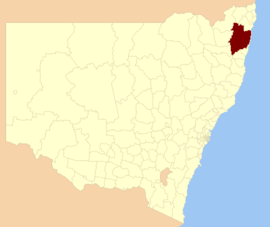
Location in New South WalesPopulation: 52,054(2009)[1] Area: 10441 km² (4,031.3 sq mi) Mayor: Richie Williamson Council Seat: Grafton (2 Prince Street) Region: Northern Rivers State District: Clarence Federal Division: Page, Cowper LGAs around Clarence Valley: Tenterfield Richmond Valley Pacific Ocean Glen Innes Severn Clarence Valley Pacific Ocean Guyra Bellingen Coffs Harbour Clarence Valley Council is a Local Government Area (LGA) in northern New South Wales. It was formed in February 2004 by the amalgamation of the LGAs of City of Grafton and Maclean Shire, and parts of Copmanhurst, Pristine Waters and Richmond Valley LGAs. It is on the Pacific Highway, the Gwydir Highway and the North Coast railway line.
The Clarence Valley region includes the coastal plain and lower valleys of the Clarence River and Nymboida River. Most of the valley is agricultural, however the oceanside towns of Yamba and Iluka are popular holiday resorts.[2]
Contents
Towns and localities
- Alumy Creek
- Carrs Creek
- Carrs Island
- Grafton
- Great Marlow
- Junction Hill
- Koolkhan
- Mountain View
- Rushforth
- South Grafton
- Southampton
- Trenayr
- Waterview
- Waterview Heights
- Lower Clarence
- Rural
- Banyabba
- Billys Creek
- Brooms Head
- Clouds Creek
- Coaldale
- Copmanhurst
- Coutts Crossing
- Diggers Camp
- Eatonsville
- Glenferneigh
- Glenreagh
- Gurranang
- Kungala
- Lanitza
- Minnie Water
- Nymboida
- Sandon
- Seelands
- Stockyard Creek
- Tullymorgan
- Wooli
- Woombah
Demographics
In the 2006 Census of Population and Housing there were 48,145 usual residents living in Clarence Valley Council. Of this count, 23,875 (or 50%) were males and 24,271 (or 50%) were females.
By age, 20% of the population was under 15 years old, 61% were between 15 and 65, and 19% were over 65 years old.
Most people living in Clarence Valley Council were born in Australia (88%). The median age was 44 years.
Economy
According to the 2006 Census of Population and Housing, the median invididual income was $333 per week (equal to approximately $17,364 per year). The median family income in 2006 was $781 per week (equal to approximately $40,724 per year); and, the median household income in 2006 was $631 per week (equal to approximately $32,902 per year).
There were 16,929 people employed in 2006 (to give an employment to working age population ratio of 0.58), and 1,868 people unemployed. The most common occupations were Labourers (15%); Technicians and Trades Workers (14%); and, Professionals (14%). The top 5 industries for employment were School Education (5.3%); Cafes, Restaurants and Takeaway Food Services (3.3%); Hospitals (3.2%); Sheep, Beef Cattle and Grain Farming (3.2%); and, Local Government Administration (3.0%).
Housing
In the 2006 Census of Population and Housing, the median housing loan repayment was $953 per month. This equated to marginally under 38% of median household income.
The median rent in 2006 was $150 per week. This equated to just under 24% of median household income.
The average household size was 2.4 persons.
Council
Clarence Valley Council is composed of nine councillors elected proportionally. The mayor is not directly elected.[3] The current makeup of the council is as follows:[3]
Party Councillors Independents 9 Total 9 The current council, elected in 2008, is:[3]
Councillor Party Notes Richie Williamson Independent Mayor Ian Tiley Independent Jim Simmons Independent Deputy Mayor Ian Dinham Independent Sue Hughes Independent Margaret McKenna Independent Karen Toms Independent Craig Howe Independent Patrick Comben Independent References
- ^ Australian Bureau of Statistics (30 March 2010). "Regional Population Growth, Australia, 2008–09". http://www.abs.gov.au/ausstats/abs@.nsf/Latestproducts/3218.0Main%20Features42008-09?opendocument&tabname=Summary&prodno=3218.0&issue=2008-09&num=&view=. Retrieved 3 June 2010.
- ^ "Clarence Valley Social Plan". Clarence Valley Council. Archived from the original on 2007-02-10. http://web.archive.org/web/20070210224824/http://www.clarence.nsw.gov.au/cms/res.asp?id=363. Retrieved 2006-11-19.
- ^ a b c "Clarence Valley Council". 2008 Election results. Electoral Commission NSW. http://www.lg.elections.nsw.gov.au/LGE2008/result.Clarence_Valley.html. Retrieved 2009-06-16.[dead link]
External links
Local Government Areas of New South Wales Metropolitan Sydney Inner SydneyAshfield · Botany Bay · Burwood · Canada Bay · Canterbury · Hurstville · Kogarah · Lane Cove · Leichhardt · Manly · Marrickville · Mosman · North Sydney · Randwick · Rockdale · Strathfield · Sydney · Waverley · Willoughby · WoollahraOuter SydneyAuburn · Bankstown · Blacktown · Camden · Campbelltown · Fairfield · The Hills · Holroyd · Hornsby · Hunter's Hill · Ku-ring-gai · Liverpool · Parramatta · Penrith · Pittwater · Ryde · Sutherland · WarringahSydney SurroundsMid North Coast Bellingen · Clarence Valley · Coffs Harbour · Greater Taree · Kempsey · Nambucca · Port Macquarie-Hastings · Lord Howe IslandMurray Murrumbidgee Carrathool · Coolamon · Cootamundra · Griffith · Gundagai · Hay · Junee · Leeton · Lockhart · Murrumbidgee · Narrandera · Temora · Wagga WaggaHunter Cessnock · Dungog · Gloucester · Great Lakes · Lake Macquarie · Maitland · Muswellbrook · Newcastle · Port Stephens · Singleton · Upper HunterIllawarra Richmond Tweed Southeastern Bega · Bombala · Boorowa · Cooma-Monaro · Eurobodalla · Goulburn Mulwaree · Harden · Palerang · Queanbeyan · Snowy River · Tumut · Upper Lachlan · Yass Valley · YoungNorthern Armadale Dumaresq · Glen Innes-Severn · Gunnedah · Guyra · Gwydir · Inverell · Liverpool Plains · Moree Plains · Narrabri · Tamworth · Tenterfield · Uralla · WalchaCentral West North Western Far West
Wikimedia Foundation. 2010.