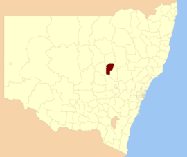
- City of Dubbo
-
Dubbo
New South Wales
Location in New South WalesPopulation: 41,211(2009)[1] Established: 1872 Area: 3425 km² (1,322.4 sq mi) Mayor: Alan Smith Council Seat: Dubbo (Church Street) Region: Orana State District: Dubbo Federal Division: Parkes LGAs around Dubbo: Narromine Gilgandra Warrumbungle Narromine Dubbo Wellington Parkes Parkes Wellington - For the seat in the New South Wales Legislative Assembly, see Electoral district of Dubbo.
Dubbo is a Local Government Area in the Orana region of New South Wales, Australia. The City is traversed by the Mitchell Highway, the Newell Highway, the Golden Highway and the Main Western railway line.
The largest population centre is the city of Dubbo. Dubbo City also includes the villages of Eumungerie, Mogriguy, Brocklehurst, Wongarbon, Toongi, and Rawsonville.[2]
Contents
Council
The Dubbo City Council consists of eleven elected councillors who are elected for a four year term. The City is not divided into ridings or wards. Therefore, each councillor represents the whole local government area, and not a specific subsection of the City. The eleven councillors meet every year in September to elect the mayor. The mayor must be a member of council.[3].[4] The current makeup of the council is as follows:[4]
Party Councillors Independents and Unaffiliated 11 Total 11 The current council, elected in 2008, is:[4]
Councillor Party Notes Ben Shields Independent Tina Reynolds Independent Greg Matthews Unaffiliated Ann Barnard Independent Elected on Ben Shields's ticket Richard Mutton Independent Allan Smith Independent Mayor Lyn Griffiths Unaffiliated Peter Bartley Independent Matthew Dickerson Independent Rod Towney Independent Deputy Mayor Keith Harris Independent Elected on Tina Reynolds's ticket The Dubbo City Council staffs around 350 permanent employees, and is responsible for the city and surrounding areas. The Civic Administration Building is located on the corner of Darling and Church Streets and now has a "One Stop Shop" for all customers of the council.
History
The Dubbo local government area came into being on February 19, 1872, when the Municipal District of Dubbo was approved by the Colonial secretary. The first six aldermen were elected into office on April 22, 1872 with 82 votes being cast for a wide field of candidates[5].
Talbragar Shire was amalgamated with the Dubbo City Council on 1 April 1980. At that time the area of the city was 3321 square kilometres, and with a population estimated at 29,000[5].
Industry
As a regional centre, the City of Dubbo provides services far beyond its own population base. It serves 130,000 people, and one third of the geographic area of New South Wales.[2] The main industry sectors represented in the City of Dubbo are retail, health, manufacturing, transport, tourism, education, construction, business services, agriculture, and government services[2].
Sister cities
The City of Dubbo has four sister cities[6]:
 Minokamo, Japan, since 1989.
 Warringah, New South Wales, since 1994.
 Wujiang, China, since 1995.
 Newcastle, New South Wales, since 1995.
References
- ^ Australian Bureau of Statistics (30 March 2010). "Regional Population Growth, Australia, 2008–09". http://www.abs.gov.au/ausstats/abs@.nsf/Latestproducts/3218.0Main%20Features42008-09?opendocument&tabname=Summary&prodno=3218.0&issue=2008-09&num=&view=. Retrieved 3 June 2010.
- ^ a b c 2004-2005 Annual report Dubbo City Council website, accessed November 11, 2006
- ^ Councillors Dubbo City Council website, accessed November 11, 2006
- ^ a b c "Dubbo City Council". 2008 Election results. Electoral Commission NSW. http://www.lg.elections.nsw.gov.au/LGE2008/result.Dubbo.html. Retrieved 2009-06-16.[dead link]
- ^ a b History of Dubbo City Council Dubbo City Council website, accessed November 11, 2006
- ^ Dubbo Sister Cities
External links
Coordinates: 32°15′S 148°36′E / 32.25°S 148.6°E
Local Government Areas of New South Wales Metropolitan Sydney Inner SydneyAshfield · Botany Bay · Burwood · Canada Bay · Canterbury · Hurstville · Kogarah · Lane Cove · Leichhardt · Manly · Marrickville · Mosman · North Sydney · Randwick · Rockdale · Strathfield · Sydney · Waverley · Willoughby · WoollahraOuter SydneyAuburn · Bankstown · Blacktown · Camden · Campbelltown · Fairfield · The Hills · Holroyd · Hornsby · Hunter's Hill · Ku-ring-gai · Liverpool · Parramatta · Penrith · Pittwater · Ryde · Sutherland · WarringahSydney SurroundsMid North Coast Bellingen · Clarence Valley · Coffs Harbour · Greater Taree · Kempsey · Nambucca · Port Macquarie-Hastings · Lord Howe IslandMurray Murrumbidgee Carrathool · Coolamon · Cootamundra · Griffith · Gundagai · Hay · Junee · Leeton · Lockhart · Murrumbidgee · Narrandera · Temora · Wagga WaggaHunter Cessnock · Dungog · Gloucester · Great Lakes · Lake Macquarie · Maitland · Muswellbrook · Newcastle · Port Stephens · Singleton · Upper HunterIllawarra Richmond Tweed Southeastern Bega · Bombala · Boorowa · Cooma-Monaro · Eurobodalla · Goulburn Mulwaree · Harden · Palerang · Queanbeyan · Snowy River · Tumut · Upper Lachlan · Yass Valley · YoungNorthern Armadale Dumaresq · Glen Innes-Severn · Gunnedah · Guyra · Gwydir · Inverell · Liverpool Plains · Moree Plains · Narrabri · Tamworth · Tenterfield · Uralla · WalchaCentral West North Western Bogan · Bourke · Brewarrina · Cobar · Coonamble · Dubbo · Gilgandra · Narromine · Walgett · Warren · Warrumbungle · WellingtonFar West Categories:- Populated places established in 1872
- 1872 establishments in Australia
- Local Government Areas of New South Wales
- Dubbo
Wikimedia Foundation. 2010.
