- Mitchell Highway
-
Mitchell Highway _ 
Proposed _to_replace_  to replace
  [1]
[1]Length 1105 km (687 mi) Direction North-South From  Landsborough Highway,
Augathella, Queenslandvia Charleville, Cunnamulla, Bourke, Nyngan, Narromine, Dubbo, Wellington, Orange To  Great Western Highway,
Bathurst, New South WalesAllocation Augathella - Qld/NSW Border: Formerly 
Qld/NSW Border - Nyngan: Nyngan - Bathurst:Major junctions Warrego Highway
 Balonne Highway
 Kamilaroi Highway
 Kidman Way
 Barrier Highway
 Oxley Highway
 Newell Highway
 Golden Highway
 Peabody Road
 Escort Way
 Mid-Western Highway
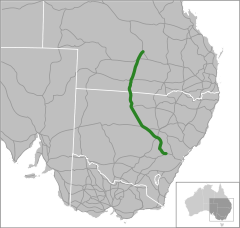
The Mitchell Highway is a major rural highway in Australia, travelling through central and northern New South Wales and south central Queensland. The highway starts from its northern end in Queensland with the Landsborough Highway near Augathella and continues south to Charleville and Cunnamulla. It then crosses the border into New South Wales and passing through Bourke, Byrock, Nyngan, Nevertire, Narromine, Dubbo, Wellington, Molong and Orange. The highway ends at the junction of the Mid-Western Highway to Cowra and the Great Western Highway to Sydney via the Blue Mountains at Bathurst.
The highway was declared on 8 August 1928 and named North Western Highway. On 9 October 1936 the name was changed to the Mitchell Highway, named after Major Thomas Mitchell, who was Surveyor-General of New South Wales in the 1820s and explored much of inland New South Wales and Victoria.[2]
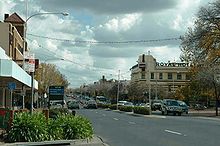
The portion of the Mitchell Highway passing through Orange, New South Wales, is known as Summer Street and serves as the main street through the city.[3]
See also
References
- ^ Alpha-Numeric Route Numbering for NSW. It is here!, Ozroads: the Australian Roads Website. Retrieved on December 29, 2007.
- ^ "Mitchell Highway (NSW)". OzRoads: The Australian Roads Website. http://www.ozroads.com.au/NSW/Highways/Mitchell/mitchell.htm. Retrieved 2008-08-14.
- ^ "Summer Street Commercial Area" (PDF). Orange City Council. Archived from the original on 2008-07-22. http://web.archive.org/web/20080722131600/http://www.orange.nsw.gov.au/files/survey/PP17SS+Summer+Street+Commercial+Area.pdf. Retrieved 2008-08-14.
 Road infrastructure in Queensland
Motorways 
National Highways Highways Balonne Highway • Barwon Highway • Brisbane Valley Highway • Burnett Highway • Bunya Highway • Capricorn Highway • Captain Cook Highway • Carnarvon Highway • Castlereagh Highway • Centenary Highway • D'Aguilar Highway • Dawson Highway • Donohue Highway • Flinders Highway • Gold Coast Highway • Gregory Highway • Isis Highway • Kennedy Highway • Leichhardt Highway • Mary Valley Highway • Mitchell Highway • Moonie Highway • Mount Lindesay Highway • Mulligan Highway • Outback Highway • Palmerston Highway • Peak Downs Highway • Wide Bay HighwayDevelopmental Roads /
Outback TracksBirdsville Track • Burke Developmental Road • Gregory Developmental Road • Gulf Developmental Road • Kennedy Developmental Road • Savannah WayProposals Categories:- Australian highways
- Australia road stubs
Wikimedia Foundation. 2010.

