- Murray Valley Highway
-
Murray Valley Highway 

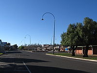
Murray Valley Highway at Nathalia Length 663 km (412 mi) Direction Northwest-Southeast From  Sturt Highway,
Euston, New South Walesvia Robinvale, Swan Hill, Kerang, Echuca, Yarrawonga, Wodonga, Tallangatta To Alpine Way,
NSW/Vic. border east of Corryong, VictoriaAllocation Sturt Highway - NSW/Vic. Border: NSW/Vic. Border - Alpine Way: Formerly

Major junctions  Mallee Highway
 Loddon Valley Highway
 Northern Highway
 Goulburn Valley Highway
 Hume Freeway
 Kiewa Valley Highway
 Omeo Highway
for full list see major intersections
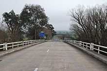 The end of the Murray Valley Highway at the Bringenbrong Bridge near Corryong
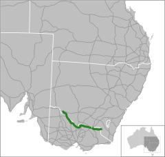
The Murray Valley Highway[1][2] (
 /[3]) is a popular tourist route, which follows the south side of the Murray River in Victoria, Australia. The route effectively acts as the northern-most highway in Victoria. The western end of route B400 is the Murray River bridge at Robinvale, although the Murray Valley Highway crosses that bridge as National Route 16 to connect with the Sturt Highway 2 km further north. Historically, the Murray Valley Highway continued west to connect with the Calder Highway at Hattah instead of crossing the river. The eastern end is in the foothills of the Great Dividing Range at Corryong. There has also been a contemporary re-alignment of the Eastern end; whereby the highway used to go through Thologogong, Walwa and Towong (the current 'Murray River Rd' C546). The route also extends further east and crosses the border into New South Wales as the Alpine Way.
Most of the highway is fairly straight and flat, much of it through irrigated farmland. It becomes hillier and more winding east of Wodonga, with a moderately steep mountain pass near Koetong, between Tallangatta and Corryong.
The major towns along the route are Robinvale, Swan Hill, Kerang, Cohuna, Echuca, Nathalia, Strathmerton, Cobram, Yarrawonga, Rutherglen, Wodonga, Tallangatta and Corryong.
Contents
Major intersections and towns
Murray Valley Highway Northbound Distance to
Mildura
(km)Distance to
Melbourne
(km)Southbound  T-intersection (clockwise from highway)
Sturt Highway to Mildura, Renmark and Adelaide
Sturt Highway to Balranald, Hay and SydneyEnd Murray Valley Highway 81 475 Start Murray Valley Highway Start 84 472 End MURRAY RIVER MURRAY RIVER NEW SOUTH WALES
STATE BORDER
VICTORIAEnd 84 472 Start Robinvale 85 471 Robinvale Manangatang, Sea Lake
Robinvale-Sea Lake Road _
87 469 Manangatang, Sea Lake
Robinvale-Sea Lake Road _ Hattah
Hattah-Robinvale Road _
102 454 Hattah
Hattah-Robinvale Road _ continues as 175 381 Tooleybuc, Balranald, Sydney
Tooleybuc Road
Tooleybuc, Balranald, Sydney
Tooleybuc Road duplexes with duplexes with 177 379 Ouyen, Adelaide
Mallee Highway Ouyen, Adelaide
Mallee Highway continues as Nyah 192 364 Nyah PIANGIL RAIL LINE

217 339 PIANGIL RAIL LINE
Northbound Distance to
Swan Hill
(km)Distance to
Melbourne
(km)Southbound Town Centre, Sea Lake
Sea Lake-Swan Hill Road
Moulamein, Deniliquin
Moulamein Road _ 
0 337 Swan Hill Swan Hill Moulamein, Deniliquin
Moulamein Road
Town Centre, Sea Lake
Sea Lake-Swan Hill Road _ Wycheproof, Donald
Donald-Swan Hill Road _
5 332 Wycheproof, Donald
Donald-Swan Hill Road _ SWAN HILL RAIL LINE
9 328 SWAN HILL RAIL LINE
Lake Boga 16 321 Lake Boga SWAN HILL RAIL LINE
53 284 SWAN HILL RAIL LINE
To  Boort; Quambatook, Donald
Kerang-Quambatook Road _
57 280 To Boort; Quambatook, Donald
Kerang-Quambatook Road _ To  Murrabit; Town Centre, Koondrook
Kerang-Koondrook Road _
59 278 Kerang Kerang To Murrabit; Town Centre, Koondrook
Kerang-Koondrook Road _ Bendigo, Melbourne
Loddon Valley Highway
62 275 Bendigo, Melbourne
Loddon Valley Highway Westbound Distance to
Swan Hill
(km)Distance to
Echuca
(km)Eastbound SWAN HILL RAIL LINE
63 89 SWAN HILL RAIL LINE
Koondrook, Barham
Cohuna-Koondrook Road _
89 63 Koondrook, Barham
Cohuna-Koondrook Road _ Leitchville
Cohuna-Leitchville Road _
91 61 Cohuna Cohuna Leitchville, Pyramid Hill
Cohuna-Leitchville Road _ Leitchville, Pyramid Hill
Kerang-Leitchville Road _
106 46 Leitchville, Pyramid Hill
Kerang-Leitchville Road _ Town Centre, Moama
Warren Street _
152 0 Echuca Town Centre, Moama
Warren Street _ Westbound Distance to
Swan Hill
(km)Distance to
Wodonga
(km)Eastbound continues as 153.5 236.1 Rochester, Bendigo, Melbourne
Northern Highway
Rochester, Bendigo, Melbourne
Northern Highway duplexes with duplexes with 155.3 234.3 Town Centre, Moama, Deniliquin
Northern Highway 
Town Centre, Moama, Deniliquin
Northern Highway continues as ECHUCA RAIL LINE
155.6 234 ECHUCA RAIL LINE
Westbound Distance to
Echuca
(km)Distance to
Wodonga
(km)Eastbound Kyabram
Echuca-Kyabram Road _
0 233 Kyabram
Echuca-Kyabram Road _ Echuca Tongala, Kyabram
Kyabram-Tongala Road _
18 215 Tongala, Kyabram
Kyabram-Tongala Road _ Kyabram
John Allen Road _
28 205 Kyabram
John Allen Road _ To  Tatura; Shepparton
Echuca-Mooroopna Road _
30 203 To Tatura; Shepparton
Echuca-Mooroopna Road _ GOULBURN RIVER 36 197 GOULBURN RIVER Shepparton, Barmah
Barmah-Shepparton Road _
51 182 Barmah, Shepparton
Barmah-Shepparton Road _ Numurkah, Katamatite
Katamatite-Nathalia Road _
54 179 Numurkah, Katamatite
Katamatite-Nathalia Road _ Nathalia 55 178 Nathalia continues as 89 144 Numurkah, Shepparton, Melbourne
Goulburn Valley Highway
Numurkah, Shepparton, Melbourne
Goulburn Valley Highway duplexes with Strathmerton 93 140 Strathmerton TOCUMWAL RAIL LINE
94 139 TOCUMWAL RAIL LINE
duplexes with 103.2 129.8 Tocumwal, Finley, Brisbane
Goulburn Valley Highway Tocumwal, Finley, Brisbane
Goulburn Valley Highway continues as Benalla
Benalla-Tocumwal Road _
103.3 129.7 Katamatite, Benalla
Benalla-Tocumwal Road _ Katamatite, Benalla
Cobram South Road _
107 126 Benalla
Cobram South Road _ To  Barooga; Town Centre, Tocumwal
Cobram-Koonoomoo Road _
108 125 Cobram Cobram To Barooga; Town Centre, Tocumwal
Cobram-Koonoomoo Road _ COBRAM RAIL LINE
108.1 124.9 COBRAM RAIL LINE
continues as 143.8 89.2 To Katamatite; Benalla
Benalla-Yarrawonga Road _
To Katamatite; Benalla
Benalla-Yarrawonga Road _ _duplexes_with_ duplexes with OAKLANDS RAIL LINE
144 89 OAKLANDS RAIL LINE
_duplexes_with_ duplexes with 145 88 Yarrawonga Town Centre, Mulwala, Corowa
Belmore Street _ Town Centre, Mulwala, Corowa
Belmore Street _ Yarrawonga continues as Wangaratta
Wangaratta-Yarrawonga Road _
164 69 Wangaratta
Wangaratta-Yarrawonga Road _ Wangaratta, Corowa
Three Chain Road _
186 47 Wahgunyah, Corowa, Wangaratta
Three Chain Road _ continues as 190 43 Rutherglen Wahgunyah, Corowa
Rutherglen-Wahgunyah Road _
Wahgunyah, Corowa
Rutherglen-Wahgunyah Road _ _duplexes_with_ duplexes with _duplexes_with_ duplexes with 191 42 Springhurst, Chiltern
Chiltern-Rutherglen Road __ _
Springhurst, Chiltern
Chiltern-Rutherglen Road __ _ Rutherglen continues as WAHGUNYAH RAIL LINE
191.1 41.9 WAHGUNYAH RAIL LINE
Chiltern, Howlong
Chiltern-Howlong Road _
206 27 Howlong, Chiltern
Chiltern-Howlong Road _ Howlong
Barnawartha-Howlong Road _
212 21 Howlong
Barnawartha-Howlong Road _ NORTH EAST RAIL LINE 217.4 15.6 NORTH EAST RAIL LINE Murray Valley Highway
continues from Hume Freeway
217.5 15.5 Wangaratta, Seymour, Melbourne
Hume Freeway 
continues as Hume Freeway
to WodongaWestbound Distance to
Melbourne
(km)Distance to
Corryong
(km)Eastbound continues as Hume Freeway
to Melbourne319 123 Murray Valley Highway
duplexes with Old Hume Highway
and continues from Hume Freeway Albury
Old Hume Highway
Sydney
Hume Freeway _duplexes_with_ duplexes with 320 122 Wodonga Town Centre, Beechworth
Old Hume Highway Town Centre, Beechworth
Old Hume Highway Wodonga continues as NORTH EAST RAIL LINE
321 121 NORTH EAST RAIL LINE
Albury, Sydney
Bandiana Link _
324 118 Albury, Sydney
Bandiana Link _ Mount Beauty, Falls Creek
Kiewa Valley Highway _
326 116 Mount Beauty, Falls Creek
Kiewa Valley Highway _ Hume Dam
Bonegilla Road _
333 109 Hume Dam
Bonegilla Road _ To  Dartmouth, Omeo; Tangambalanga
Kiewa East Road _
349 93 Tangambalanga, Yackandandah
Kiewa East Road _ Tallangatta 361 81 Tallangatta Omeo, Bairnsdale
Omeo Highway _
367 75 Omeo, Bairnsdale
Omeo Highway _ Granya
Murray River Road _
377 65 Granya
Murray River Road _ Walwa, Jingellic
Shelley-Jingellic Road _
404 38 Walwa, Jingellic
Shelley-Jingellic Road _ Cudgewa, Tintaldra
Cudgewa-Tintaldra Road _
425 17 Cudgewa, Tintaldra
Cudgewa-Tintaldra Road _ Benambra, Omeo, Mount Hotham, Bairnsdale
Benambra-Corryong Road _
435 7 Benambra, Omeo
Benambra-Corryong Road _ Corryong 442 0 Corryong Westbound Distance to
Melbourne
(km)Distance to
Jindabyne
(km)Eastbound Towong, Tintaldra
Murray River Road _ 449 129 Towong, Tintaldra
Murray River Road _ Start Murray Valley Highway
from Alpine Way456 122 End Murray Valley Highway VICTORIA
STATE BORDER
NEW SOUTH WALESMURRAY RIVER 456 122 MURRAY RIVER continues as Alpine Way
to Jindabyne / CoomaSource
Murray Valley Highway on Google Maps
See also
- Highways in Australia
- Highways in Victoria
References
- ^ Australian Towns, Cities & Highways: Murray Valley Highway, Hotkey. Retrieved on 11 May 2008.
- ^ Murray Valley Highway, ExplorOz. Retrieved on 11 May 2008.
- ^ Ozroads: National Route 16, Ozroads: the Australian Roads Website. Retrieved on 11 May 2008.
 Road infrastructure in Victoria
Freeways 
Highways Bass Highway • Bellarine Highway • Borung Highway • Calder Highway • Glenelg Highway • Goulburn Valley Highway • Hamilton Highway • Henty Highway • Hopkins Highway • Kiewa Valley Highway • Loddon Valley Highway • Mallee Highway • Maroondah Highway • Melba Highway • Midland Highway • Monaro Highway • Murray Valley Highway • Nepean Highway • Northern Highway • Omeo Highway • Princes Highway • Pyrenees Highway • South Gippsland Highway • Strzelecki Highway • Sturt Highway • Sunraysia Highway • Surf Coast Highway • Warburton Highway • Western Highway • Western Port Highway • Wimmera HighwayBypass routes Old Hume Highway • Old Princes Highway • Princes Highway (Geelong)Tourist routes Categories:- Australian highways
- Highways in Victoria (Australia)


Wikimedia Foundation. 2010.