- Northern Highway, Victoria
-
Northern Highway 
Formerly 
Length 164 km (102 mi) Direction North-South From Cobb Highway, Moama, NSW / Echuca, Victoria (NSW/Vic Border)via Elmore, Heathcote, Kilmore To  Hume Freeway, Wallan, Victoria
Major junctions  Murray Valley Highway
 Midland Highway
 McIvor Highway
for full list see major intersections
 The Northern Highway B75, through Heathcote, Rochester and Echuca
The Northern Highway
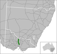
 is a secondary highway in northern Victoria. Along with the M/A79 Calder Highway (Melbourne to Mildura) and the M/A39 Goulburn Valley Highway (Melbourne to Tocumwal), it provides primary arterial links in the region. In conjunction with the B280 McIvor Highway, the B75 Northern Highway provides an important link between Melbourne and Bendigo.
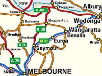
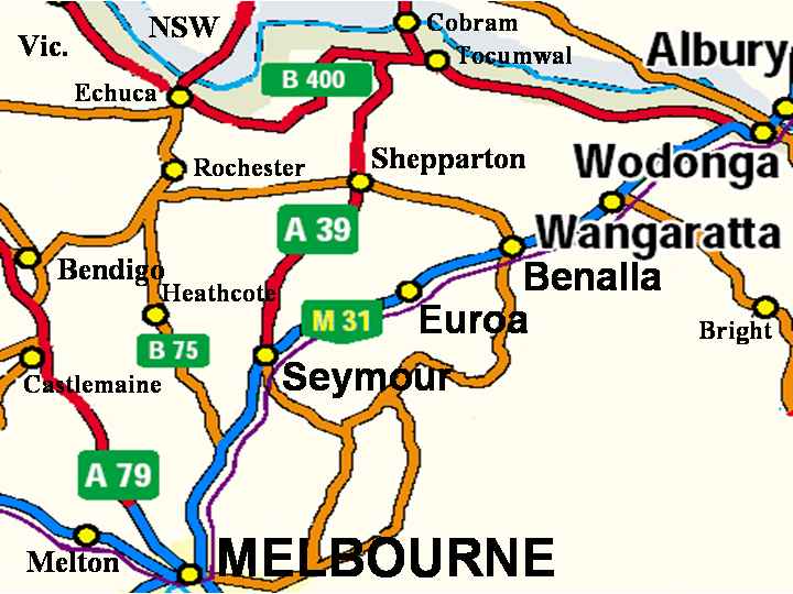
It runs from the M31 Hume Freeway south of Wallan to the New South Wales Border at Echuca, on the banks of the Murray River, a distance of 164 kilometres. The highway traverses moderately hilly terrain from Wallan to Toolleen, then flat open country to the border at Echuca. Beyond Echuca across the NSW border it continues as Cobb Highway. The section between the Hume Highway south of Wallan and the intersection of the highway and the Kilmore-Broadford Rd was, in fact, the Hume Highway until 1976, when the Hume Freeway replaced the old highway and bypassed Wallan, Kilmore and Broadford.
The Northern Highway and the beginning of the McIvor Highway form a junction at Heathcote. The McIvor Highway leads to Bendigo and the Northern Highway continues to Echuca.
The B75 Northern Highway is a significant freight route providing access to markets, airport and port in Melbourne and the rural primary production areas of the Murray Valley and southern New South Wales. It serves a number of agricultural and tourism-related industries along its length.
Contents
Major intersections and towns
Northern Highway 
Northbound Distance to
Echuca
(km)Distance to
Melbourne
(km)Southbound End Northern Highway 
continues as Cobb Highway
to Deniliquin / Hay / Wilcannia-- 221 Start Northern Highway
from Cobb HighwayMURRAY RIVER MURRAY RIVER NEW SOUTH WALES
STATE BORDER
VICTORIATo  Cohuna, Kerang
High Street _

-- 220.5 To Cohuna, Kerang
High Street _ Echuca 0 220 Echuca continues as 1 219 Nathalia, Yarrawonga, Wodonga; To  Kyabram
Murray Valley Highway 
Nathalia, Yarrawonga, Wodonga
Murray Valley Highway duplexes with duplexes with 3 217 Cohuna, Kerang, Swan Hill
Murray Valley Highway Cohuna, Kerang, Swan Hill
Murray Valley Highway continues as Mitiamo
Echuca-Mitiamo Road _

8 212 Mitiamo
Echuca-Mitiamo Road _ Prairie
Prairie-Rochester Road _
22 198 Prairie
Prairie-Rochester Road _ ECHUCA RAIL LINE

27.5 192.5 ECHUCA RAIL LINE
Kyabram
Kyabram-Rochester Road _
28 192 Rochester Rochester Kyabram; To  Rushworth
Kyabram-Rochester Road _ Raywood
Elmore-Raywood Road _
45.5 174.5 Raywood
Elmore-Raywood Road _ Elmore 46 174 Elmore continues as Bendigo, Ballarat
Midland Highway
Bendigo
Midland Highway duplexes with duplexes with 48 172 Shepparton, Benalla
Midland Highway Shepparton, Benalla
Midland Highway continues as Bendigo, Rushworth, Murchison
Bendigo-Murchison Road _
59 161 Rushworth, Murchison, Bendigo
Bendigo-Murchison Road _ Rushworth, Murchison
Heathcote-Rochester Road _ 84 136 Rushworth
Heathcote-Rochester Road _ Bendigo
McIvor Highway
95 125 Bendigo
McIvor Highway Redesdale, Kyneton
Heathcote-Kyneton Road _
96 124 Redesdale, Kyneton
Heathcote-Kyneton Road _ Heathcote 97 123 Heathcote Nagambie
Heathcote-Nagambie Road _
101 119 Nagambie
Heathcote-Nagambie Road _ Puckapunyal, Seymour
Seymour-Tooborac Road _
112.5 107.5 Puckapunyal, Seymour
Seymour-Tooborac Road _ Tooborac 113 107 Tooborac Lancefield, Sunbury
Lancefield-Tooborac Road _

114 106 Lancefield, Romsey, Sunbury
Lancefield-Tooborac Road _ Broadford, Seymour
Broadford-Kilmore Road _
144 76 Broadford
Broadford-Kilmore Road _ Kilmore 146 74 Kilmore Lancefield, Woodend
Kilmore-Lancefield Road _
147 73 Lancefield, Woodend
Kilmore-Lancefield Road _ Wandong, Epping
Epping-Kilmore Road _
150 70 Wandong, Whittlesea, Epping
Epping-Kilmore Road _ Wallan 159 61 Wallan Seymour, Sydney via  Freeway;
Whittlesea, Kinglake
Wallan-Whittlesea Road
160 60 Seymour, Sydney via Freeway;
Whittlesea, Kinglake
Wallan-Whittlesea Road Start Northern Highway
from Hume Freeway164 56 End Northern Highway
continues as Hume Freeway
to MelbourneAttractions
- Heathcote-Graytown National Park
See also
- Highways in Australia
- Highways in Victoria
References
- Northern Highway (B75), Melway Street Directory 2008, Edition 35, page 909.
 Road infrastructure in Victoria
Freeways 
Highways Bass Highway • Bellarine Highway • Borung Highway • Calder Highway • Glenelg Highway • Goulburn Valley Highway • Hamilton Highway • Henty Highway • Hopkins Highway • Kiewa Valley Highway • Loddon Valley Highway • Mallee Highway • Maroondah Highway • Melba Highway • Midland Highway • Monaro Highway • Murray Valley Highway • Nepean Highway • Northern Highway • Omeo Highway • Princes Highway • Pyrenees Highway • South Gippsland Highway • Strzelecki Highway • Sturt Highway • Sunraysia Highway • Surf Coast Highway • Warburton Highway • Western Highway • Western Port Highway • Wimmera HighwayBypass routes Old Hume Highway • Old Princes Highway • Princes Highway (Geelong)Tourist routes Categories:- Australian highways
- Highways in Victoria (Australia)

Wikimedia Foundation. 2010.