- Western Freeway (Victoria)
-
Western Freeway 
Formerly 
Length 125 km (78 mi) Direction West-East From  Western Highway, Burrumbeet, Victoria
Major suburbs Ballarat, Ballan, Bacchus Marsh, Melton, Rockbank To  Western Ring Road, Derrimut, Melbourne
Allocation National Route M8 Major junctions  Sunraysia Highway
 Midland Highway
 Melton Highway
 Ballarat Road
for full list see exits and Intersections.
See also: Western Highway, Victoria and Ballarat Road, MelbourneThe Western Freeway is a 125 kilometre Australian freeway linking the state capital of Victoria (Melbourne) to the major regional city of Ballarat. Signed as M8, it used to branch off from the Western Highway (having come originally beyond the Victorian/South Australian border outside Adelaide) at Burrumbeet, 22 kilometres north-west of Ballarat, and now ends officially to Melbourne's freeway network via the Western Ring Road, in the middle western suburbs of Melbourne. Both the freeway and Western Highway beyond Ballarat are part of the National Highway network for the Melbourne-Adelaide route.
Plans are underway for the freeway to be extended west to Ararat, and eventually, to Stawell.
The Western Freeway subsumes and bypasses most sections of the older Western Highway. Former bypassed sections of the Western Highway are generally designated sequentially from C801 to C805, or Metropolitan Route 8 (although oddly enough, this used to still keep the old National Route 8 shield) (within suburban Melbourne).
The Melbourne section of the Western Highway is shown in the 1969 Melbourne Transportation Plan as part of the F12 Freeway corridor.
Contents
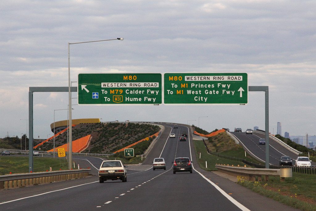
Deer Park Bypass
 Eastbound on the Deer Park Bypass approaching the Western Ring Road interchange
The Deer Park Bypass opened on 5 April 2009 in the western suburbs of Melbourne. The freeway links the Western Freeway at Ravenhall, and the Western Ring Road in Derrimut. This 9.3 kilometre freeway was estimated to cost A$333 million which also includes a grade separated interchange or a "full diamond" at Leakes Road in Rockbank.
History
The purpose of the freeway bypass is to move traffic off Ballarat Road, which leads to the Western Ring Road. Due to the strong population growth of about 8.7 per cent and subdivision in Deer Park and Sunshine, the surrounding suburbs and the seven traffic signals between the Western Ring Road and the start of the Western Freeway, substantial long and very frustrating delays were created for the 70,000 vehicles per day with 10 per cent of this consisting of heavy vehicles.
The bypass had been proposed since the completion of the Western Ring Road, the project stalled due to funding quarrels between the Federal and State Governments. In 2004, the Federal government announced that the Deer Park Bypass would be built as part of a $1.4 billion project "package grant" to Victoria (Australia). It was anticipated that more than 15 min of travel time would be saved when travelling through Deer Park, via Ballarat Road.
Construction started on the Deer Park bypass in August 2006, work being carried out as a joint venture by Leighton Contractors and VicRoads, in construction with two contracts. The first stage opened in December 2007.[1]
Opening brought forward
It was announced on 4 March 2009 that the Deer Park Bypass would open in early April 2009, with the new freeway link on track to open more than eight months ahead of schedule.
On that day, Roads and Ports Minister Tim Pallas and Federal Member for Gorton Brendan O'Connor MP inspected works from the new bridge over the Ring Road at Sunshine West and Tim Pallas announced that the $331 million Deer Park Bypass would open to the public on Sunday 5 April 2009.[2]
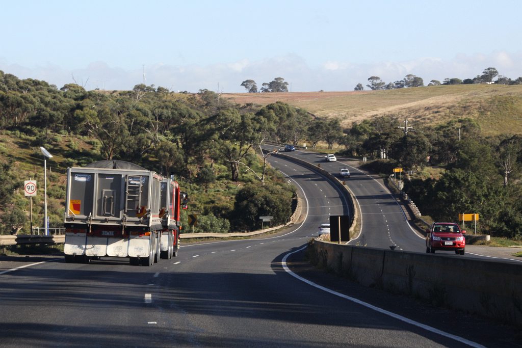
Anthony's Cutting Realignment
 Alignment of the road over Djerriwarrh Creek, before the opening of the Anthony's Cutting Realignment
The section of road through Anthony's Cutting between Bacchus Marsh and Melton was one of the most dangerous sections of the route, and was not of modern freeway standard. The steep hills and tight curves along the 5 kilometre long stretch of road resulted in 21 serious crashes in the five years to 2010.[3] More than 29,000 vehicles per day, including more than 4000 freight vehicles, travel the highway section daily.[4] The new route opened to traffic on 27 June 2011, nine months ahead of schedule.[5]
The project included:[6]
- Extension of Woolpack Road north from Bacchus Marsh Road to a new interchange on the Western Freeway, including a bridge over the Lerderderg River.
- An overpass carrying Bulmans Road over the existing Western Freeway.
- An overpass taking Hopetoun Park Road across the new freeway, with Melbourne-bound on and off ramps.
- Freeway bridges spanning Djerriwarrh Creek, and Cowans Road / Pyrites Creek.
The original project scope included a diamond interchange at Bulmans Road that has not been built, while the ramps at Hopetoun Park Road were not included but was later added.[7] The extension of Woolpack Road has been delayed due to need to clear trees in the heritage listed Avenue of Honour at Bacchus Marsh.[8]
Realignment of the road through this section had been proposed far back as 2001, when a group of 10 local councils said the realignment could cost just $65 million to build.[9] By 2006 the cost was estimated to be $85 million, with federal Roads Minister Jim Lloyd stating that the project would receive serious consideration for funding in the 2009 AusLink document, subject to support from the State Government.[10] Construction commenced in February 2010, funded by $160 million from the Australian Government and $40 million from the Victorian Government.[11]
Future upgrades
 Approximate road distances (in kilometres) of towns along the freeway
There are still several at-grade intersections on the "freeway", particularly in the areas near Rockbank and at Woodmans Hill just to the east of Ballarat.
- Proposed upgrade and safety improvements Rockbank to Melton, to be funded by Auslink 2 (2009–2014)[1].
- Proposed extension west through Ararat and eventually to Stawell, also part of Auslink 2.
Towns
Towns along the way include:
- Ballarat
- Bungaree
- Ballan
- Bacchus Marsh
- Melton
- Rockbank
Exits and Intersections
Western Freeway 
Westbound exits / intersections 
Distance to
Adelaide
(km)Distance to
Melbourne
(km)Eastbound exits / intersections End Western Freeway 
continues as Western Highway
to Horsham / Adelaide586 143 Start Western Freeway
from Western HighwayWendouree, Ballarat
Old Western Highway _
WESTERN RAIL LINE 592 137 WESTERN RAIL LINE Avoca, Mildura
Sunraysia Highway
600 129 Avoca, Mildura
Sunraysia HighwayBallarat, Maryborough
Ballarat-Maryborough Road
602 127 Maryborough, Ballarat
Ballarat-Maryborough RoadWendouree, Clunes
Gillies Street
604 125 no exit Geelong, Bendigo
Midland Highway

606 123 Bendigo, Geelong
Midland Highway Brown Hill, Daylesford
Ballarat-Daylesford Road
612 117 Daylesford, Brown Hill
Ballarat-Daylesford RoadBallarat
Ballarat-Burrumbeet Road614 115 no exit Clarks Road 615 114 no intersection Brewery Tap Road 617 112 Brewery Tap Road Mount Edgerton
Old Melbourne RoadMount Edgerton
Old Melbourne RoadGreene Road 618 111 no intersection no intersection 619 110 Richards Road Forbes Road / Black Swamp Road 621 108 Black Swamp Road / Forbes Road Bungaree
Bungaree-Wallace Road _
624 105 Bungaree
Bungaree-Wallace Road _ Bungaree, Creswick
Bungaree-Creswick Road
626 103 Creswick, Bungaree
Bungaree-Creswick RoadWallace, Springbark
Bungaree-Wallace Road /
Ormond Road632 97 Springbark, Wallace
Ormond Road /
Bungaree-Wallace RoadGordon
Brougham Street / Abbington Park Road637 92 Gordon
Brougham Street / Abbington Park RoadBallan, Daylesford
Ballan-Daylesford Road
647 82 Daylesford, Ballan
Ballan-Daylesford RoadBP SERVICE CENTRE 650 79 BP SERVICE CENTRE Ballan
Old Melbourne Road
652 77 Ballan
Old Melbourne RoadKyneton
Greendale-Myrniong Road
658 71 Kyneton
Greendale-Myrniong RoadPentland Hills
Pentland Hills Road664 65 Pentland Hills
Pentland Hills RoadPentland Hills
Mortons Road / Pentland Hills Road667 62 no exit no exit 669 60 Bacchus Marsh
Bacchus Marsh Road
Geelong, Gisborne
Bacchus Marsh-Gisborne Road
671 58 Gisborne, Geelong
Bacchus Marsh-Gisborne Road Bacchus Marsh
Bacchus Marsh Road676 53 Bacchus Marsh
Bacchus Marsh RoadHopetoun Park
Hopetoun Park Road678 51 no exit Exford, Melton
Coburns Road
684 45 Melton, Exford
Coburns RoadMelton South, Gisborne
Ferris Road /
Melton Highway
687 42 Taylors Lakes, Melton South
Melton Highway /
Ferris RoadMount Cottrell, To Beattys Road
Mount Cottrell Road689 40 To Beattys Road, Mount Cottrell
Mount Cottrell RoadPaynes Road 691 38 Paynes Road Rockbank, Plumpton
Leakes Road693 36 Plumpton, Rockbank
Leakes RoadTroups Road North 696 33 Troups Road North Werribee, Diggers Rest
Hopkins Road
698 31 Diggers Rest, Werribee
Hopkins Road Mobil SERVICE CENTRE no exit 701 28 Deer Park, Sunshine
Ballarat Road
Caroline Springs
Christies Road702 27 no exit WESTERN RAIL LINE 705 24 WESTERN RAIL LINE Tarneit, Burnside
Robinsons Road708 21 Burnside, Tarneit
Robinsons Road710 19 Greensborough, Seymour, Sydney
Western Ring Road
Laverton, Ardeer
Fitzgerald Road711 18 End Western Freeway
continues as Western Ring Road
to Melbourne / GeelongStart Western Freeway
continues from Western Ring Road References
- ^ First milestone reached on the Deer Park Bypass
- ^ Media Release - Deer Park ByPass to open in early April 2009
- ^ "$200 Million Anthony's Cutting Project Underway". Media release issued by the Hon Kevin Rudd MP, Prime Minister; Tim Pallas, Victorian Roads Minister; and Catherine King, Member for Ballarat. 18 February 2010. http://www.minister.infrastructure.gov.au/aa/releases/2010/February/AA058_2010.htm. Retrieved 4 July 2011.
- ^ "Anthony's Cutting to open early". The Courier. 24 June 2011. http://www.thecourier.com.au/news/local/news/general/anthonys-cutting-to-open-early/2206554.aspx. Retrieved 4 July 2011.
- ^ "Anthony's Cutting realignment open to traffic". Melton Leader. 27 June 2011. http://melton-leader.whereilive.com.au/news/story/anthonys-cutting-realignment-set-to-open-tomorrow/. Retrieved 4 July 2011.
- ^ "Project Overview". Western Highway Realignment Project. http://www.whrp.com.au/Documents.asp?ID=12256&Title=Project+Overview. Retrieved 4 July 2011.
- ^ "Angry Hopetoun Park residents petition MP". Melton Leader. 3 October 2009. http://melton-leader.whereilive.com.au/news/story/angry-hopetoun-park-residents-petition-mp/. Retrieved 4 July 2011.
- ^ Carolyn Webb (13 August 2010). "Heritage listing puts project on hold". The Age. http://www.theage.com.au/victoria/heritage-listing-puts-project-on-hold-20100812-121i7.html. Retrieved 4 July 2011.
- ^ MARIZA FIAMENGO (31 October 2001). "Campaign unveiled for safe highway". The Courier. http://www.thecourier.com.au/news/local/news/general/campaign-unveiled-for-safe-highway/172038.aspx. Retrieved 4 July 2011.
- ^ "Positive response to highway upgrade plan". The Courier. 31 Jul 2009. http://www.thecourier.com.au/news/local/news/columns/positive-response-toh-ighway-upgrade-plan/659545.aspx. Retrieved 4 July 2011.
- ^ "Western Highway - Realignment of Anthonys Cutting between Melton and Bacchus Marsh". nationbuildingprogram.gov.au. 18 May 2011. http://www.nationbuildingprogram.gov.au/projects/ProjectDetails.aspx?Project_id=033230-08VIC-NP. Retrieved 4 July 2011.
See also
 Road infrastructure in Victoria
Freeways 
Highways Bass Highway • Bellarine Highway • Borung Highway • Calder Highway • Glenelg Highway • Goulburn Valley Highway • Hamilton Highway • Henty Highway • Hopkins Highway • Kiewa Valley Highway • Loddon Valley Highway • Mallee Highway • Maroondah Highway • Melba Highway • Midland Highway • Monaro Highway • Murray Valley Highway • Nepean Highway • Northern Highway • Omeo Highway • Princes Highway • Pyrenees Highway • South Gippsland Highway • Strzelecki Highway • Sturt Highway • Sunraysia Highway • Surf Coast Highway • Warburton Highway • Western Highway • Western Port Highway • Wimmera HighwayBypass routes Old Hume Highway • Old Princes Highway • Princes Highway (Geelong)Tourist routes Categories:- Highways and freeways in Melbourne
- Australian highways

Wikimedia Foundation. 2010.