- Highway 1 (Australia)
-
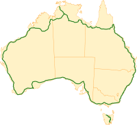 Map of Australia's Highway 1
Australia's Highway 1 is a network of highways that circumnavigate the Australian continent, joining all mainland state capitals. At a total length of approximately 14,500 km (9,000 mi) it is the longest national highway in the world, longer than the Trans-Siberian Highway (over 11,000 km, 6,800 mi) and the Trans-Canada Highway (8,030 km, 4,990 mi). Every day more than a million people travel on some part of it.[citation needed]
Contents
History
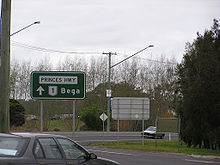
 Some sections of Highway 1 are part of the federally funded National Highway network, and thus sport this green and gold route number shield on roadside directional signage
When the National Route Numbering system was adopted in 1955, Highway 1 was the only true national highway.[citation needed] Many of the other national routes are tributaries of Highway 1.
With the introduction of the National Highway system in 1974, the significance of Highway 1 diminished, as large sections were not included in the new system. In the 1990s, Victoria and South Australia adopted alphanumeric route numbering, but retained the number 1 along the length of the highway in both states, with the letters M, A or B denoting the grade of the road.
Under the original Highway 1 scheme, certain major traffic routes that ran parallel to the main route were designated National Route Alternative 1. Most of these route designations have been replaced by either a state route designation, or an alpha-numeric route designation, depending on which state the section is in. An example of the Alternative 1 designation remaining is on the old Princes Highway route from Dandenong to South Melbourne in Victoria.
 The National Route 1 shield was once a familiar sight in all states, and can still be seen in parts of New South Wales and Western Australia, on sections that are not federally funded.
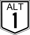 The National Route Alternative 1 shield
Track
From Sydney, it heads southwards to Melbourne and then on to Adelaide via Princes Highway. From then on to Perth via Port Wakefield Road and the Eyre Highway, Coolgardie-Esperance Highway, South Coast Highway, South Western Highway . It then heads to Darwin via Brand Highway, North West Coastal Highway, Great Northern Highway, Victoria Highway and Stuart Highway.
From Darwin, Highway 1 follows the Stuart Highway to Daly Waters, and thereafter the Carpentaria Highway to Borroloola. There is no signposted route for Highway 1 between the QLD/NT Border, east of Borroloola, and Normanton, Queensland.
From there, it follows the Gulf Developmental Road to Cairns and southwards via Bruce Highway to Brisbane and thereon back to Sydney by Pacific Highway.
In Tasmania it starts at the Brooker Highway in Hobart and heads towards Launceston via the Midland Highway. At Launceston it becomes the Bass Highway to Burnie. Highway 1 ends at Burnie; the Bass Highway continues to Marrawah on the west coast as Highway A2.
Large sections of Highway 1 are shared with the Australian National Highway, though the two are not synonymous. For instance, the Princes Highway from Sydney to Melbourne is part of Highway 1, but is not part of the National Highway, which follows the Hume Highway and Freeway.
Road conditions
With such a vast and incomparable length, road conditions vary greatly; from multi-lane freeways in populous urban and rural areas, to sealed two-laners in remote areas, such as the Nullarbor Plain, to single lane roads, such as in northern Queensland.
Some stretches are very isolated, such as the Eyre Highway, which crosses the Nullarbor Plain, and the Great Northern Highway, which runs close to the north-western coastline. Isolated roadhouses serving the small amount of passing traffic are often the only signs of human activity for hundreds of kilometres.
Sights
Highway 1 covers practically every major inhabited part of Australia. Large capital cities, busy holiday resorts, dramatic coastlines, forests ranging from tropical through to temperate gum forests and giant karri stands, scrubland, deserts and huge tropical swamps are some of the variety of landscapes that can be found along en route.
Stretches of Highway 1 are very popular with interstate and overseas tourists. A drive around Highway 1 with a major detour to Uluru and back again practically covers most of Australia. The number 1 shield became part of the bush landscape to many travellers, truckers and country people.
See also
- A1 highway (Queensland)
- A1 highway (South Australia)
- A1 highway (Victoria)
- A1 highway (Western Australia)
- List of A1 roads
- List of highways in New South Wales
- List of highways in the Northern Territory
- List of highways in Queensland
- List of highways in South Australia
- List of highways in Tasmania
- List of highways in Victoria
- List of highways in Western Australia
References
- Male, Andrew, National Highway One, Australian Broadcasting Corporation, http://www.abc.net.au/backyard/highwayone/, retrieved 2007-10-02
Categories:- Australian highways


Wikimedia Foundation. 2010.