- Monaro Highway
-
Monaro Highway 


see other route designations below
Proposed _to_replace_ to replace
  in NSW[1]
Length 286 km (178 mi) Direction North-South From  Morshead Drive,
Campbell, Australian Capital Territoryvia Tuggeranong, Michelago, Cooma, Bombala To  Princes Highway,
Cann River, VictoriaAllocation Morshead Drive - Canberra Avenue: Canberra Avenue - NSW/Vic. Border: NSW/Vic. Border - Cann River:
 Formerly

Major junctions  Canberra Avenue (Kings Highway)
 Snowy Mountains Highway
for full list see major intersections
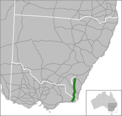
The Monaro Highway[2] is a state highway in New South Wales,[3] the Australian Capital Territory and Victoria,[4] Australia. The Victorian section was formerly known as the Cann Valley Highway until the 1980s.
The highway traverses the Monaro region, hence the name. It starts at Canberra and runs south past Michelago and Bredbo to Cooma. It continues to Nimmitabel, Bombala and beyond crossing the Victorian border until it meets Princes Highway at the town of Cann River. The Monaro Highway runs for 286 kilometres and it forms part of the main road route from Sydney to the Snowy Mountains, and to Victoria's Gippsland region (an important freight route, as an alternative to the Princes Highway).
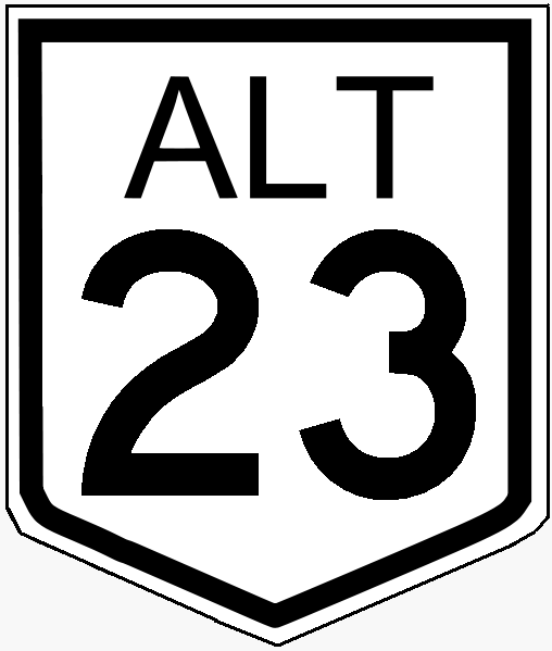
The Monaro Highway was allocated a National Route 23 shield. With Victoria's conversion to the newer alphanumeric system in the late 1990s, the Victorian section was altered to a B23 designation.
Contents
Gallery
-
The highway as it leaves Cann River
-

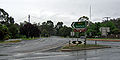
Travelling from Cooma to Canberra
Major intersections and towns
Monaro Highway __ _ 
Northbound Distance to
Sydney
(km)Distance to
Orbost
(km)Southbound  Intersection (clockwise from highway)
Morshead Drive to Russell and Canberra City Centre
Morshead Drive _to_ to Goulburn and Sydney via Federal Highway
Pialligo Drive to Canberra Airport and Queanbeyan
End Monaro Highway 287 361 Start Monaro Highway Duntroon, Canberra City Centre
Morshead Drive287.5 360.5 no intersection Fyshwick
Newcastle Street
289.5 358.5 Fyshwick
Newcastle StreetCANBERRA RAIL LINE 290 358 CANBERRA RAIL LINE Northbound Distance to
Canberra
(km)Distance to
Orbost
(km)Southbound continues as 9 357 End
continues as _
Canberra City Centre, Queanbeyan
Canberra Avenue (Kings Highway) _ 
Woden, Queanbeyan
Hindmarsh Drive10 356 To Queanbeyan, Batemans Bay; Woden
Hindmarsh DriveTo Queanbeyan, Batemans Bay
Lanyon Drive
14 352 Queanbeyan
Lanyon DriveTuggeranong
Isabella Drive
18 348 Tuggeranong
Isabella Drive_duplexes_with_ duplexes with 22 344 Theodore, Richardson, Tharwa
Johnson Drive / Tharwa Drive _ Theodore, Richardson, Tharwa
Johnson Drive / Tharwa Drive _ continues as Queanbeyan
Cooma Road30 336 Queanbeyan
Cooma RoadWilliamsdale, Burra
Williamsdale Road38 328 Williamsdale, Burra
Williamsdale RoadAUSTRALIAN CAPITAL TERRITORY
STATE BORDER
NEW SOUTH WALESMichelago
Ryrie Street54 312 Michelago
Ryrie StreetBredbo 84 282 Bredbo continues as 117 249 Cooma Jindabyne, Tumut
Snowy Mountains Highway
Jindabyne, Tumut
Snowy Mountains Highway Cooma duplexes with Nimmitabel 153 213 Nimmitabel duplexes with 163 203 Bega, Tathra
Snowy Mountains Highway Bega, Tathra
Snowy Mountains Highway continues as Dalgety, Jindabyne
Ando Road184 182 Dalgety, Jindabyne
Ando RoadMerimbula
Bombala-Cathcart Road205 161 Bombala Bombala Merimbula
Bombala-Cathcart RoadDelegate
Delegate Road207 159 Delegate
Delegate RoadEden
Nungatta Road233 133 Eden
Nungatta RoadStart 247 119 End NEW SOUTH WALES
STATE BORDER
VICTORIAEnd 
247 119 Start Start Monaro Highway 291 75 Cann River End Monaro Highway Crossroads (clockwise from highway)
Princes Highway to Genoa, Mallacoota, Eden and Sydney
Tamboon Road to Point Hicks
Princes Highway to Orbost, Bairnsdale and MelbourneSee also
- Highways in Australia
- Highways in New South Wales
- Highways in Victoria
References
- ^ Alpha-Numeric Route Numbering for NSW. It is here!, Ozroads: the Australian Roads Website. Retrieved on 25 May 2008.
- ^ National Route 23, Ozroads: the Australian Roads Website. Retrieved on 11 May 2008.
- ^ Monaro Highway, New South Wales, Hotkey. Retrieved on 11 May 2008.
- ^ Monaro Highway, Victoria, Hotkey. Retrieved on 11 May 2008.
 Road infrastructure in Canberra
Highways: 
Freeways: Bridges & tunnels: Major roads: Adelaide Avenue · Athllon Drive · Barry Drive · Belconnen Way · Canberra Avenue · Caswell Drive · Commonwealth Avenue · Constitution Avenue · Drakeford Drive · Fairbairn Avenue · Ginninderra Drive · Gungahlin Drive · Hindmarsh Drive · Isabella Drive · Kings Avenue · Limestone Avenue · Majura Road · Northbourne Avenue · Parkes Way · Tharwa Drive · William Hovell Drive · Yamba DriveInterchanges:  Road infrastructure in Victoria
Freeways Highways Bass Highway • Bellarine Highway • Borung Highway • Calder Highway • Glenelg Highway • Goulburn Valley Highway • Hamilton Highway • Henty Highway • Hopkins Highway • Kiewa Valley Highway • Loddon Valley Highway • Mallee Highway • Maroondah Highway • Melba Highway • Midland Highway • Monaro Highway • Murray Valley Highway • Nepean Highway • Northern Highway • Omeo Highway • Princes Highway • Pyrenees Highway • South Gippsland Highway • Strzelecki Highway • Sturt Highway • Sunraysia Highway • Surf Coast Highway • Warburton Highway • Western Highway • Western Port Highway • Wimmera HighwayBypass routes Tourist routes Categories:- Australian highways
- Highways in the Australian Capital Territory
- Highways in New South Wales
- Australia road stubs
-


Wikimedia Foundation. 2010.