- Highways in New South Wales
-
 New South Wales
 Highways of New South Wales
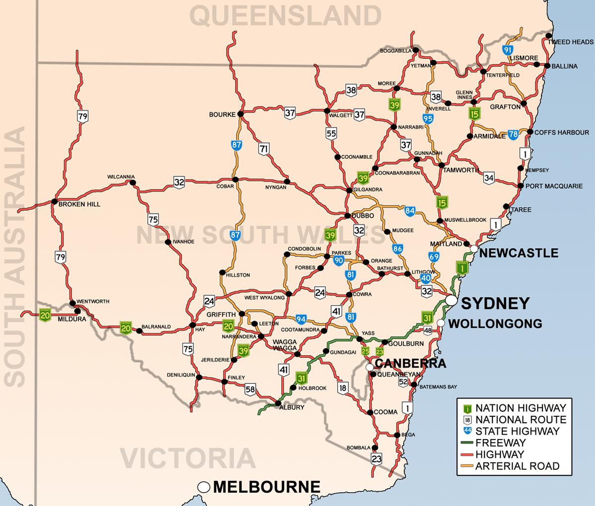
The present highway network in New South Wales, Australia was established in August 1928 when the Country Roads Board (the predecessor of the Department of Main Roads and the Roads and Traffic Authority) superseded the 1924 main road classifications and established the basis of the existing New South Wales (NSW) main road system. (the full list of main roads gazetted appears in the NSW Government Gazette of 17 August 1928). The number of a road for administrative purposes is not the same as the route number it carries eg. the Great Western Highway is state highway 5 for administrative purposes but is signposted as part of national route 32.)
Contents
History
While highways in many other countries are typically identified by number, highways in Australia, including New South Wales, are known mostly by names. These names typically come from 19th-century explorers, important politicians or geographic regions.
The highest class of highway in Australia are the federally funded National Highways that connect capital cities. National highways in New South Wales include the Hume Highway between Sydney and Melbourne, the New England Highway between Newcastle and Brisbane, the Newell Highway from Brisbane towards Melbourne, and the Federal and Barton Highways, which link Canberra to the Hume.
Numbering
National route numbers have been allocated to NSW highways since 1955. National Route 1 ('Highway 1') is one of the best known numbered national routes, likely because of its fame for circumnavigating the continent. National Highway 31, the Hume Highway, is another relatively well-known route number. The insignia of national routes is a five-sided black and white shield, chosen as it is the shape of the Australian national coat of arms.[citation needed] National highways use the same shield, except for their green and gold colour and the word 'national' added across the top.
To supplement the national route number system, three ring roads were introduced to Sydney in 1964.[1] These were numbered 1, 3 and 5, with relatively (but not proportionately) increasing radii. While they were officially decommissioned in 1974, some old ring road 3 signs remained posted into the 1980s, and ring road 1 signs into the 1990s.
In 1973, a system of freeway numbering was introduced to the state to complement the national routes and ring roads. The shields were replicas of the red, white and blue U.S. Interstate Highway shields, and were numbered F1 to F8. The F1 was the Warringah Freeway, the F2 reserved for the Castlereagh Freeway, a corridor similar to today's M2 Hills Motorway, the F3 is the Sydney Newcastle Freeway, the F4 was the western part of today's M4 Western Motorway (formerly Western Freeway), the F5 was the freeway section of National Highway 31, the F6 is the Southern Freeway, the F7 was reserved for a corridor similar to today's Cahill Expressway, Eastern Distributor and Bondi Junction Bypass and the F8 was a section of Wollongong's Northern Distributor,[2] now part of State Route 60. Most of these routes were replaced with other numbers over the decades, and by 1990s, only the F1, F3 and F6 were still marked as such, with simpler, green-on-white shields. None of these shields remain, but the F3 and F6 are still usually called by those names.
In 1974, the three ring roads, 1, 3 and 5, were decommissioned and replaced by new State Routes, which had the same shields as the new freeways but without the red crest. Scores of other State Routes were also designated across New South Wales, marking out urban arterial routes and secondary rural highways. They were allocated as follows:
- 11, 33 and 55: Respectively replaced ring roads 1, 3 and 5. In 1989, state route 77 was commissioned as an additional primary radial route.
- 12-76: Greater Sydney. Even numbers were spur routes while odd numbers were radial, roughly increasing in value anticlockwise around the City. Exceptions were State Route 31 (which replaced Metroad 5 when the South Western Motorway was extended easterly; Metroad 5 was a replacement of the metropolitan part of National Highway 31) and state route 60 (which is in Wollongong). Routes 36, 40, 56, 68 and 69 extended beyond the bounds of Greater Sydney. While most State Routes still appear on maps and in street directories, they were haphazardly removed and covered up in Sydney during the late 1990s, leaving only routes 29, 31, 40, 44, 54, 56, 60 and 69 reliably posted today.
- 78-99: Rural Areas. There is no discernible pattern with these routes. State route 83 was commissioned in 1979 and state route 89 was commissioned in 1980.
- 111, 121-124, 128, 131-132, 135: Greater Newcastle. 111 was added in 1988 following National Highway 1's relocation to the F3 Freeway. Many of these routes still exist today.
- 151, 153, 155 and 157: Greater Wollongong, in addition to state routes 60, 68, 69 and 88. Some of these still exist today.
- 2: In 2008, Queensland's state route 2 from the Gold Coast was extended a short distance into far northern NSW.
In 1993, Sydney's Metroad system was introduced, with its prominent, blue-on-white hexagonal shields. There were initially six metroads: Metroad 1 replaced National Route 1 within the metropolitan area, Metroad 2 replaced parts of State Routes 28 and 30 (and was subsequently absorbed by the M2 Hills Motorway), Metroad 3 replaced State Route 33 (once Ring Road 3), Metroad 4 replaced the F4 Freeway and the metropolitan part of National Route 32, Metroad 5 replaced part of the metropolitan part of National Highway 31 and Metroad 7 replaced State Route 77. Later, Metroad 6 replaced State Route 45, Metroad 9 replaced the metropolitan part of State Route 69 and Metroad 10 replaced State Route 14 south of Mona Vale. There was never a Metroad 8.
Currently, the state is preparing to replace its entire system of State Routes, National Routes, National Highways and Metroads with an alphanumeric route numbering system. Instead of shields, the numbers will be on a rectangular background outlined in white. There has as yet been no announcement for when the changeover will take place. All new highway signs have the new alphanumeric route numbers in place but obscured with a covering plate.
Types of Roads
Most NSW highways are two-lane, undivided roadways, with relatively few lengths of dual carriageway. Only relatively short lengths of the dual carriageway are true freeways with restricted access points and grade-separated interchanges. Today 90% of the New South Wales section (and 100% of the Victorian section) of the Hume Highway is dual carriageway; 100% of the Hume Highway will be dual carriageway achieved by 2012. Currently, 40% of the Pacific Highway is dual carriageway: it will be 100% dual carriageway by 2016. Dual carriageways are at the following locations; Hexham-south of Bulahdelah (north of Myall Way, construction is underway),[3] Bulahdelah bypass (planning approval granted)[4][5][6][7][8][9] , north of Bulahdelah-Coopernook (north of Coopernook-Herons Creek, construction is underway)[10] and Herons Creek-Port Macquarie,[11] Eungai Deviation 2nd Carriageway,[12] Raleigh Deviation,[13] Bonville Bypass (in construction),[14] Coffs Harbour Bypass (planning) ,[15] Ballina Bypass (pre-construction activities),[16] Bangalow Bypass Duplication[17] and between the Ewingsdale Interchange (Byron Bay exit) to Brisbane[18] (including Tugun Bypass[19] and Banora Point/Sextons Hill (undergoing EIS and SIS)[20]).
Today
New South Wales is slowly preparing to introduce an alpha-numeric route code system - new signs are being fitted with such route numbers with a coverplate carrying the existing route number being fitted over the top. There has been no announcement from the Roads and Traffic Authority of NSW yet as to when this official changeover will take place.
National Highways
 Sydney-Newcastle Freeway
 New England Highway
 Sturt Highway
 Federal Highway
 Barton Highway
 Hume Highway
 Newell Highway
National Routes and State Highways

 Murray Valley Highway
 Snowy Mountains Highway
 Monaro Highway
 Mid-Western Highway
 Oxley Highway
 Kamilaroi Highway
 Gwydir Highway
 Olympic Highway
 Bruxner Highway
 Illawarra Highway
 Kings Highway
 Castlereagh Highway
 Riverina Highway
 Mitchell Highway
 Cobb Highway
 Silver City Highway
State Routes and Major Arterial Roads

 Bells Line of Road
 Great Western Highway
 Princes Highway
 Princes Highway
 Waterfall Way
 Lachlan Valley Way
 Golden Highway
 Goldfields Way
 Castlereagh Highway
 Kidman Way
 Picton Road
- Camden Valley Way
- Remembrance Drive
 Escort Way
 Summerland Way
 Burley Griffin Way
 Fossickers Way
 Pacific Highway
Metroads
Minor Arterial Roads
- Alpine Way
- Barry Way
- Bathurst-Ilford Road
- Bucketts Way
- Bylong Valley Way
- Goulburn-Oberon Road
- Henry Lawson Way
- Irrigation Way
- Lachlan Valley Way
- O'Connell Road
- Thunderbolts Way
- Wombeyan Caves Road
- Yass Valley Way
See also
- Highways in Australia for highways in other states and territories
References
- ^ http://www.ozroads.com.au/NSW/RouteNumbering/Ring%20Roads/ringroads.htm
- ^ http://www.ozroads.com.au/NSW/Freeways/F8/f8.htm
- ^ Karuah to Bulahdelah sections 2 and 3 Abrigroup
- ^ $123 million Bulahdelah highway bypass approved Manning River Times, 27 July 2007
- ^ RTA, Bulahdelah upgrade
- ^ http://myallcoast.yourguide.com.au/detail.asp?class=news&subclass=general&story_id=1047686&category=general
- ^ http://myallcoast.yourguide.com.au/detail.asp?story_id=1037321
- ^ http://taree.yourguide.com.au/detail.asp?story_id=1027551
- ^ http://www.auslink.gov.au/projects/ProjectDetails.aspx?Project_id=NSWUA0007
- ^ RTA, Coopernook to Herons Creek
- ^ Herons Creek Deviation Duplication RTA Website
- ^ Eungai Deviation 2nd Carraigeway RTA Website
- ^ Raleigh Deviation New Bridge RTA Website
- ^ Bonville Abigroup
- ^ Coffs Harbour Bypass Conwag
- ^ Ballina Bypass ballinabypass.com.au
- ^ Bangalow Bypass Duplicate RTA Website
- ^ Media Release Minister for Local Government,Territories and Roads 8 July 2007
- ^ Tugan Bypass Main Roads, Queensland.
- ^ Banora Point upgrade RTA Website
Categories:- Australian highways
- Highways in New South Wales
- Lists of roads in Australia
Wikimedia Foundation. 2010.