- Metroad
-
 A Metroad route marker as used in Sydney and Brisbane
Metroads are the primary road routes serving the Sydney and Brisbane metropolitan areas in Australia. The Metroads form a network of radial and circumferential routes throughout the city, lengths of some of which are of freeway grade.
Contents
History
 National Route 1 ends and Metroad 1 begins at Waterfall on the southern outskirts of Sydney.
Historically, National Routes passed through city centres and formed some of the main thoroughfares within Australia's largest cities. However urban growth led to massive congestion in the inner city areas. To bypass these centres, new roads were either constructed or main suburban roads were linked together to form ring roads linking one National Route to the other. The earliest scheme was adopted in Sydney in 1970s, the Ring Road scheme. They had special markers for identification.
Growth of urban sprawl made intra-urban navigation difficult. Many States introduced State Route systems in the 1960s, 1970s and 1980s and many roads within metropolitan areas were included. This scheme was adopted by most major cities. In Sydney the State Routes superseded the Ring Road scheme. Urban freeways in Sydney and Brisbane had their own route marking scheme.
However, it was later realised that the multiplicity of urban route marking schemes led to confusion. In the 1990s, these were streamlined in the new Metroad scheme. This scheme ensures that main priority routes are clearly identified and marked. As far as possible, urban freeways are absorbed into the system. It was adopted in Sydney in 1993 and Brisbane in 1996. Metroads usually completely replaced the State Routes and National Routes along their routes; however, State Routes not on designated Metroads were usually left untampered.
Sydney Metroads are given the designation M (number) if they are of motorway standard, other Sydney Metroads and all Brisbane Metroads are sometimes known as Metroad (number).
Sydney Metroads will be replaced by Alphanumeric Routes.
List
Sydney Metroads
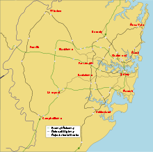 Major Sydney arterial routes
 Metroad 1 - Wahroonga to Waterfall via the M1 Eastern Distributor and the city of Sydney
 Metroad 2 - Artarmon to Windsor via the Lane Cove Tunnel and M2 Hills Motorway
 Metroad 3 - Blakehurst to Mona Vale via Hurstville, Olympic Park, Ryde, Macquarie Park and St. Ives
 Metroad 4 - Sydney to Lapstone via Parramatta Road and the M4 Western Motorway
 Metroad 5 - Sydney Airport to Campbelltown via the M5 South Western Motorway
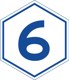
 Metroad 6 - Heathcote to Pennant Hills via Bankstown, Carlingford, Pennant Hills
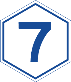
 Metroad 7 - Casula to Wahroonga via the Westlink M7 and Pennant Hills.
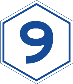
 Metroad 9 - Campbelltown to Windsor
 Metroad 10 - North Sydney to Mona Vale via Dee Why and Mosman.
Sections of Metroads 1, 2, 5, and 7 form the Sydney Orbital Network circumnavigating the Sydney metropolitan area.
Sydney Metroads Brisbane Metroads
The numbering system for Brisbane Metroads is straightforward, with odd numbers for north-to-south alignments and even numbers for east-to-west alignments. The "M" prefix is used exclusively for "M" routes under the alphanumeric system. "M1" has now replaced the Metroad 1 symbol on that corridor only.
 M1 - End of Pacific Motorway (Tugun) to Cooroy
 Metroad 2 - Cunningham Highway (National Highway 15) /Warrego Highway (National Highway A2) Junction to Gateway Motorway (Metroad 1)
 Metroad 3 - Pacific/Gateway Motorway Junction (Metroad 1) to Gympie Arterial Road/Gateway Motorway Junction (Metroad 1)
 Metroad 4 - Ipswich/Logan Motorway Junction (Metroad 2) to Pacific/Gateway Motorway Junction (Metroad 1)
 Metroad 5 - Ipswich Motorway (Metroad 2) to Gympie Road (Metroad 3)
 Metroad 6 - Logan/Gateway Motorway Junction (Metroad 4) to Pacific Motorway (Metroad 1)
- North South Bypass Tunnel / Airport Link Under Construction
Brisbane Motorways 


M1 M2 M3 M5 M7 Major Motorways Pacific · Bruce · Gateway · Ipswich · ICB · Logan · Western · Centenary · CLEM7 · Airport Link See also
External links
Categories:- Australian highways
- Brisbane Metroads


Wikimedia Foundation. 2010.