- Metroad 3
-
This article is about Metroad 3 in Sydney. For Metroad 3 in Brisbane, see Metroad 3, Brisbane.
Metroad 3
Route information Length: 52 km (32 mi) Existed: April 1993 – present Highway system Highways in Australia
National Highway • Freeways in Australia
Highways in New South Wales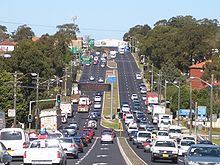 Metroad 3 as King Georges Rd looking south at Roselands
Metroad 3 is a Metroad in Sydney, New South Wales Australia. It replaced State Route 33 in April 1993[citation needed], from Metroad 10 in Mona Vale to Metroad 1 in Blakehurst. It has many names as it goes through different suburbs. Some of these are Mona Vale Road, Ryde Road, Lane Cove Road, Concord Road and Homebush Bay Drive. It is also known as Devlin Street, Church Street, Ryde, Centenary Drive, Roberts Road, Wiley Avenue and King Georges Road. It is also the only Metroad that has not changed alignment.
Metroad 3 is the inner western Sydney ring road. In its previous incarnations, it was Ring Road 3 from 1964 to 1974[citation needed] and State Route 33 from 1974 until 1993.[citation needed] It is the main thoroughfare for the inner western suburbs and the Northern Beaches and links them to all major arterials. It does not have any stretch of freeway and is very congested during peak hours, especially on the 2 lane sections of road.
It was upgraded to 3 lanes in each direction during the late 1970s & 1980s, between North St Ives, and the M5 Motorway at Beverly Hills. It remains, however, 2 lanes in each direction between Beverley Hills and South Hurstville at the southern end, and between St Ives and Terrey Hills to the north. From Terrey Hills to its northern termination at Mona Vale, it is mostly 1 lane in each direction. It is not known when the widening to 3 lanes between Beverley Hills and South Hurstville will be completed as the previous preparations for this, ie. Houses moved back from roadway and road reservations (empty blocks of land) were made but no continuance to the project was made.
It goes under the Pacific Highway (Metroad 1) at Pymble (grade separation completed in 1989), M2 Hills Motorway (Metroad 2) at Macquarie Park, M4 Western Motorway (Metroad 4) at Homebush and M5 South Western Motorway (Metroad 5) at Beverly Hills. It terminates at the Princes Highway junction at Blakehurst. King Georges Road is a major section of this route from Blakehurst to Wiley Park.
It is believed that this route will be known as the A3 when alphanumerical road numbering is introduced in New South Wales in the near future.
Metroad Suburbs
- Mona Vale
- St. Ives
- Pymble
- West Pymble
- Macquarie Park
- North Ryde
- Ryde
- Rhodes
- Liberty Grove
- Sydney Olympic Park (formerly Homebush Bay)
- Homebush West (Flemington)
- Wiley Park
- Beverly Hills
- Hurstville
- Blakehurst
Sydney Metroads Road infrastructure in Sydney Motorways / Tollways Freeways / Expressways Cahill Expressway • Gore Hill Freeway • Southern Cross Drive • Southern Freeway • M5 East • Sydney–Newcastle Freeway • Warringah Freeway • Western Distributor • General Holmes DriveMetroads Bridges and Tunnels Vehicle Ferries Conceptual Plans Sydney Orbital Network • Sydney Bypasses (past, present and proposed)Other M4 East (proposed) • Marrickville Tunnel (proposed) • North Western Expressway (abandoned) • F3 to Sydney Orbital (proposed) • F6 to Marrickville Tunnel (proposed)Categories Streets in Sydney • Highways in SydneyOperators Roads and Maritime Services • Connector Motorways • TransurbanTransport in Sydney Categories:- Sydney Metroads


Wikimedia Foundation. 2010.