- Mortlake Ferry
-
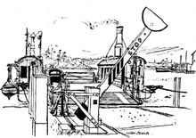
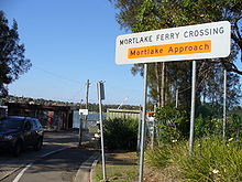
The Mortlake Ferry, also known as the Putney Punt, is a cable ferry that runs across the Parramatta River in Sydney, connecting Hilly Street in Mortlake and Pellisier Road in Putney.
Contents
History and heritage
The vehicular ferry between Mortlake and Putney was opened on the 16th May 1928. [1] [2] The service was established to serve the factory areas of Mortlake.[3]. The ferry opening pre-dated the nearby Ryde Bridge which opened in 1935, and it was one of several vehicular ferries operating across the Parramatta River at the time.
The Mortlake Ferry is one of ten remaining vehicular cable ferries in New South Wales, and the only one still in use on Sydney Harbour or its tributaries. While carrying much less traffic than it has in the past, the ferry still operates daily and is protected by a heritage order by the National Trust of Australia.[4]
Operation
The ferry is operated by a private sector operator under contract to New South Wales Roads and Maritime Services (RMS), carries a maximum of 15 cars plus passengers at a time, and is free of tolls. The crossing is some 300 metres (980 ft) in length and takes approximately 5 minutes. The ferry operates on demand on weekdays from 0645 to 0925 and 1445 to 1815; on weekends and public holidays it operates every half-hour from 1030 to 1730 from Mortlake and from 1045 from Putney. The 1245 weekend service runs ten minutes earlier from Putney, and 0100 five minutes later from Mortlake to provide a short lunchtime break. [5][4]
The ferry has magenta flashing lights on the ferry and at both end points when it is in operation. Sydney Ferries services must grant right of way to the Mortlake Ferry unless they have established radio contact and agreed on priority. [6]
Mortlake Slipway
A slipway located to the south of the Mortlake approach ramp is used for the maintenance of all the RMS-owned ferries operating in the Sydney region. Besides the Mortlake Ferry, this includes the Berowra Waters Ferry, Sackville Ferry, Webbs Creek Ferry and Wisemans Ferry, all of which operate on the Hawkesbury River and its tributaries.[5][4]
References
- ^ "New Punt Opened". The Sydney Morning Herald. 17 May 1928. http://nla.gov.au/nla.news-article16465256. Retrieved 07 September 2010.
- ^ NSW Roads and Traffic Authority. "Cable Ferry Crossing, Mortlake". http://www.rta.nsw.gov.au/cgi-bin/index.cgi?action=heritage.show&id=4301056. Retrieved 07 September 2010.
- ^ Andrews, Graeme (1994). Ferries of Sydney (third ed.). Oxford University Press with Sydney University Press. pp. 214–217. ISBN 0424002027.
- ^ a b c "Sackville Ferry". New South Wales Roads and Traffic Authority. http://www.rta.nsw.gov.au/cgi-bin/index.cgi?action=heritage.show&id=4305034. Retrieved 2008-11-18.
- ^ a b "Vehicle ferries". New South Wales Roads and Traffic Authority. http://www.rta.nsw.gov.au/usingroads/vehicleferries/. Retrieved 2008-11-18.
- ^ New South Wales Maritime. "Code of Conduct : Mortlake Ferries and State Transit Authority Passenger Ferries". http://www.maritime.nsw.gov.au/docs/cvdocs/CoCMortlakeFerry.pdf. Retrieved 09 September 2010.
External links
- RTA vehicle ferry operation information - includes timetable.
- Sydney Sketchbook - A trip on the Putney Punt in 1954
Road infrastructure in Sydney Motorways / Tollways Freeways / Expressways Cahill Expressway • Gore Hill Freeway • Southern Cross Drive • Southern Freeway • M5 East • Sydney–Newcastle Freeway • Warringah Freeway • Western Distributor • General Holmes DriveMetroads Bridges and Tunnels Vehicle Ferries Berowra Waters · Lower Portland · Mortlake · Sackville · Webbs Creek · WisemansConceptual Plans Other M4 East (proposed) • Marrickville Tunnel (proposed) • North Western Expressway (abandoned) • F3 to Sydney Orbital (proposed) • F6 to Marrickville Tunnel (proposed)Categories Streets in Sydney • Highways in SydneyOperators Transport in Sydney Major public transport services in Greater Sydney Commuter rail
(CityRail)Airport & East Hills Line · Bankstown Line · Carlingford Line · Cumberland Line · Eastern Suburbs & Illawarra Line · Inner West Line · North Shore Line · Northern Line · Olympic Park Line · South Line · Western Line
Under planning: North West Rail Link · Parramatta to Epping Rail Link
Under construction: South West Rail LinkRegional rail Blue Mountains Line · Hunter Line · Newcastle & Central Coast Line · South Coast Line · Southern Highlands LineCommuter bus
(Buses in Sydney)Regional bus Ferry Berowra Waters · Dangar Island · Eastern Suburbs · Inner Harbour · Lower Portland · Lane Cove River · Manly · Mortlake · Parramatta River · Pittwater (ex Church Point) · Pittwater (ex Palm Beach) · Port Hacking · Sackville · Taronga Zoo · Webbs Creek · WisemansOther Coordinates: 33°50′11″S 151°06′26″E / 33.83646°S 151.107314°E
Categories:- Ferries of Australia
- Ferry transport in Sydney
Wikimedia Foundation. 2010.


