- Northern railway line, Sydney
-
Northern Line 
Mode Commuter rail line Owner CityRail Operator(s) CityRail Connects Chatswood, North Sydney, Wynyard, Town Hall, Central, Strathfield, Epping, Hornsby Length 39 km Stations 30 Fleet K, H sets Depot(s) Hornsby Line colour Red Key dates 1886 Opened 1932 Extended through the CBD to North Sydney 2009 Epping to Chatswood Line Opened The Northern Line is part of the metropolitan rail network in Sydney known as CityRail. It serves the northern suburbs of Sydney and the Lower North Shore, along with parts of the Inner West and the Hills District. The line utilises the Epping to Chatswood Line and parts of the Main Northern Line, North Shore Line and Main Suburban Line. It is denoted as red on CityRail network maps and other publicity. Cityrail initially promised the Northern Line would be fully air-conditioned in the October 2009 timetable changes because the older non-air-conditioned trains were too noisy to run on the Epping-Chatswood rail link. However, Railcorp took remedial soundproofing works on the underground rail link in 2010 and this has meant that many services on the Northern Line are in fact non-air-conditioned, with the oldest non-air-conditioned CityRail L, R & S sets now allowed on the Epping-Chatswood rail link.
Contents
Line Description
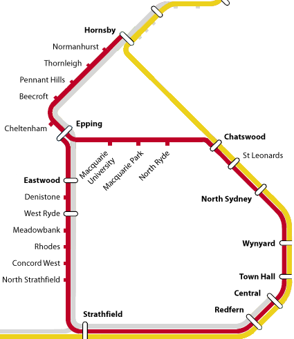
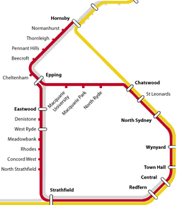 Diagram of the new Northern Line. The line is marked in red.
The line begins at Hornsby - a junction station with the North Shore Line. The line heads south to Epping using the Main Northern Line. At Epping the line heads underground to the Macquarie employment centre and Chatswood via the Epping to Chatswood Line. The line surfaces at Chatswood and joins the North Shore Line for the run south towards the City. Trains pass through North Sydney station before heading across the Harbour Bridge and through the underground stations of Wynyard and Town Hall, and the surface stations of Central and Redfern. Services then run along the Main Suburban Railway, usually using the middle 'Suburban' pair of the six tracks between Redfern and Strathfield. Services generally do not stop at intermediate stations between Redfern and Burwood. At Strathfield, trains usually head onto a flyover over the 'Main lines', before heading north back on the Main Northern Line, crossing the Parramatta River between Rhodes and Meadowbank, and terminating at Epping's surface platforms. At Epping trains reverse and complete the route in the opposite direction.
History
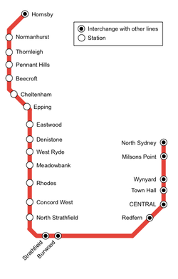 Diagram of the old Northern Line
The traditional Northern Line was the suburban portion of the Main Northern Line which opened in as a single track line 1886. In 1892, the line was duplicated to Hornsby,[1] and electrified in 1926 as part of the Bradfield electrification scheme. In 1932 the line was connected to the City underground. In 2009 the line was replaced by its current route. In the years prior to the 2009 revamp, Tangaras (T/G sets), R/S sets (includes 6 cars only) operated on the Strathfield-Hornsby section of the Northern Line.
Line Information
 The Northern Line crosses the Parramatta River at Meadowbank. Here, the old railway bridge has been converted to a cycleway.
The service frequency for the Northern Line between Hornsby and the City via the Epping to Chatswood Line:
- Monday to Friday AM Peak and Morning: 4 to 6 services per hour
- Monday to Friday Afternoon up to 3pm: 4 services per hour (2 services per hour will terminate at Chatswood)
- Monday to Friday PM Peak and Evening: 4 to 6 services per hour
- Saturday and Sunday: 4 services per hour (2 services per hour will terminate at Chatswood)
For the section of Northern Line between Epping and City via Strathfield, the following service frequency applies:
- Monday to Friday AM Peak and Morning: 4 services per hour
- Monday to Friday Afternoon up to 1.30 pm from Hornsby/Epping: 2 services per hour
- Monday to Friday PM Peak and Evening: 4 services per hour
- Saturday and Sunday: 2 services per hour
During peak hour some trains may follow the old route (i.e. Hornsby to North Sydney) via Strathfield and the City and vice-versa.[citation needed]
Stations
Name of Station Code Distance from
Central
Opened
MyMulti
ZoneServing Suburbs Pattern stops
at this stationConnections Northern Line Hornsby HBY 35.3 km 1886 Two Hornsby, Waitara 
■North Shore Line
■Newcastle & Central Coast LineNormanhurst NMH 33.1 km 1895 Two Normanhurst Thornleigh THL 30.8 km 1886 Two Thornleigh, Westleigh Pennant Hills PLL 30 km 1886 Two Pennant Hills, Cherrybrook Beecroft BCF 28.3 km 1886 Two Beecroft Cheltenham CHT 26.8 km 1898 Two Cheltenham Epping (Underground) EPG 24.8 km 1886 Two Epping, North Epping, Marsfield Lower ■Northern Line
■Newcastle & Central Coast LineMacquarie University MCU 20.9 km 2009 Two Macquarie University, Marsfield Macquarie Park MQP 19.6 km 2009 Two Macquarie Park North Ryde NRQ 18.2 km 2009 Two North Ryde Chatswood CWD 11.7 km 1890 One Chatswood ■North Shore Line Artarmon ATO 10.3 km 1898 One Artarmon, Willoughby ■North Shore Line St Leonards STL 8.4 km 1890 One St Leonards, Gore Hill, Narenburn ■North Shore Line Wollstonecraft (peak hours only) WSC 7.2 km 1893 One Wollstonecraft, Greenwich ■North Shore Line Waverton (peak hours only) WVT 6.1 km 1893 One Waverton ■North Shore Line North Sydney NSY 5.1 km 1932 One North Sydney ■North Shore Line Milsons Point MPT 4.4 km 1932 One Milsons Point, Kirribilli ■North Shore Line Wynyard WYN 2.1 km 1932 One Sydney CBD, The Rocks, Millers Point ■Bankstown Line ■South Line
■Airport & East Hills Line
■Inner West Line ■North Shore LineTown Hall THL 1.2 km 1932 One Sydney CBD, Darling Harbour ■Eastern Suburbs & Illawarra Line
■Bankstown Line ■South Line
■Airport & East Hills Line
■Inner West Line ■North Shore Line
■South Coast Line
(peak hours only)Central CEN 0 km 1855 One Central, Strawberry Hills, Ultimo, Surrey Hills ■Eastern Suburbs & Illawarra Line
■Bankstown Line
■Airport & East Hills Line
■South Line ■Inner West Line
■Western Line ■North Shore Line
■South Coast Line
■Blue Mountains Line
■Newcastle & Central Coast Line
■Southern Highlands Line
(peak hours only)Redfern RDF 1.3 km 1878 One Redfern, Waterloo, Darlington, The University of Sydney ■Eastern Suburbs & Illawarra Line
■Bankstown Line ■South Line
■Airport & East Hills Line*
■Western Line ■Inner West Line
■South Coast Line*
■Blue Mountains Line*
■Newcastle & Central Coast Line*
*peak hours only
Burwood BUW 10.6 km 1855 Two Burwood ■Western Line ■South Line ■Inner West Line Strathfield SFD 11.8 km 1876 Two Strathfield ■Western Line ■South Line ■Inner West Line
■Newcastle & Central Coast Line
■Blue Mountains LineNorth Strathfield NST 13.4 km 1918 Two North Strathfield, Concord West, Concord Concord West CCW 14.5 km 1887 Two Concord West, Liberty Grove, Concord, Homebush Bay/Olympic Park Rhodes RHS 16.6 km 1886 Two Rhodes, Rhodes Waterside, Liberty Grove Meadowbank MEB 18.2 km 1887 Two Meadowbank, Shepherd's Bay, Putney, Melrose Park West Ryde WSR 19.2 km 1886 Two West Ryde, Ryde Denistone DST 20.2 km 1937 Two Denistone Eastwood EAW 21.4 km 1886 Two Eastwood, Marsfield ■Newcastle & Central Coast Line Epping (Aboveground) EPG 23.4 km 1886 Two Epping, North Epping, Marsfield Upper ■Northern Line
■Northern Line to Chatswood
■Newcastle & Central Coast LineStopping Patterns
- Pattern 1: Hornsby, all stations to Epping, Macquarie University, Macquarie Park, North Ryde, Chatswood, all stations to Central, Redfern, Burwood, Strathfield, all stations to Epping. (peak hours only)
- Pattern 2: Hornsby, all stations to Epping, Macquarie University, Macquarie Park, North Ryde, Chatswood, Artarmon, St Leonards, North Sydney, all stations to Central, Redfern, Burwood, Strathfield, all stations to Epping. (off-peak hours and weekends)
- Pattern 3: Hornsby, all stations to Epping, Macquarie University, Macquarie Park, North Ryde, Chatswood. (off-peak hours and weekends)
References
- ^ "NSW Railway Passenger Services 1880-1905.". Australian Railway History, April 2005. ARHS NSW Division. http://www.arhsnsw.com.au.
- ^ a b "NSW Rail.net Main North line". http://www.nswrail.net/lines/show.php?name=NSW:main_north. Retrieved 2007-07-03.
- ^ a b "NSW Rail.net North Shore line". http://www.nswrail.net/lines/show.php?name=NSW:north_shore. Retrieved 2007-07-03.
- ^ a b "NSW Rail.net City Circle". http://www.nswrail.net/lines/show.php?name=NSW:city_circle. Retrieved 2007-07-03.
- ^ a b "NSW Rail.net Main South line". http://www.nswrail.net/lines/show.php?name=NSW:main_south. Retrieved 2007-07-03.
Further reading
- The Short North Singleton, C.C. Australian Railway Historical Society Bulletin, March to June, 1965
External links
- Neety's Train Page - information on suburban stations.
- New South Wales Railways - historical information on suburban stations.
- Cityrail - current timetable.
- Australian Railmaps - information & maps of train services & stopping patterns.
- Transport Infrastructure Development Corporation project website
Major public transport services in Greater Sydney Commuter rail
(CityRail)Airport & East Hills Line · Bankstown Line · Carlingford Line · Cumberland Line · Eastern Suburbs & Illawarra Line · Inner West Line · North Shore Line · Northern Line · Olympic Park Line · South Line · Western Line
Under planning: North West Rail Link · Parramatta to Epping Rail Link
Under construction: South West Rail LinkRegional rail Blue Mountains Line · Hunter Line · Newcastle & Central Coast Line · South Coast Line · Southern Highlands LineCommuter bus
(Buses in Sydney)Regional bus Ferry Berowra Waters · Dangar Island · Eastern Suburbs · Inner Harbour · Lower Portland · Lane Cove River · Manly · Mortlake · Parramatta River · Pittwater (ex Church Point) · Pittwater (ex Palm Beach) · Port Hacking · Sackville · Taronga Zoo · Webbs Creek · WisemansOther Categories:- Railway lines in Sydney
- Standard gauge railways in Australia


Wikimedia Foundation. 2010.