- Metrobus (Sydney)
-
Metrobus 

Mode Bus rapid transit Owner Ministry of Transport Operator(s) State Transit
Hillsbus
Veolia Transport NSWLength 13 bus rapid transit routes Key dates 12/10/08 Route 10 begins operation 26/10/09 Route 20 begins operation 28/3/10 Route 30 begins operation 18/7/10 Route 40 begins operation 08/8/10 Route 52 begins operation 10/10/10 Route 54 begins operation 31/10/10 Route 50 begins operation 6/12/10 Route 90 begins operation 19/12/10 Route 41 begins operation 20/12/10 Route 61 begins operation 7/02/11 Route 91 begins operation 7/03/11 Route 60 begins operation 14/03/11 Route 92 begins operation Metrobus is a high frequency, high capacity public transportation network in Sydney that links key employment and growth centres. Metrobuses run every 10 minutes during peak periods, 15 minutes during off-peak weekday periods, and 20 minutes on weekends, with the intention of making timetables obsolete. All articulated high-capacity metrobuses can carry up to 115 passengers[1] and are equipped with on-bus next stop displays and digital voice announcements, air conditioning and digital CCTV for enhanced security.[2]
Services are largely integrated with the public transport network of Sydney. Buses are painted in a distinctive red livery. All route numbers are prefixed with an "M", and follow the Sydney bus route numbering system, with the exception to the cross-CBD routes.
History
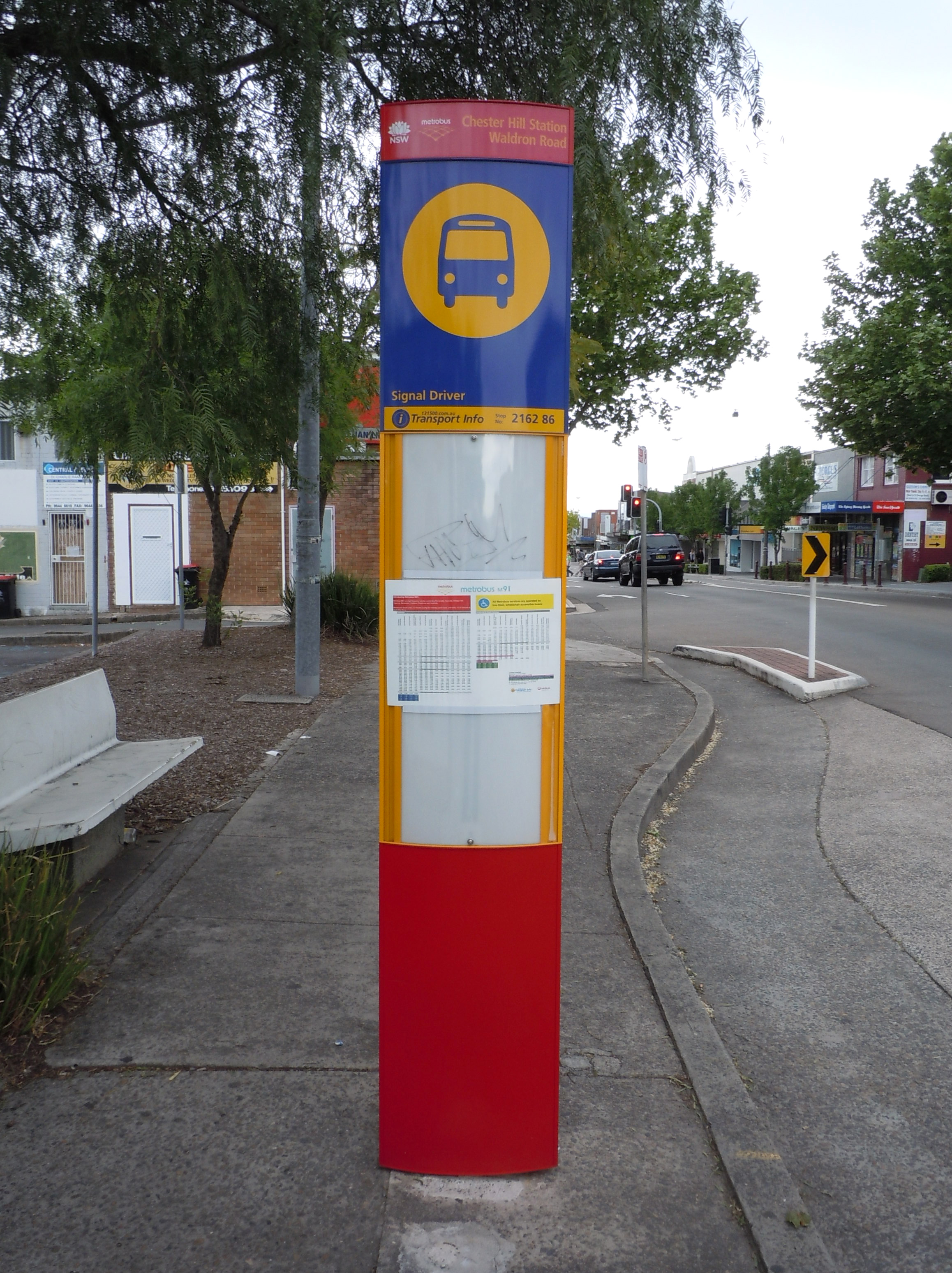
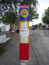 Metrobus blade stop sign at Chester Hill. This sign features the name of the stop and a red lower section indicating that the stop is served by metrobuses.
The network originally operated along bus trunk routes through the inner suburbs, but passed through the CBD rather than terminating there. This reduced overcrowding on the trunk routes without needing to layover extra buses in the CBD. This concept was later diluted with the network's expansion to include long distance routes servicing major activity centres in the greater western suburbs.
The first route, M10 began operation on a 12-month trial basis on October 12, 2008,[3] during this period 9 regular buses and 6 new high-capacity metrobuses with different seating arrangements serviced the route.[1]
In March 2009, the NSW government announced the expansion of the metrobus network with the addition of four further routes serving the inner suburbs (M20, M30, M40, M50).[4]
On July 20, 2010, Transport Minister John Robertson announced eight new Metrobus routes to be rolled out in 2011 to service suburbs in Sydney's west, north, north-west, south and south-west (M41, M52, M54, M60, M61, M90, M91, M92).[5]
Tickets and fares
Metrobus services are integrated with the MyZone system. All STA metrobus services use the Automated Fare Collection System to validate tickets. Metrobus routes M10, M20, M30, M40 and M50 are full-time pre-pay only services and require commuters to purchase a ticket before boarding the bus.
Routes
M10: Leichhardt to Maroubra Junction
Operated by State Transit Authority
M10 runs from Leichhardt to Maroubra Junction via Parramatta Road, Town Hall Station and Anzac Parade. The Route 10 metrobus service connects passengers to CityRail stations at Central, Town Hall and Museum stations and Metro Monorail stations at The Galeries Victoria. It also allows passengers to transfer to regular buses to outer suburbs of Sydney at major transport interchanges such as Broadway, Railway Square, Sydney Town Hall, Museum, Cleveland Street, and Kingsford.
On 28 December 2008, Metrobus Route 10 services was modified to terminate and start from Norton Street, Leichhardt Town Hall instead. The Route 10 services no longer operate between Leichhardt Town Hall and MarketPlace, Leichhardt nor stop at bus stops at Cromwell Street and Elswick Street due to issues raised by Leichhardt Council regarding bus parking in Lords Road at the MarketPlace terminus. On 14 November 2010, Metrobus Route 10 services were extended to the corner of Norton Street and William Street at Leichhardt Pioneer Park.
On 26 October 2009, Route 10 was extended from Kingsford to Maroubra Junction.
Route Diagram Name of station Stop number Locations served Connections M10 Leichhardt Town Hall 20W Leichhardt, Norton Street Palace Cinema Norton Plaza 19W Norton Street Plaza Norton Street 18W Norton Street Italian Forum Catherine Street 17W Sydney Institute of TAFE - Petersham College Percival Road 16W Annandale, Stanmore Johnston Street 15W Annandale Bridge Road 14W Annandale Denison Street
(Westbound only)13/14W Camperdown, Annandale Mallett Street 13W Camperdown Missenden Road 12W Royal Prince Alfred Hospital Larkin Street 11W University of Sydney Ross Street 10W University of Sydney Sydney Uni (Footbridge) 9W University of Sydney Sydney Uni (Main Gate)
(Westbound only)8/9W University of Sydney Victoria Park 8W University of Sydney, Victoria Park, Broadway Shopping Centre Broadway 7W Broadway, Broadway Shopping Centre Bus: Newtown, Glebe Point Road Abercrombie Street 6W Broadway, Ultimo University of Technology (UTS) 5W UTS, Broadway, Ultimo, Haymarket Railway Square 4W Railway Square, Sydney Institute of TAFE, Ultimo, Haymarket Train: Central Station
Bus: Northern BeachesRawson Place 3W Chinatown, Paddy's Markets, Haymarket Chinatown
(Westbound only)2/3W Chinatown, Paddy's Markets, Haymarket Light Rail: Capitol Square Station World Square 2W Chinatown, World Square, Town Hall Sydney Town Hall 1W Town Hall, Queen Victoria Building, St. Andrew's Cathedral, George St Cinemas Train: Town Hall Station Park Street City 1E Town Hall, The Galeries Victoria, Pitt Street Mall Monorail: Galeries Victoria Hyde Park 2E Hyde Park Museum 3E Hyde Park, Downing Centre Train: Museum Station
Bus: Bondi Beach, Paddington, Bondi Junction, BronteBrisbane Street 4E Whitlam Square Riley Street 5E Oxford Square Taylor Square 6E Taylor Square, St Vincent's Hospital, University of Notre Dame Australia Albion Street 7E Surry Hills, UNSW College of Fine Arts South Dowling Street
(Eastbound only)7/8E Surry Hills Moore Park 8E Moore Park, Sydney Cricket Ground, Sydney Football Stadium Cleveland Street 9E Moore Park, Fox Studios, Entertainment Quarter Bus: Randwick, Coogee Robertson Street 10E Moore Park, Centennial Park Alison Road
(Eastbound only)10/11E Moore Park Supa Centa Carlton Street 11E Randwick Racecourse Ascot Street 12E Randwick Racecourse Todman Ave 13E Kensington Addison Street 14E Kensington Doncaster Avenue 15E Kensington UNSW 16E University of New South Wales Barker Street 17E University of New South Wales Middle Street 18E Kingsford Kingsford 19E Kingsford Bus: Maroubra, La Perouse, Rockdale, Burwood Wallace Street
(Eastbound only)20E Kingsford Sturt Street 21E Kingsford Botany Street 22E Kingsford Paton Street 23E Kingsford Broadbent Street 24E Kingsford Avoca Street 25E Kingsford Snape Street 26E Maroubra Junction Storey Street 27E Maroubra Junction Bowen Street 28E Maroubra Junction Maroubra Junction 29E Maroubra Junction M20: Gore Hill to Botany
Operated by State Transit Authority
M20 runs from Gore Hill to Botany via Pacific Highway, Town Hall Station and Botany Road. The service began on 26 October 2009.[6] The M20 metrobus service connects passengers to CityRail stations at Central, Town Hall, Wynyard, North Sydney and St Leonards stations. It also allows passengers to transfer to regular buses to outer suburbs of Sydney at major transport interchanges such as Railway Square, Sydney Town Hall, Wynyard, North Sydney and St Leonards. On 27 February 2011, M20 was extended from Mascot to Botany shops.[7]
Route Diagram Name of station Stop number Locations served Connections M20 Reserve Road 22N Bunnings Warehouse, Home HQ Homemaker Centre Campbell Street 21N Technology Park
(Southbound only)20N North Sydney College TAFE 19N North Sydney College TAFE Greenwich Road 18N Portview Road - Gore Hill Oval 17N St Leonards - Royal North Shore Hospital 16N Royal North Shore Hospital, The Forum Shopping Centre Train: St Leonards Station Albany Street 15N Hume Street 14N Crows Nest Shopping Village Crows Nest
(Northbound only)13N Crows Nest Shopping Village Crows Nest - Falcon Street 12N Crows Nest Shopping Village Mater Hospital 11N Mater Hospital West Street 10N Bay Road
(Northbound only)9N Berry Street
(Northbound only)8N Victoria Cross 7N North Sydney 6N North Sydney, Greenwood Plaza Train: North Sydney Station Lang Park
(Southbound only)5N Lang Park, The Rocks Train: Circular Quay Station Wynyard 4N Martin Place, Theatre Royal Train: Wynyard Station King Street
(Northbound only)3N King Street Wharf QVB
(Southbound only)2N Queen Victoria Building, Cockle Bay, Darling Harbour Park Street - Town Hall 1 Sydney Town Hall, Queen Victoria Building, Pitt Street Mall, Galleries Victoria, Sydney Tower, State Theatre, Cockle Bay, Darling Harbour Train: Town Hall Station
Monorail: Galeries VictoriaBathurst Street 2S Hyde Park, Anzac War Memorial Goulburn Street - Downing Centre 3S Downing Centre Wentworth Avenue
(Southbound only)4S Hay Street 5S Capitol Theatre, Sydney Chinatown Central 6S Railway Square Train: Central Station Devonshire Street 7S Belvoir Street 8S Prince Alfred Park, Belvoir Street Theatre Cleveland Street 9S Redfern Street 10S Redfern Park 11S Redfern Oval, South Sydney Leagues Club Young Street 12S Baptist Street
(Southbound only)13S Danks Street 14S Lachlan Street
(Northbound only)15S McEvoy Street
(Northbound only)16S Powell Street 17S O'Dea Avenue 18S Victoria Park 19S Victoria Park, Green Square Victoria Park - Gadigal Avenue
(Southbound only)20S Victoria Park, Green Square Hansard Street 21S Dunning Avenue 22S Collins Street 23S Queen Street 24S Green Central Business Park Hayes Road 25S Harcourt Parade 26S Harcourt Business Park Gardeners Road 27S Tramway Street
(Northbound only)28S Rolfe Street 29S Coward Street 30S Mascot PS - Tunbridge Street 31S Mascot 32S Mascot Bus: Bondi Junction, Rockdale, Burwood M30: Mosman to Sydenham
Operated by State Transit Authority
M30 runs from Mosman to Sydenham via Military Road, Town Hall Station and King Street, and began on 28 March 2010.[8] The Route 30 metrobus service connects passengers to CityRail stations at Wynyard, Town Hall, Central, Newtown and Sydenham stations. It also allows passengers to transfer to regular buses to outer suburbs of Sydney at major transport interchanges such as Railway Square, Sydney Town Hall, Wynyard, Neutral Bay Junction, and Spit Junction.
Route Diagram Name of station Stop number Locations served Connections M30 Spit Junction 19N Bus: Northern Beaches, Mosman, Taronga Zoo Bond Street 18N Lang Street 17N Belmont Road 16N Cremorne Junction 15N Hampden Avenue 14N Neutral Bay Junction 13N Bus: North Sydney, Chatswood, Northern Beaches Watson Street - Big Bear 12N Lang Park
(Southbound only)5N Lang Park, The Rocks Train: Circular Quay Station Wynyard 4N Martin Place, Theatre Royal Train: Wynyard Station Queen Victoria Building 2N Queen Victoria Building, Cockle Bay, Darling Harbour Sydney Town Hall 2W Town Hall, Queen Victoria Building, St. Andrew's Cathedral, George St Cinemas Train: Town Hall Station
Bus: Victoria RoadWorld Square 3W Chinatown, World Square, Town Hall Chinatown
(Southbound only)4W Chinatown, Paddy's Markets, Haymarket Light Rail: Capitol Square Station Rawson Place 5W Chinatown, Paddy's Markets, Haymarket Railway Square 6W Railway Square, Sydney Institute of TAFE, Ultimo, Haymarket Train: Central Station
Bus: Eastern, Inner WestUniversity of Technology (UTS) 7W UTS, Broadway, Ultimo, Haymarket Abercrombie Street 8W Broadway, Ultimo Broadway 9W Broadway, Broadway Shopping Centre Bus: Newtown, Glebe Point Road Victoria Park - City Road
(Southbound only)10W University of Sydney, Victoria Park, Broadway Shopping Centre Seymour Centre 11W University of Sydney, Seymour Centre University of Sydney - City Road 12W University of Sydney Carillon Avenue 13W Queen Street 14W Missenden Road - Newtown 15W Church Street
(Northbound only)16W Erskineville Road 17W Newtown Station 18W Train: Newtown Station
Bus: Rockdale, TempeNewtown RSL 19W Enmore Theatre 20W Enmore Post Office 21W Newington Road 22W Enmore Park 23W Edinburgh Road 24W Chapel Street 25W Sydenham Road 26W Marrickville Road 27W Barclay Street 28W Sydenham Station 29W Train: Sydenham Station M40: Chatswood to Bondi Junction
Operated by State Transit Authority
M40 runs from Chatswood to Bondi Junction via Willoughby Road, Wynyard Station, Town Hall Station and Oxford Street, and began on 18 July 2010. The Route 40 metrobus service connects passengers to CityRail stations at Chatswood, Wynyard, Town Hall, Museum and Bondi Junction stations. It also allows passengers to transfer to regular buses to outer suburbs of Sydney at major transport interchanges such as Chatswood, Sydney Town Hall, Wynyard, and Bondi Junction.
Route Diagram Name of station Stop number Locations served Connections M40 Chatswood Interchange 29N Chatswood Plaza, Lemongrove Shopping Centre, Chatswood Transport Interchange Train: Chatswood Station
Bus: Northern Beaches, Mosman, Taronga ZooChatswood Civic Place - Westfield 28N Chatswood Westfield, St Pius College, Our Lady of Dolours Primary School Chatswood Chase 27N Chatswood Chase, Mercy College Baldry Street
(Southbound only)26N Macquarie Street 25N Victoria Avenue - Penshurst Street 24N North Willoughby Shops 23N North Willoughby Shopping Village Crabbes Avenue 22N Club Willoughby (Willoughby RSL Club) Forsyth Street 21N St Thomas Primary School Rosewall Street 20N Laurel Street 19N Willoughby Girls High School 18N Willoughby Girls High School, Willoughby Public School Hudson Avenue 17N Willoughby Shops 16N Willoughby Shops Small Street 15N Willoughby Pool, Channel Nine News Studios Garland Road 14N Lang Park
(Southbound only)5N Lang Park, The Rocks, Circular Quay Train: Circular Quay Station Wynyard 4N Martin Place, Theatre Royal Train: Wynyard Station King Street
(Northbound only)3N King Street Wharf QVB
(Southbound only)2N Queen Victoria Building, Cockle Bay, Darling Harbour Park Street 1 Town Hall, Queen Victoria Building, St. Andrew's Cathedral, George St Cinemas, The Galeries Victoria, Pitt Street Mall, Sydney Tower, State Theatre Train: Town Hall Station
Bus: Park Street Interchange
Monorail: Galeries VictoriaHyde Park 2E Hyde Park, Anzac War Memorial Museum 3E Hyde Park, Downing Centre Train: Museum Station
Bus: Bondi Beach, Paddington, Bondi Junction, BronteBrisbane Street 4E Whitlam Square, Oxford Square Riley Street 5E Oxford Square Taylor Square 6E Taylor Square, St Vincent's Hospital, University of Notre Dame Australia St Vincents Hospital
(Westbound only7E St Vincents Hospital Verona Street 8E UNSW College of Fine Arts Glenmore Road 9E Victoria Barracks Brodie Street 10E Victoria Barracks Paddington Town Hall 11E Oxford Street William Street 12E Oxford Street Paddington Public School 13E Paddington Town Hall, Paddington Public School Queen Street 14E Paddington Markets Victoria Avenue - Woollahra
(Eastbound only)15E Paddington Markets Moncur Street
(Westbound only)16E Centennial Park Centennial Park - Loch Avenue
(Westbound only)17E Centennial Park Waverley Bus Depot 18E Newland Street 20E Bondi Junction Interchange 21E Westfield Bondi Junction, Oxford Mall, Eastgate Shopping Centre Train: Bondi Junction Station M41: Hurstville to Macquarie Park Station
Operated by State Transit Authority
M41 runs from Hurstville to Marsfield via Bexley North, Clemton Park, Campsie, Burwood and Top Ryde, and began on 19 December 2010.[9] The Route 41 metrobus service connects passengers to CityRail stations at Hurstville, Bexley North, Campsie, Burwood, Rhodes, Macquarie Park and Macquarie University stations. It also allows passengers to transfer to regular buses to outer suburbs of Sydney at major transport interchanges such as Macquarie Centre, Top Ryde City and Hurstville.
M50: Drummoyne to Coogee
Operated by State Transit Authority
M50 runs from Drummoyne to Coogee via Anzac Bridge, CBD and Fox Studios and Alison Road, and began on 31 October 2010.[10] The Route 50 metrobus service connects passengers to CityRail stations at Wynyard, Town Hall, and Museum stations. It also allows passengers to transfer to regular buses to the Moore Park Area.
M52: Parramatta to Circular Quay
Operated by State Transit Authority
M52 runs from Parramatta to Circular Quay via Victoria Road, Top Ryde, Wynyard Station, and Town Hall Station, and began on 8 August 2010. The Route 52 metrobus service connects passengers to CityRail stations at Parramatta, West Ryde, Town Hall, Wynyard and Circular Quay stations. It also allows passengers to transfer to regular buses to outer suburbs of Sydney at major transport interchanges such as Parramatta, Top Ryde, Sydney Town Hall, Wynyard, and Circular Quay. It has replaced the old L20 route and is supplemented by the current 520 route outside of the Metrobus operating hours. [11]
Route Diagram Name of station Stop number Locations served Connections M52 Parramatta Interchange ? CityRail trains, local bus services, Westfield Parramatta, historical sites, cafés and restaurants. Train: Parramatta Station George Street, Parramatta ? Phillip Street, Parramatta ? All Saints, Parramatta ? Betts Street
(Westbound only)? Thompson Reserve ? Wandsworth Street ? Shorts Corner ? UWS Parramatta ? UWS Parramatta Campus Bridge Street, Rydalmere ? Train: Rydalmere Station Euston Street ? Parkland Estate ? Myrtle Street ? Park Road
(Eastbound only)? Rydalmere Primary School ? Alma Street ? Kirby Street ? Ermington Shops ? Wentworth Street ? Turner Street ? Atkins Road ? Hughes Avenue ? Bartlett Park ? Marsden Road ? Brush Road ? Darvall Road ? Shaftsbury Road ? Bellevue Avenue ? Mons Avenue ? West Ryde Shops ? West Ryde shopping centre Train: West Ryde Station Hermitage Road
(Westbound only)? Forsyth Street ? Bowden Street ? Sewell Street
(Eastbound only)? Parkes Street
(Eastbound only)? Hinkler Avenue
(Eastbound only)? Shepherd Street
(Westbound only)? Samuel Street
(Eastbound only)? Belmore Street
(Westbound only)? Top Ryde ? Top Ryde City Shopping Centre Ryde Park ? Beazley Street ? Monash Road ? Gladesville Shops ? Henley ? Lyons Road, Drummoyne ? Birkinhead Point ? Birkinhead Point Shopping centre. Terry Street ? Rozelle Junction ? White Bay ? Druitt Street, CBD ? QVB, George Street
(Eastbound only)? Town Hall, Queen Victoria Building, St. Andrew's Cathedral, George St Cinemas Cockle Bay, Darling Harbour, Pyrmont Train: Town Hall Station George & King Streets ? Wynyard/George Street ? Martin Place, Theatre Royal Train: Wynyard Station Essex Street
(Westbound only)? Bridge Street
(Westbound only)? Circular Quay ? Ferry Services, The Rocks Train: Circular Quay Station M54: Parramatta to Macquarie Park
Operated by State Transit Authority
M54 runs from Parramatta to Macquarie Park via Carlingford and Epping, and began on 10 October 2010. The Route 54 metrobus service connects passengers to CityRail stations at Parramatta, Carlingford, Epping, Macquarie University, and Macquarie Park stations. It also allows passengers to transfer to regular buses to outer suburbs of Sydney at major transport interchanges such as Parramatta, Epping, and Macquarie Centre. It replaced the old 548 route.
Route Diagram Name of station Stop number Locations served Connections M54 Parramatta Interchange ? CityRail trains, local bus services, Westfield Parramatta, historical sites, cafés and restaurants. Train: Parramatta Station Church & George Streets, Parramatta
(Eastbound only)? George Street, Parramatta
(Westbound only)? Lennox Bridge ? Victoria Road ? Grose Street ? Fennell Street
(Westbound only)? Belmore Park ? Bellevue Street, North Parramatta ? Sutherland Rd South ? Sutherland Rd North ? Burnside Shopping Centre ? Gollan Avenue ? Vista Street ? King’s School ? Sydney Baptist College ? Westminster Avenue ? Cumberland High School ? Baker Street ? Martins Lane
(Westbound only)? Charles Street ? Carlingford Station ? Carlingford Town Train: Carlingford Station Evans Road ? Hepburn Avenue ? Mars Street ? Pennant Parade
(Eastbound only)? Orchard Street ? Hermington Street ? Park Street, Epping ? Ryde Street ? Midson Road ? Kent Street ? Rawson Street
(Westbound only)? Epping Station ? Epping CBD Train: Epping Station Smith Street ? Crandon Road
(Westbound only)? Pembroke Street ? Lucknow Park ? Vimiera Road ? Coral Street
(Westbound only)? Culloden Road ? Balaclava Road
(Westbound only)? Shalom Nursing Home ? Macquarie University
(Eastbound only)? University Avenue
(Westbound only)? Macquarie Drive
(Eastbound only)? Herring Road
(Eastbound only)? Macquarie Centre ? Macquarie Shopping Centre Train: Macquarie University Station Cottonwood Crescent
(Eastbound only)? Byfield Street ? Khartoum Road ? Coolinga Street ? Macquarie Park Station ? Macquarie Park CBD, Foxtel Building, Canon Building Train: Macquarie Park Station Lane Cove Road ? Hyundai Building M60: Parramatta to Hornsby
Operated by Hillsbus
M60 runs from Parramatta to Hornsby via Baulkham Hills, Castle Hill, Cherrybrook, Pennant Hills, Thornleigh and Normanhurst, and began on 7 March 2011.[12] It connects with Parramatta, Pennant Hills and Hornsby CityRail stations and other bus services at major interchanges Parramatta, Castle Hill and Hornsby. It replaced the 600 service between Parramatta and Castle Hill, and complements the 632 service between Pennant Hills and Hornsby.
M61: Castle Hill to Railway Square
Operated by Hillsbus
M61 runs from Castle Hill to Railway Square via Baulkham Hills and the M2 Busway and complements the existing 610X service. It began on 20 December 2010.[13] The service allows passengers to connect with services to Kellyville, Glenwood, Kellyville Ridge, Bella Vista and Stanhope Gardens at bus stops along the M2 Motorway, as well as the Castle Hill Interchange.
Route Diagram Name of station Stop number Locations served Connections M61 Castle Hill Interchange 2154190 Castle Hill, Castle Towers Buses: Hills District Cecil Avenue 2154116 Castle Hill Benaara Gardens (Northbound Only)
? Church Street 2154117 St Gabriel's 2154118 St Gabriel's School for Hearing Impaired Children Excelsior Avenue 2154119 Gilroy College Oxley Avenue ? Baulkham Hills Pool Baulkham Hills TAFE ? Baulkham Hills TAFE Chelsea Avenue near TAFE (Northbound Only)
? Cross Street ? Baulkham Hills Ackling Street ? Hill Street ? Stockland Mall ? Stockland Mall Bus: Carlingford, Epping, North Rocks Baulkham Hills Bowls Club ? Baulkham Hills Bowls Club Baulkham Hills Junction (Southbound Only)
? Baulkham Hills Bus: Parramatta Charles Street ? Cook Street (Southbound Only)
? Torrs Street ? Barclay Road M2 Bus Station 2151152 North Rocks Bus: Lane Cove, Macquarie Park, Milsons Point, North Sydney, Seven Hills, Blacktown Oakes Road M2 Bus Station 212511 West Pennant Hills Wynyard 200036 Martin Place, Theatre Royal Train: Wynyard Station Clarence Street (Northbound Only)
? Queen Victoria Building 2000136 Queen Victoria Building, Cockle Bay, Darling Harbour Train: Town Hall Station Bus: Victoria Road
Sydney Town Hall ? Town Hall, Queen Victoria Building, St Andrew's Cathedral, George Street cinemas Train: Town Hall Station Bus: Victoria Road
Goulburn Street ? Chinatown Railway Square 2000188 Haymarket, Sydney Institute of TAFE, Ultimo, USYD, UTS Train: Central Station Bus: Eastern, Inner West
M90: Burwood to Liverpool
 Metrobus M90 at Bankstown Station
Operated by Veolia Transport NSW
M90 runs from Burwood to Liverpool via Strathfield, Chullora, Greenacre, Bankstown, Milperra and Moorebank, and began on 6 December 2010.[14] The M90 service replaced the 900 service and connects passengers to CityRail stations at Strathfield, Burwood, Bankstown, and Liverpool stations. It also allows passengers to transfer to other buses in Burwood, Strathfield, Bankstown and Liverpool. M90 also connects to the M91 and M92 services at Bankstown and with the Liverpool-Parramatta T-way.
M91: Parramatta to Hurstville
Operated by Veolia Transport NSW
M91 runs from Parramatta to Hurstville via Granville, South Granville, Chester Hill, Yagoona, Bankstown, Padstow, Peakhurst and Penshurst, and began on 7 February 2011.[15] The M91 service replaces the 910 and 948 services and connects passengers to CityRail stations at Parramatta, Granville, Chester Hill, Yagoona, Bankstown, Padstow, and Hurstville stations. M91 connects with the M52, M54, M60 and M92 services at Parramatta, the M90 and M92 services at Bankstown and the M41 service at Hurstville as well as connecting with local bus services.
M92: Parramatta to Sutherland
 A Metrobus M92 at Bankstown Station
Operated by Veolia Transport NSW
M92 runs from Parramatta to Sutherland via Lidcombe, Bankstown, Padstow and Menai, and began 14 March 2011, it marked the last Metrobus route launched to date.[15]
Fleet
The Metrobus bus fleet consists of buses sourced from various manufacturers with differing seating arrangements. All Metrobuses have low floor entry, are wheelchair accessible, fully air conditioned and contain digital CCTV surveillance. The fleet is environmentally friendly being to Euro 3 standard or better.
State Transit Authority
STA Metrobuses are operated from either Burwood, Leichhardt, Tempe, Ryde or Port Botany depots. The fleet consists of:
High capacity buses
 Volvo B12BLEA Euro V / Custom Coaches CB60 EvoII.
- 2 x Volvo B12BLEA Articulated buses / Custom Coaches CB60 (Fleet# 1668 & 1701)
- 2 x Volvo B12BLEA Euro V Articulated buses / Custom Coaches CB60 EvoII (Fleet# 2109 & 2110)
- 1 x Scania K310UA Articulated bus / Custom Coaches CB60 Evo II 'Combo' (Fleet# 2111)
- 1 x Scania N310UA Articulated bus / Volgren CR228L (Fleet# 2112)
- 95 x Volvo B12BLEA Euro V Articulated buses / Volgren CR228L
Standard buses
- 30 x Mercedes-Benz OC500LE CNG buses / Custom Coaches CB60 EvoII
- 17 x Volvo B12BLE Euro V / Custom Coaches CB60 EvoII (Burwood only)
- 10 x Volvo B12BLE / Custom Coaches CB60 EvoII (Burwood only)
Hillsbus
- 22x Volvo B7RLE 12.5 metre bus/ Volgren CR228L
- 10x Scania K280UB 14.5 metre bus/ Volgren CR228L
Veolia Transport NSW
- 30x Volvo B7RLE / Volgren CR228L
- 10x Volvo B7RLE / Bustech VST
- 20x Mercedes Benz O500LE / Bustech VST
- ??x Volvo B7RLE / Custom Coaches CB60 EvoII
See also
- Sydney Buses
- Hillsbus
- Veolia Transport NSW
References
- ^ a b Robins, Robin (2007-08-16). "All aboard: super-size buses will leave others standing". Sydney Morning Herald. http://www.smh.com.au/news/national/all-aboard-supersize-buses-will-leave-others-standing/2007/08/15/1186857596845.html. Retrieved 2008-10-11.
- ^ Metrobus Brochure
- ^ Sydney Buses: metrobus - starts Sunday 12 October
- ^ Major Expansion of metrobus across Sydney, 131500.info. Retrieved 26 March 2009.
- ^ Nicholls, Sean (2010-07-20) "New Metrobus Routes For Sydney". Sydney Morning Herald. Retrieved 2010-07-20.
- ^ [1], 131500.info. Retrieved 23 October 2009.
- ^ Sydney Buses: Metrobus M20 extended to Botany Shops from 27 February 2011
- ^ [2], Sydney Buses - Metrobus 30. Retrieved 27 March 2010.
- ^ http://www.sydneybuses.info/news/m41-2013-hurstville-to-macquarie-park-starts-sunday-19-december
- ^ [3], 131500 Prepay Service information. Retrieved 8 October 2010.
- ^ "Metrobus M52 - Parramatta to City - starts Sunday 8 August". Sydney Buses. July 28, 2010. http://www.sydneybuses.info/news/371/234.htm. Retrieved 2 September 2010.[dead link]
- ^ http://www.cdcbus.com.au/Metrobus-M60.html
- ^ http://www.cdcbus.com.au/Metrobus-M61.html
- ^ [4], Veolia Transport NSW - Metrobus Routes. Retrieved 24 November 2010.
- ^ a b [5], Veolia Transport NSW - Metrobus Routes. Retrieved 7 March 2010.
External links
- Transport Info Metrobus home page
- NSW Department of Transport Metrobus home page
- Sydney Buses Metrobus home page
- Hillsbus - Metrobus M60
- Hillsbus - Metrobus M61
- Veolia Transport - Metrobus M90, M91 and M92
Major public transport services in Greater Sydney Commuter rail
(CityRail)Airport & East Hills Line · Bankstown Line · Carlingford Line · Cumberland Line · Eastern Suburbs & Illawarra Line · Inner West Line · North Shore Line · Northern Line · Olympic Park Line · South Line · Western Line
Under planning: North West Rail Link · Parramatta to Epping Rail Link
Under construction: South West Rail LinkRegional rail Blue Mountains Line · Hunter Line · Newcastle & Central Coast Line · South Coast Line · Southern Highlands LineCommuter bus
(Buses in Sydney)Regional bus Ferry Berowra Waters · Dangar Island · Eastern Suburbs · Inner Harbour · Lower Portland · Lane Cove River · Manly · Mortlake · Parramatta River · Pittwater (ex Church Point) · Pittwater (ex Palm Beach) · Port Hacking · Sackville · Taronga Zoo · Webbs Creek · WisemansOther Categories:- Bus transport in New South Wales

Wikimedia Foundation. 2010.