- Hornsby, New South Wales
Infobox Australian Place
type = suburb
name = Hornsby
state = nsw
city = Sydney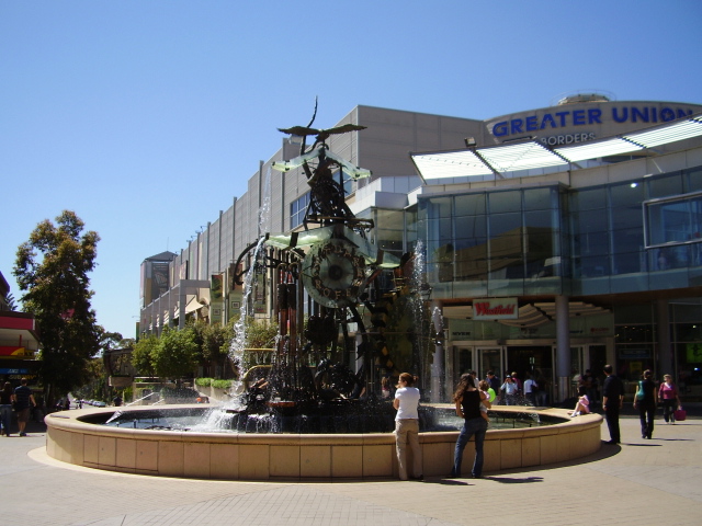
caption = Florence Street Mall with fountain and Westfield Shoppingtown
pop = 18,702 [Census 2006 AUS|id=SSC11483|name=Hornsby (State Suburb) |accessdate=2007-09-08 |quick=on ]
postcode=2077
lga = Hornsby Shire
stategov= Hornsby, Ku-ring-gai
fedgov= Berowra, Bradfield
near-nw = Hornsby Heights
near-n = Asquith
near-ne = North Wahroonga
near-w = Dural
near-e = Wahroonga
near-sw = Thornleigh
near-s = Normanhurst
near-se = Waitara
dist1 = 25
dir1 = north-west
location1= SydneyHornsby is a suburb on the Upper North Shore of
Sydney , in the state ofNew South Wales ,Australia . Hornsby is located 25 kilometres north-west of theSydney central business district and is the administrative centre of the local government area ofHornsby Shire .History
The name Hornsby is derived from
Convict -turned-Constable Samuel Henry Horne, who took part in the apprehension ofbushranger s Dalton and MacNamara onJune 22 ,1830 . In return he was granted land which he named Hornsby Place.European Settlement
The first white settler in the area of what is now the suburb of Hornsby was Thomas Higgins, who received a grant of land in Old Mans Valley.
A railway station named "Hornsby Junction" opened on the 17th of September, 1886 to the north of the town of Hornsby, which had developed on the site of Horne's grant. It formed the junction of the Northern Line and the North Shore Line which were still be completed at that time. [cite web|title=Hornsby Shire Council History|url=http://www.hornsby.nsw.gov.au/library/index.cfm?NavigationID=653] . "Hornsby" station was one stop further south on the Northern Line. Due to confusion by commuters alighting at the incorrect station expecting to transfer to a connecting train, the old Hornsby station was renamed Normanhurst on the 17th of November, 1898 [cite web|title=Rail Page|url=http://www.railpage.org.au/ausrail/00feb/msg01776.html] after prominent local activist and engineer Norman Selfe, while the Hornsby Junction station assumed the current name of Hornsby.
The Hornsby Shire Council was established in 1906. In 1961,
The Westfield Group built ashopping mall at Hornsby, making it one of the first suburbs in Sydney with a modern-style shopping centre. A competing shopping centre, "Northgate", opened in 1979 but was eventually bought by Westfield. In late 1999, the two sites were amalgamated when the original Westfield was demolished and Northgate was renovated to create the newWestfield Hornsby which opened in November 2001.Transport
Hornsby is 26 km by train from the Sydney
central business district and is approximately 24.5 km by road. Hornsby railway station [ [http://www.waitara-waldorf-apartments.com.au/photos/images/dscf0064_jpg.jpgphoto] ] is a junction of the Northern Line and the North Shore line of theCity Rail network. There are frequent railway services to thecentral business district via Strathfield on the Northern Line or via North Sydney on the North Shore Line. Hornsby is also a transport junction of Northern Sydney with Intercity and Express trains stopping here on the way to the Central Coast, Newcastle and further north.Bus services operate from Hornsby, most by Shorelink, to local areas such as Normanhurst.
The Pacific Highway, which passes through Hornsby, was formerly the main road link between Sydney and north-eastern Australia. The completion of the F3
Sydney-Newcastle Freeway , which has its southern end at the neighbouring suburb of Wahroonga, means that the heavy traffic now bypasses the already busy Hornsby town area [ [http://www.rta.nsw.gov.au/trafficreports/cameras/f3.html F3 Freeway] ] .Commercial Areas
Hornsby remains a busy commercial centre, just as it was a century ago. Over the years, the town centre has developed distinct characteristics on either side of the railway line.
The western side consists of a traditional
high street shopping village along the Old Pacific Highway. A short section of the highway north of the shops still has several antique lamp posts preserved. On the eastern side of the highway from south to north are the police station, the court house [ [http://www.cjc.nsw.gov.au/lc.nsf/files/hornsby_courthouse.jpg/$FILE/hornsby_courthouse.jpg court house] ] and the historic Hornsby Shire Council chamber (built in two stages in 1915 and 1930). On the western side is Hornsby Park with a swimming pool and bushland beyond itGregory's Street Directory, 59th Edition 1995, Map 191 F16] . A largewar memorial and the adjacent RSL Club is located at the southern end of the shops.The eastern side is dominated by
Westfield Hornsby , a shopping centre, which features two department stores, a cinema multiplex, a food court and several restaurants. The intersection of Florence Street and Hunter Street became a pedestrian mall in the early 1990s. At the centre of the pedestrian mall is a large water clock sculpture, designed by Victor Cusack. The public library is also located in this area.The north-western side of the suburb is occupied by various industries and the northern end of Hornsby features a major
Cityrail railway workshop.Residential Areas
Residential areas, consisting of low-to-medium density housing, are located on both sides of the railway line. Many of residential areas on the western side of the train line enjoy bushy surrounds and close proximity to Regional and National Parks, as well as the beautiful Lisgar Gardens.
In recent years, high-rise apartments have been constructed adjacent to the train line as part of the NSW state planning policies to allow medium to high density development along transport corridors.
chools
Hornsby is home to a number of schools, including the secondary schools
Barker College andHornsby Girls' High School . There is also aTAFE College at the north-western side of Hornsby. The Hornsby Ku-ring-gai Hospital on Hornsby's eastern side is the main public hospital for the Upper North Shore.Hornsby is the home to [http://www.ramsayhealth.com.au/mwp/| Mt Wilga Private Hospital] , which is a rehabilitation hospital. It is on the western side of the railway line.Landmarks
"The Fountain", Hornsby Odeon, Hornsby RSL, Hornsby inn, The Quarry, Fagan Park, Hornsby War Memorial
Culture
Hornsby has long been associated with "
Ginger Meggs " [ [http://www.hinet.net.au/~meggs Ginger Meggs] ] , a cartoon byJimmy Bancks who grew up in Hornsby, which has appeared in Australian newspapers since 1921.The local newspaper that serves the area is the Hornsby Advocate, owned by the Cumberland Newspaper Group.
References
ee also
*
Rosamond Street External links
Wikimedia Foundation. 2010.