- Normanhurst, New South Wales
-
Normanhurst
Sydney, New South WalesPopulation: 4,786[1] Postcode: 2076 Area: 2.15 km² (0.8 sq mi) Location: 23 km (14 mi) north-west of Sydney CBD LGA: Hornsby Shire State District: Hornsby
Ku-Ring-GaiFederal Division: Berowra, Bradfield Suburbs around Normanhurst: Hornsby Hornsby Waitara Thornleigh Normanhurst Wahroonga Thornleigh Pennant Hills Wahroonga Normanhurst is a suburb of Sydney, in the state of New South Wales, Australia. Normanhurst is located 23 kilometres north-west of the Sydney central business district in the local government area of Hornsby Shire.
Contents
History
Normanhurst was originally known as Hornsby, with the suburb that is now known as Hornsby called Jack's Island.[2] The construction of the Northern railway line and North Shore railway line in the 1890s brought about a name change. The two railway lines were joined at a station called Hornsby Junction, whereas the station one stop south on the Northern line kept the name Hornsby. Due to confusion around the similarly named stops, the postmaster demanded that Hornsby station change its name.[3]
Normanhurst was derived from the name of a prominent resident, civil engineer Norman Selfe (1839–1911),[4] with hurst being the English word for a wooded hill. Ironically, Selfe protested against the name change. The railway station was renamed in 1900 and was used for the suburb that developed around it.
Geography
Normanhust is split down the middle by Pennant Hills Road, a major north-south thoroughfare that leads into the F3 Freeway on the north, and going down south into Parramatta. However, both the east and west parts have extensive bush access. On the east side, a small section of bush lies between Normanhurst and Fox Valley. This is land owned by the SAN hospital, but not yet been developed. On the western side, the suburb backs onto the southern reaches of the Berowra Valley, a continuous section of bush stretching all the way to Broken Bay. This gives Normanhurst a very "leafy" look, in comparison to its neighbours Hornsby, Pennant Hills and Thornleigh. This in turn contributes to making native bird life abundant. The area is home to cockatoos, rainbow lorikeets, kookaburras, noisy miners and native brush turkeys. It also has encouraged the growth of retirement residences in the suburb.
Commercial area
Normanhurst has a small number of shops close to Normanhurst railway station but is very close to the large commercial centre at Hornsby.
Transport
Normanhurst is well serviced by rail and buses and since it lies around Pennant Hills Road, car access is also easy. Normanhurst railway station is on the Northern railway line of the CityRail network. The railway station originally known as 'Hornsby', opened on the 21st of November, 1895 [5] and the name was changed to Normanhurst in 1900.
Schools
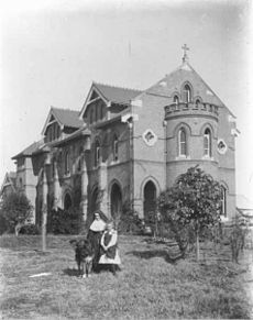 Loreto, 1897
- Clark Road School (Private)
- Hornsby South Public School (Public)
- Loreto Normanhurst (Private, girls only) [6]
- Normanhurst Boys' High School (Public, selective, boys only) [7]
- Normanhurst Public School (Public)[8]
- Normanhurst West Public School (Public) [9]
Churches
- St. Stephen's Anglican Church [10]
- Queen of Peace Catholic Church [11]
- Normanhurst Uniting Church [12]
- The Church of Jesus Christ of Latter-day Saints
Sport and recreation
- Normanhurst Sports Club [13]
- Normanhurst is home to the Normanhurst Eagles Football Club, their home ground is Normanhurst Oval. The club caters for both male and female second-rate football players in junior and senior divisions. The club's flagship team currently play in the Gladesville Hornsby Football Association's second-tier Super League competition.
Politics
Normanhurst is part of the Hornsby Council Local Government Area. Following the most recent redistribution of electoral districts for the New South Wales Legislative Assembly, parts of the suburb of Normanhurst fall within three different electoral divisions, namely Hornsby, Ku-ring-gai and Epping. See New South Wales Legislative Assembly Electoral Districts
References
- ^ Australian Bureau of Statistics (25 October 2007). "Normanhurst (State Suburb)". 2006 Census QuickStats. http://www.censusdata.abs.gov.au/ABSNavigation/prenav/LocationSearch?collection=Census&period=2006&areacode=SSC11717&producttype=QuickStats&breadcrumb=PL&action=401. Retrieved 2007-09-08.
- ^ "OZpedia". http://ozpedia.org/Normanhurst,%20New%20South%20Wales.
- ^ The Book of Sydney Suburbs, Compiled by Frances Pollon, Angus & Robertson Publishers, 1990, Published in Australia ISBN 0-207-14495-8
- ^ A biography of Norman Selfe
- ^ "Hornsby Shire History". http://www.hornsby.nsw.gov.au/library/index.cfm?NavigationID=653.
- ^ Loreto Normanhurst school
- ^ Normanhurst Boys High School
- ^ Normanhurst Public School
- ^ Normanhurst West Public School
- ^ St. Stephen's Anglican Church Normanhurst
- ^ Queen of Peace Normanhurst
- ^ Normanhurst Uniting Church
- ^ Normanhurst Sports Club
- Area "Normanhurst". Hornsby Shire. http://www.id.com.au/hornsby/commprofile/default.asp?id=240&gid=250&pg=1. Retrieved 2007-09-08.
Coordinates: 33°43′31″S 151°06′03″E / 33.72521°S 151.10080°E
Suburbs within Hornsby Shire | North Shore | Hills District | Sydney Arcadia · Asquith · Beecroft · Berowra · Berowra Heights · Berowra Waters · Berrilee · Brooklyn · Canoelands · Carlingford · Castle Hill · Cheltenham · Cherrybrook · Cowan · Dural · Epping · Fiddletown · Forest Glen · Galston · Glenhaven · Glenorie · Hornsby · Hornsby Heights · Kangaroo Point · Laughtondale · Maroota · Middle Dural · Milsons Passage · Mount Colah · Mount Ku-ring-gai · Normanhurst · North Epping · Pennant Hills · Round Corner · Thornleigh · Wahroonga · Waitara · Westleigh · West Pennant Hills · Wisemans Ferry
Categories:- Suburbs of Sydney

Wikimedia Foundation. 2010.