- North Shore railway line
-
North Shore Line 
Mode Commuter rail line Owner CityRail Operator(s) CityRail Connects Central
Town Hall
North Sydney
Chatswood
Hornsby
BerowraStations 35 Fleet R, S, K, H, T, G sets Depot(s) Hornsby Line colour Yellow Key dates 1890 Opened  A North Shore Line train crossing the Sydney Harbour Bridge.
The North Shore Line is a part of the metropolitan rail network in Sydney, Australia, operated by CityRail. The North Shore Line extends from Sydney Central station through the western limb of the City Circle, across the Sydney Harbour Bridge and along the North Shore area to Hornsby where it joins the Northern Line.
Contents
History
The North Shore Line was opened on 1 January 1890 as a single track between Hornsby and St Leonards. The line was extended to the Sydney Harbour foreshore at Milsons Point on 1 May 1893. Transport between this original Milsons Point station and central Sydney was by ferry boat. Most of the North Shore line was duplicated between 1900 and 1909. In 1927 the line was converted to electric operation using a 1500 volt DC, overhead supply.
The construction works for the Sydney Harbour Bridge necessitated truncation of the southern terminus from Milsons Point to Lavender Bay.
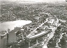 Aerial view of construction of the northern approach to the Sydney Harbour Bridge. The original railway alignment and construction work on the realignment for extension across the bridge can both be seen.
When the Sydney Harbour Bridge was opened in 19 March 1932 a new Milsons Point station (on the bridge approach) came into operation and the North Shore Line was extended through it and over the Sydney Harbour Bridge to link with the underground lines of central Sydney. The result is that the two ends of the North Shore Line link to the Sydney railway system at Central and Hornsby.
After 1932 the original Lavender Bay station became a storage depot for electric trains, and the line connecting Lavender Bay to the North Shore line was reduced to single track. This line joins the current passenger-carrying North Shore line at Waverton station.
The North Shore Line is now a major commuter artery between the North Shore and central Sydney. In early years, Old Milsons Point, Bay Road, St Leonards, Chatswood, Lindfield, Gordon, Pymble, Turramurra, Wahroonga and Hornsby stations had goods yards. All but St Leonards, Chatswood and Hornsby yards had disappeared by mid-twentieth century, and the latter three did not survive into the late twentieth century.
The NSW Government Urban Transport Statement identifies capacity and service improvements for the North Shore Line with plans to add extra tracks between Gordon and Chatswood, and extra platforms at St Leonards by 2017.[1]
North Shore Line stations
Name of Station Code Distance from
Central[2][3][4]Opened
MyMulti
ZoneServing Suburbs Pattern stops at this station Connections through service originates from ■Western Line North Shore Line Central CEN 0 km 1855 One Central,
Strawberry Hills,
Ultimo,
Surry Hills
■Eastern Suburbs & Illawarra Line
■Bankstown Line
■Airport & East Hills Line
■South Line ■Inner West Line
■Western Line ■Northern Line
■South Coast Line
■Blue Mountains Line
■Newcastle & Central Coast Line
■Southern Highlands Line
(peak hours only)Town Hall TWH 1.2 km 1932 One Sydney CBD,
Darling Harbour■Eastern Suburbs & Illawarra Line
■Bankstown Line ■South Line
■Airport & East Hills Line
■Inner West Line ■Northern Line
■South Coast Line
(peak hours only)Wynyard WYN 2.1 km 1932 One Sydney CBD, The Rocks,
Millers Point■Bankstown Line ■South Line
■Airport & East Hills Line
■Inner West Line ■Northern LineMilsons Point MPT 4.4 km 1932 One Milsons Point,
Kirribilli■Northern Line North Sydney NSY 5.1 km 1932 One North Sydney,
Crows Nest■Northern Line Waverton WVT 6.1 km 1893 One Waverton,
Lavender Bay,
North Sydney
■Northern Line Wollstonecraft WSC 7.2 km 1893 One Wollstonecraft,
Greenwich■Northern Line St Leonards STL 8.4 km 1890 One St Leonards,
Gore Hill,
Osbourne Park,
Greenwich■Northern Line Artarmon ATO 10.3 km 1898 One Artarmon,
Willoughby,
Narenburn■Northern Line Chatswood CWD 11.7 km 1890 One Chatswood ■Northern Line Roseville RSV 13.3 km 1890 Two Roseville Lindfield LFD 14.6 km 1890 Two Lindfield,
West Lindfield,
East LindfieldKillara KIL 15.9 km 1899 Two Killara,
East LindfieldGordon GDN 17.1 km 1890 Two Gordon,
West PymblePymble PYM 18.9 km 1890 Two Pymble,
West PymbleTurramurra TRM 20.8 km 1890 Two Turramurra Warrawee WAE 21.9 km 1900 Two Warrawee,
WahroongaWahroonga WRO 22.6 km 1890 Two Wahroonga Waitara WAI 24.2 km 1895 Two Waitara Hornsby HBY 33.9 km 1886 Two Hornsby,
Waitara■Northern Line
■Newcastle & Central Coast LineAsquith ASQ 35.7 km 1915 Three Asquith Mount Colah MCL 37.7 km 1887 Three Mount Colah Mount Kuring-gai MKI 40.7 km 1901 Three Mount Kuring-gai Berowra BER 44.7 km 1887 Three Berowra ■Newcastle & Central Coast Line Woy Woy
(peak hours only)WOY 72.6 km 1889 Three Woy Woy ■Newcastle & Central Coast Line Gosford
(peak hours only)GOS 80.9 km 1887 Three Gosford ■Newcastle & Central Coast Line Narara
(peak hours only)NRR 84.6 km 1887 Three Narara Niagara Park
(peak hours only)NIA 86.2 km 1902 Three Niagara Park Lisarow
(peak hours only)LRW 87.7 km 1887 Three Lisarow Ourimbah
(peak hours only)OUR 90.6 km 1908 Three Ourimbah Tuggerah
(peak hours only)TUG 98.5 km 1890 Three Tuggerah,
Mardi,
Chittaway Point,
Kangy AngyWyong
(peak hours only)WYG 101.1 km 1887 Three Wyong,
Wattanobi■Newcastle & Central Coast Line Stopping Patterns
- Pattern 1: all stations to Berowra (& vice-versa)
- Pattern 2: all stations to Hornsby (& vice-versa) *
- Pattern 3: all stations to Gordon (& vice-versa) (peak hours only).*
- Pattern 4: all stations to Gordon, then Hornsby only (peak hours only)
- Pattern 5: intercity limited stops services from Wyong - Tuggerah, Ourimbah, Narara, Gosford, Woy Woy, Berowra, Asquith, Hornsby, Turramurra, (Pymble), Gordon, Chatswood and all to Central (morning peak hours only).
- Pattern 6: intercity limited stops services to Gosford or Wyong - all to Chatswood, Gordon, Pymble, Turramurra, Hornsby, Asquith, Berowra, Woy Woy, Gosford, (all to Wyong) (peak hours only).
- Pattern 7: intercity limited stops services to Wyong - all to Gordon, Hornsby, Woy Woy, Gosford, all to Wyong (evening peak hours only).
* stations marked with
mean that a few trains on this pattern in peak hours may skip this station.The current off-peak service pattern is as follows: (includes continuations onto Western Line)
-
- 2tph Berowra all stations to Redfern, Strathfield, Lidcombe, Auburn, Clyde, Granville, Parramatta, Westmead, Seven Hills, Blacktown and then all stations to Penrith.
- 2tph Hornsby all stations to Redfern, Burwood, Strathfield, Lidcombe, Granville, Harris Park, Parramatta and then all stations to Richmond
References
- ^ http://www.metrostrategy.nsw.gov.au/dev/digitalAssets/2074_1184045743740_Transport.pdf
- ^ a b "NSW Rail.net North Shore line". http://www.nswrail.net/lines/show.php?name=NSW:north_shore. Retrieved 2007-07-03.
- ^ a b "NSW Rail.net Main North line". http://www.nswrail.net/lines/show.php?name=NSW:main_north. Retrieved 2007-07-03.
- ^ a b "NSW Rail.net City Circle". http://www.nswrail.net/lines/show.php?name=NSW:city_circle. Retrieved 2007-07-03.
Major public transport services in Greater Sydney Commuter rail
(CityRail)Airport & East Hills Line · Bankstown Line · Carlingford Line · Cumberland Line · Eastern Suburbs & Illawarra Line · Inner West Line · North Shore Line · Northern Line · Olympic Park Line · South Line · Western Line
Under planning: North West Rail Link · Parramatta to Epping Rail Link
Under construction: South West Rail LinkRegional rail Blue Mountains Line · Hunter Line · Newcastle & Central Coast Line · South Coast Line · Southern Highlands LineCommuter bus
(Buses in Sydney)Regional bus Ferry Berowra Waters · Dangar Island · Eastern Suburbs · Inner Harbour · Lower Portland · Lane Cove River · Manly · Mortlake · Parramatta River · Pittwater (ex Church Point) · Pittwater (ex Palm Beach) · Port Hacking · Sackville · Taronga Zoo · Webbs Creek · WisemansOther Categories:- Railway lines in Sydney
- Standard gauge railways in Australia


Wikimedia Foundation. 2010.