- Murrabit, Victoria
-
Murrabit
Victoria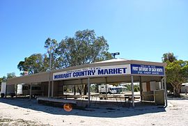
Site of the Murrabit Country Markets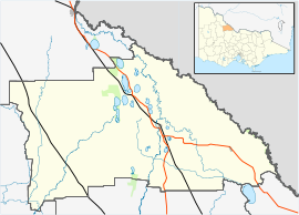
 Murrabit
Population: 408[1] Postcode: 3579 Coordinates: 35°31′S 143°57′E / 35.517°S 143.95°ECoordinates: 35°31′S 143°57′E / 35.517°S 143.95°E Location: LGA: Shire of Gannawarra State District: Swan Hill Federal Division: Mallee Murrabit is a town in north east Victoria, Australia. The town is located on the Murray River, 305 kilometres (190 mi) from the state capital, Melbourne and 52 kilometres (32 mi) from Swan Hill. Murrabit is in the Shire of Gannawarra Local government area and at the 2006 census, Murrabit and the surrounding area had a population of 408.[1]
The township was established in 1925 as a railway station on the Kerang-Stony Crossing Border Railway and is the site of an historic bridge. The lift span bridge was constructed in 1926 and used for rail and road until 1960 when the railway was closed. A Murrabit Post Office opened on 2 March 1880. This was renamed Murrabit West in 1924 when a new Murrabit office opened near the railway station. [2]
Murrabit is a major citrus producing area, with many orchards and packing sheds. Dairy is the other major industry with water provided through the Torrumbarry Irrigation System and milk being sold to processing plants at Leitchville and Rochester.
Murrabit is known for its regular country market. The market, held the first Saturday of each month, was established in 1977 and is reputed to be the biggest in regional Victoria.[3]
Golfers play at the course of the Murrabit Golf Club on Murrabit Road.[4]
References
- ^ a b Australian Bureau of Statistics (25 October 2007). "Murrabit (State Suburb)". 2006 Census QuickStats. http://www.censusdata.abs.gov.au/ABSNavigation/prenav/LocationSearch?collection=Census&period=2006&areacode=SSC26251&producttype=QuickStats&breadcrumb=PL&action=401. Retrieved 2007-08-05.
- ^ Premier Postal History, Post Office List, https://www.premierpostal.com/cgi-bin/wsProd.sh/Viewpocdwrapper.p?SortBy=VIC&country=, retrieved 2008-04-11
- ^ Visit Victoria - Tourist site - Retrieved 1 November 2006
- ^ Golf Select, Murrabit, http://www.golfselect.com.au/armchair/courseView.aspx?course_id=1043, retrieved 2009-05-11
External links
- Gannawarra Shire Council - Official site
- Murrabit.com - Community site
Towns in the Shire of Gannawarra Benjeroop • Cohuna • Kangaroo Lake • Kerang • Koondrook • Lake Charm • Lalbert • Leitchville • Macorna • Murrabit • Mystic Park • Quambatook • Tittybong • Tragowel •
Categories:- Towns in Victoria (Australia)
- Populated places on the Murray River
- Victoria (Australia) geography stubs


Wikimedia Foundation. 2010.