- Gore Highway
-
Gore Highway 

Formerly 
Length 202 km (126 mi) Direction West-East From 

 Leichhardt Highway, 19km north of Goondiwindi, Queensland
via Millmerran, Pittsworth To  Warrego Highway, Toowoomba, Queensland
Allocation National Highway A39 Gore Highway is a highway in Queensland running from Goondiwindi to Toowoomba. Together with Goulburn Valley Highway and Newell Highway, it is a part of the National Highway's Melbourne-Brisbane link. It is signed as
 .
.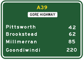 Approximate road distances (in kilometres) of towns from Toowoomba along the highway
It passes through the Queensland's Darling Downs region. Typical scenery are cattle grazing fields, orchards and grain growing fields. Its elevation to National Highway was only in February 1993 replacing Cunningham Highway for the Goondiwindi - Brisbane section, rerouting interstate traffic through Toowoomba and the Warrego Highway instead as it presents a less steeper gradient compared to the old routing, (via Warwick and Cunninghams Gap) making the journey, especially for trucks, faster. It was initially designated State Route 85 until February 1993 when National Highway 85 was proclaimed, splitting State Route 85 into two. In 2005 it was given the National Highway A39 designation.
Speed Zones
- Drayton (Toowoomba) - Westbrook 90 km/h
- Westbrook - Millmerran (25 km South West) 100 km/h
- Millmerran - Goondiwindi 110 km/h
Towns
See also
 Road infrastructure in Queensland
Motorways 
National Highways Barkly Highway • Bruce Highway • Cunningham Highway • Gore Highway • Landsborough Highway • Leichhardt Highway • New England Highway • Warrego HighwayHighways Balonne Highway • Barwon Highway • Brisbane Valley Highway • Burnett Highway • Bunya Highway • Capricorn Highway • Captain Cook Highway • Carnarvon Highway • Castlereagh Highway • Centenary Highway • D'Aguilar Highway • Dawson Highway • Donohue Highway • Flinders Highway • Gold Coast Highway • Gregory Highway • Isis Highway • Kennedy Highway • Leichhardt Highway • Mary Valley Highway • Mitchell Highway • Moonie Highway • Mount Lindesay Highway • Mulligan Highway • Outback Highway • Palmerston Highway • Peak Downs Highway • Wide Bay HighwayDevelopmental Roads /
Outback TracksBirdsville Track • Burke Developmental Road • Gregory Developmental Road • Gulf Developmental Road • Kennedy Developmental Road • Savannah WayProposals Categories:- Highways in Queensland


Wikimedia Foundation. 2010.