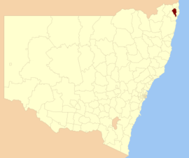
- City of Lismore
-
Lismore City
New South Wales
Location in NSWPopulation: 45,645(2009)[1] Area: 1290 km² (498.1 sq mi) [2] Mayor: Jenny Dowell Council Seat: Goonellabah (43 Oliver Avenue) Region: Northern Rivers State District: Lismore Federal Division: Page LGAs around Lismore City: Kyogle Tweed Byron Richmond Valley Lismore City Ballina Richmond Valley Richmond Valley Ballina The City of Lismore is a local government area in New South Wales, Australia. Its primary city, Lismore is a major regional centre in the Northern Rivers region of the state.
Contents
Demographics
In the 2006 Census of Population and Housing there were 42,210 usual residents living in Lismore City Council. Of this count, 20,543 (or 48%) were males and 21,667 (or 51%) were females.
By age, 20% of the population was under 15 years old, 66% were between 15 and 65, and 14% were over 65 years old.
Most people living in Lismore City Council were born in Australia (86%). The median age was 38 years.
Economy
According to the 2006 Census of Population and Housing, the median invididual income was $378 per week (equal to approximately $19,710 per year). The median family income in 2006 was $993 per week (equal to approximately $51,778 per year); and, the median household income in 2006 was $779 per week (equal to approximately $39,629 per year).
There were 17,834 people employed in 2006 (to give an employment to working age population ratio of 0.64), and 1,812 people unemployed. The most common occupations were Professionals (19%); Technicians and Trades Workers (14%); and, Clerical and Administrative Workers (13%). The top 5 industries for employment were Hospitals (6.2%); School Education (5.8%); Cafes, Restaurants and Takeaway Food Services (4.2%); Tertiary Education (3.3%); and, Supermarket and Grocery Stores (3.0%).
Housing
In the 2006 Census of Population and Housing, the median housing loan repayment was $1,083 per month. This equated to marginally under 35% of median household income.
The median rent in 2006 was $165 per week. This equated to just over 21% of median household income.
The average household size was 2.5 persons.
There is a large population of commission housing situated in the town of lismore.
Towns and localities
- Chilcotts Grass
- East Lismore
- Girards Hill
- Goonellabah
- Howards Grass
- Lismore
- Lismore Heights
- Loftville
- North Lismore
- South Lismore
- Woodburn
- Bentley
- Bexhill
- Blakebrook
- Blue Knob
- Booerie Creek
- Broadwater
- Buckendoon
- Caniaba
- Clunes
- Coffee Camp
- Corndale
- Dorroughby
- Dungarubba
- Dunoon
- East Coraki
- Eltham
- Georgica
- Goolmangar
- Gundurimba
- Jiggi
- Keerrong
- Koonorigan
- Larnook
- Leycester
- Lillian Rock
- Lindendale
- McKees Hill
- Modanville
- Monaltrie
- Numulgi
- Pearces Creek
- Richmond Hill
- Rock Valley
- Rosebank
- Ruthven
- South Gundurimba
- Terania Creek
- The Channon
- Tregeagle
- Tucki Tucki
- Tuckurimba
- Tullera
- Tuncester
- Tuntable Creek
- Whian Whian
- Woodburn
- Wyrallah
- Yeagerton
Sister cities
Lismore has sister city relations with the following cities[3]:
 Yamatotakada, Japan, since 1963
 Lismore, Ireland, since 2000
 Eau Claire, Wisconsin, USA, since 2001
 Makassar, Indonesia
References
- ^ Australian Bureau of Statistics (30 March 2010). "Regional Population Growth, Australia, 2008–09". http://www.abs.gov.au/ausstats/abs@.nsf/Latestproducts/3218.0Main%20Features42008-09?opendocument&tabname=Summary&prodno=3218.0&issue=2008-09&num=&view=. Retrieved 3 June 2010.
- ^ "Lismore City Council". Department of Local Government. http://www.dlg.nsw.gov.au/dlg/dlghome/dlg_CouncilContactDetails.asp?slacode=4850. Retrieved 2006-11-19.
- ^ Sister Cities
Coordinates: 28°49′S 153°17′E / 28.817°S 153.283°E
Local Government Areas of New South Wales Metropolitan Sydney Inner SydneyAshfield · Botany Bay · Burwood · Canada Bay · Canterbury · Hurstville · Kogarah · Lane Cove · Leichhardt · Manly · Marrickville · Mosman · North Sydney · Randwick · Rockdale · Strathfield · Sydney · Waverley · Willoughby · WoollahraOuter SydneyAuburn · Bankstown · Blacktown · Camden · Campbelltown · Fairfield · The Hills · Holroyd · Hornsby · Hunter's Hill · Ku-ring-gai · Liverpool · Parramatta · Penrith · Pittwater · Ryde · Sutherland · WarringahSydney SurroundsMid North Coast Bellingen · Clarence Valley · Coffs Harbour · Greater Taree · Kempsey · Nambucca · Port Macquarie-Hastings · Lord Howe IslandMurray Murrumbidgee Carrathool · Coolamon · Cootamundra · Griffith · Gundagai · Hay · Junee · Leeton · Lockhart · Murrumbidgee · Narrandera · Temora · Wagga WaggaHunter Cessnock · Dungog · Gloucester · Great Lakes · Lake Macquarie · Maitland · Muswellbrook · Newcastle · Port Stephens · Singleton · Upper HunterIllawarra Richmond Tweed Southeastern Bega · Bombala · Boorowa · Cooma-Monaro · Eurobodalla · Goulburn Mulwaree · Harden · Palerang · Queanbeyan · Snowy River · Tumut · Upper Lachlan · Yass Valley · YoungNorthern Armadale Dumaresq · Glen Innes-Severn · Gunnedah · Guyra · Gwydir · Inverell · Liverpool Plains · Moree Plains · Narrabri · Tamworth · Tenterfield · Uralla · WalchaCentral West North Western Far West Categories:- Local Government Areas of New South Wales
- North Coast, New South Wales
Wikimedia Foundation. 2010.
