- Clunes, New South Wales
-
Clunes
New South Wales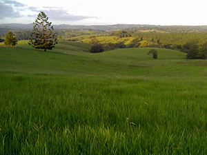
Looking north on James Gibson Road, Clunes, mid afternoon
 Clunes
Population: 520 (2006 census)[1] Coordinates: 28°44′0″S 153°24′0″E / 28.733333°S 153.4°ECoordinates: 28°44′0″S 153°24′0″E / 28.733333°S 153.4°E Time zone: • Summer (DST)
AEST (UTC+10) AEDT (UTC+11)
Location: LGA: City of Lismore, Byron Shire Region: Northern Rivers State District: Electoral district of Lismore Federal Division: Division of Richmond Clunes is a small village in the Northern Rivers region of New South Wales, Australia. It is located approximately 18 km northeast of Lismore.[2] In 2006, Clunes had a population of 520 people.[1]
Situated in hilly country, the volcanic soils provided by nearby Mount Warning allow for macadamia and coffee growing.
Also nicknamed "The Holy City" because of the number of fine early Australian churches in the village. Clunes has good local services including a general store, petrol station, and an antiques shop. With lots of attractive North Coast federation houses in the district, the area is popular with people working in nearby Lismore. The village is named after Robert Mortimer Clunes, an early engineer in the dairying industry.
Notes
- ^ a b Australian Bureau of Statistics (25 October 2007). "Clunes (L) (Urban Centre/Locality)". 2006 Census QuickStats. http://www.censusdata.abs.gov.au/ABSNavigation/prenav/LocationSearch?collection=Census&period=2006&areacode=UCL119050&producttype=QuickStats&breadcrumb=PL&action=401. Retrieved 28 June 2009.
- ^ Google Maps
Categories:- Towns in New South Wales
- North Coast, New South Wales
- New South Wales geography stubs


Wikimedia Foundation. 2010.