- City of Maitland
-
Maitland City
New South Wales
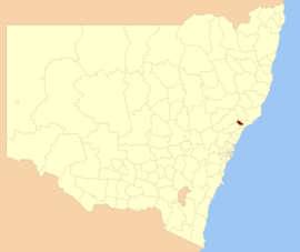
Location in New South WalesPopulation: 69,154(2009)[1] Coordinates: 32°45′S 151°35′E / 32.75°S 151.583°ECoordinates: 32°45′S 151°35′E / 32.75°S 151.583°E Area: 392 km² (151.4 sq mi) [2] Mayor: Peter Blackmore Council Seat: Maitland (285-287 High Street) Region: Hunter Valley State District: Maitland Federal Division: Hunter LGAs around Maitland City: Singleton Dungog Dungog Singleton Maitland City Port Stephens Cessnock Lake Macquarie Newcastle The City of Maitland is a Local Government Area in the Lower Hunter Region of New South Wales, Australia. It is on the New England Highway and CityRail's Hunter line.
Contents
Demographics
In 2001, there were 1,217 (2.3%) indigenous persons and 47,738 (88.9%) Australian-born persons in the city.[3]
Incomes
According to the Australian Bureau Statistics [4] during 2003-04, there:
- were 28,082 wage and salary earners (ranked 34thh in New South Wales and 100th in Australia, 0.9% of New South Wales's 2,558,415 and 0.3% of Australia's 7,831,856)
- was a total income of $936,144,529 (around $936 million) (ranked 39th in New South Wales and 103rd in Australia, 0.9% of New South Wales's $107,179,688,262 (around $107 billion) and 0.3% of Australia's $304,034,755,876 (around $304 billion))
- was an estimated average income per wage and salary earner of $38,873 (ranked 43rd in New South Wales and 123rd in Australia, 94% of New South Wales's $41,407 and 100% of Australia's $38,820)
- was an estimated median income per wage and salary earner of $34,886 (ranked 47th in New South Wales and 130th in Australia, 98% of New South Wales's $35,479 and 102% of Australia's $34,149).
Council
Maitland City Council is composed of twelve councillors elected proportionally. The area is divided into four wards, each electing three councillors. The mayor is directly elected.[5] The current makeup of the council, including the mayor, is as follows:[5]
Party Councillors Independents 5 Australian Labor Party 4 Liberal Party of Australia 4 Total 13 The current council, elected in 2008, is:[5]
Ward Councillor Party Notes Mayor Peter Blackmore Independent Central Ward Arch Humphery Independent Elected on Peter Blackmore's ticket Lisa Tierney Liberal Paul Casey Labor East Ward Ray Fairweather Labor Bob Geoghegan Liberal Peter Garnham Independent North Ward Loretta Baker Labor Steve Procter Independent Philip Penfold Liberal West Ward Henry Meskauskas Labor Deputy Mayor Stephen Mudd Liberal Ken Wethered Independent References
- ^ Australian Bureau of Statistics (30 March 2010). "Regional Population Growth, Australia, 2008–09". http://www.abs.gov.au/ausstats/abs@.nsf/Latestproducts/3218.0Main%20Features42008-09?opendocument&tabname=Summary&prodno=3218.0&issue=2008-09&num=&view=. Retrieved 3 June 2010.
- ^ "City of Maitland Council". Department of Local Government. http://www.dlg.nsw.gov.au/dlg/dlghome/dlg_CouncilContactDetails.asp?slacode=5050. Retrieved 2006-11-16.
- ^ Australian Bureau of Statistics (9 March 2006). "Maitland (C) (Local Government Area)". 2001 Census QuickStats. http://www.censusdata.abs.gov.au/ABSNavigation/prenav/LocationSearch?collection=Census&period=2001&areacode=LGA15050&producttype=QuickStats&breadcrumb=PL&action=401. Retrieved 2007-06-30.
- ^ "Regional Wage and Salary Earner Statistics, Australia (catalogue no.: 5673.055.003)". Australian Bureau of Statistics. http://abs.gov.au. Retrieved 2007-03-11.
- ^ a b c "Maitland City Council". 2008 Election results. Electoral Commission NSW. http://www.lg.elections.nsw.gov.au/LGE2008/result.Maitland.html. Retrieved 2009-08-03.[dead link]
Towns, suburbs and localities of the City of Maitland | Hunter Region | New South Wales Towns, suburbs
& localitiesAberglasslyn • Allandale • Anambah • Ashtonfield • Berry Park • Bishops Bridge • Bolwarra • Bolwarra Heights • Buchanan • Chisholm • Dalwood • Duckenfield • East Maitland • Farley • Gillieston Heights • Gosforth • Greenhills • Greta • Harpers Hill • Hillsborough • Horseshoe Bend • Lambs Valley • Largs • Lochinvar • Lorn • Louth Park • Luskintyre • Maitland • Maitland North • Maitland Vale • Melville • Metford • Millers Forest • Mindaribba • Morpeth • Mount Dee • Oakhampton • Oakhampton Heights • Oswald • Phoenix Park • Pitnacree • Raworth • Rosebrook • Rutherford • South Maitland • Telarah • Tenambit • Thornton • Tocal • Windella • Windermere • Woodberry • Woodville
Other places &
points of interestHunter River • Maitland Gaol • Paterson River • Walka Water Works
Local Government Areas of New South Wales Metropolitan Sydney Inner SydneyAshfield · Botany Bay · Burwood · Canada Bay · Canterbury · Hurstville · Kogarah · Lane Cove · Leichhardt · Manly · Marrickville · Mosman · North Sydney · Randwick · Rockdale · Strathfield · Sydney · Waverley · Willoughby · WoollahraOuter SydneyAuburn · Bankstown · Blacktown · Camden · Campbelltown · Fairfield · The Hills · Holroyd · Hornsby · Hunter's Hill · Ku-ring-gai · Liverpool · Parramatta · Penrith · Pittwater · Ryde · Sutherland · WarringahSydney SurroundsMid North Coast Bellingen · Clarence Valley · Coffs Harbour · Greater Taree · Kempsey · Nambucca · Port Macquarie-Hastings · Lord Howe IslandMurray Murrumbidgee Carrathool · Coolamon · Cootamundra · Griffith · Gundagai · Hay · Junee · Leeton · Lockhart · Murrumbidgee · Narrandera · Temora · Wagga WaggaHunter Cessnock · Dungog · Gloucester · Great Lakes · Lake Macquarie · Maitland · Muswellbrook · Newcastle · Port Stephens · Singleton · Upper HunterIllawarra Richmond Tweed Southeastern Bega · Bombala · Boorowa · Cooma-Monaro · Eurobodalla · Goulburn Mulwaree · Harden · Palerang · Queanbeyan · Snowy River · Tumut · Upper Lachlan · Yass Valley · YoungNorthern Armadale Dumaresq · Glen Innes-Severn · Gunnedah · Guyra · Gwydir · Inverell · Liverpool Plains · Moree Plains · Narrabri · Tamworth · Tenterfield · Uralla · WalchaCentral West North Western Far West Categories:- Maitland, New South Wales
- Cities in New South Wales
Wikimedia Foundation. 2010.
