- Municipality of Mosman
-
Mosman
New South Wales
Population: 28,767(2009)[1] • Density: 3000/km² (7,770.0/sq mi) Area: 9 km² (3.5 sq mi) Mayor: Anne Connon (Independent) Council Seat: Mosman Region: Metropolitan Sydney State District: North Shore Federal Division: Warringah 
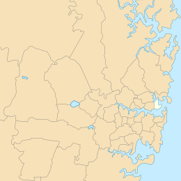
LGAs around Mosman: City of Willoughby Middle Harbour Manly Council North Sydney Council Mosman Sydney Heads City of Sydney Sydney Harbour Municipality of Woollahra The Municipality of Mosman is a Local Government Area on the Lower North Shore of Sydney, in the state of New South Wales, Australia.
Contents
Demographics
According to the Australian Bureau of Statistics[2]
- there were 28,414 people as at 30 June 2006, making it the 70th largest Local Government Area in New South Wales—equal to 0.42% of the New South Wales population of 6,827,694.
- there was an increase of 143 people over the year to 30 June 2006—the 76th largest population growth in a Local Government Area in New South Wales. That represents 0.24% of the 58,753 increase in the population of New South Wales.
- there was an increase of 0.5% in the number of people over the year to 30 June 2006—the 97th fastest growth in population of a Local Government Area in New South Wales. In New South Wales, the population grew by 0.9%.
- there was an increase in population over the ten years to 30 June 2006 of 962 people or 3.5% (0.3% in annual average terms)—the 82nd highest rate of a Local Government Area in New South Wales. In New South Wales, the population grew by 622,966 or 10% (1.0% in annual average terms) over the same period.
Suburbs
In February 1997, the Government Gazette published a notice advising that they had assigned Mosman as the only suburb in the Mosman Local Government Area. However, Mosman Council decided that residents should continue to be allowed to use the traditional locality names if they wished.[3]
Localities in the local government area
The municipality consists entirely of the suburb of Mosman, which includes the following localities:
The municipality also manages and maintains the following locations:
- Middle Head
- Taronga Zoo
- Balmoral Beach, Edwards Beach, Hunters Bay, Rocky Point
- Cobblers Beach, Obelisk Bay
- Chinamans Beach, Wyargine Point, Shell Cove, Parriwi Head, Pearl Bay
- Chowder Head, Chowder Bay, Georges Head
- Bradleys Head, Taylors Bay, Athol Bay, Little Sirius Cove, Mosman Bay
- Long Bay, Quakers Hat Bay
Council
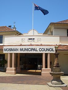
Mosman Municipal Council is composed of nine councillors elected proportionally. The area is divided into three wards, each electing three councillors. The mayor is not directly elected.[4] The current makeup of the council is as follows:[4]
Party Councillors Independents and Unaffiliated 9 Total 9 The current council, elected in 2008, is:[4]
Ward Councillor Party Notes Balmoral Ward Dom Lopez Independent Tom Sherlock Independent Libby Moline Independent Elected on Dom Lopez's ticket Middle Harbour Ward Jim Reid Independent Denise Wilton Independent Warren Yates Unaffiliated Mosman Bay Ward Simon Menzies Independent Deputy Mayor Anne Connon Independent Mayor Belinda Halloran Independent Elected on Simon Menzies' ticket Sister city
Mosman has twin town status with Glen Innes, New South Wales.
Notes
- ^ Australian Bureau of Statistics (30 March 2010). "Regional Population Growth, Australia, 2008–09". http://www.abs.gov.au/ausstats/abs@.nsf/Latestproducts/3218.0Main%20Features42008-09?opendocument&tabname=Summary&prodno=3218.0&issue=2008-09&num=&view=. Retrieved 3 June 2010.
- ^ "Regional Population Growth, Australia, 2005-06 (catalogue no.: 3218.0)". Australian Bureau of Statistics. http://abs.gov.au. Retrieved 2007-03-12.
- ^ Mosman Municipal Council - Ordinary Meeting Agenda - Meeting Date: 29 November 2005 pg 83.
- ^ a b c "Mosman Municipal Council". 2008 Election results. Electoral Commission NSW. http://www.lg.elections.nsw.gov.au/LGE2008/result.Mosman.html. Retrieved 2009-08-02.[dead link]
External links
- Mosman Municipal Council website
- 2001 Census Information
- Community Profile of the Mosman Local Government Area
- Community Atlas of the Mosman Local Government Area
Regions of Sydney Local Government Areas of SydneyAshfield · Auburn · Bankstown · Blacktown · Botany Bay · Burwood · Camden · Campbelltown · Canada Bay · Canterbury · Fairfield · The Hills · Holroyd · Hornsby · Hunter's Hill · Hurstville · Kogarah · Ku-ring-gai · Lane Cove · Leichhardt · Liverpool · Manly · Marrickville · Mosman · North Sydney · Parramatta · Penrith · Pittwater · Randwick · Rockdale · Ryde · Strathfield · Sutherland · City of Sydney · Warringah · Waverley · Willoughby · WoollahraLocal Government Areas of New South Wales Metropolitan Sydney Inner SydneyAshfield · Botany Bay · Burwood · Canada Bay · Canterbury · Hurstville · Kogarah · Lane Cove · Leichhardt · Manly · Marrickville · Mosman · North Sydney · Randwick · Rockdale · Strathfield · Sydney · Waverley · Willoughby · WoollahraOuter SydneyAuburn · Bankstown · Blacktown · Camden · Campbelltown · Fairfield · The Hills · Holroyd · Hornsby · Hunter's Hill · Ku-ring-gai · Liverpool · Parramatta · Penrith · Pittwater · Ryde · Sutherland · WarringahSydney SurroundsMid North Coast Bellingen · Clarence Valley · Coffs Harbour · Greater Taree · Kempsey · Nambucca · Port Macquarie-Hastings · Lord Howe IslandMurray Murrumbidgee Carrathool · Coolamon · Cootamundra · Griffith · Gundagai · Hay · Junee · Leeton · Lockhart · Murrumbidgee · Narrandera · Temora · Wagga WaggaHunter Cessnock · Dungog · Gloucester · Great Lakes · Lake Macquarie · Maitland · Muswellbrook · Newcastle · Port Stephens · Singleton · Upper HunterIllawarra Richmond Tweed Southeastern Bega · Bombala · Boorowa · Cooma-Monaro · Eurobodalla · Goulburn Mulwaree · Harden · Palerang · Queanbeyan · Snowy River · Tumut · Upper Lachlan · Yass Valley · YoungNorthern Armadale Dumaresq · Glen Innes-Severn · Gunnedah · Guyra · Gwydir · Inverell · Liverpool Plains · Moree Plains · Narrabri · Tamworth · Tenterfield · Uralla · WalchaCentral West North Western Far West Categories:- Sydney geography stubs
- Local Government Areas in Sydney
Wikimedia Foundation. 2010.

