- City of Greater Taree
-
Greater Taree
New South Wales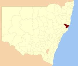
Location in New South WalesPopulation: 48,503(2009)[1] • Density: 12.10/km² (31.3/sq mi) Area: 3730 km² (1,440.2 sq mi) Mayor: Paul Hogan[2] Council Seat: Taree (Breese Parade} Region: Mid North Coast State District: Myall Lakes, Port Macquarie, Oxley Federal Division: Lyne LGAs around Greater Taree: Walcha Port Macquarie-Hastings Pacific Ocean Gloucester Greater Taree Pacific Ocean Gloucester Great Lakes Pacific Ocean The City of Greater Taree is a Local Government Area on the Mid North Coast of New South Wales, Australia, centered on Taree. It is on the Manning River, the Pacific Highway and the North Coast railway line.
Contents
History
The first movement to establish a City of Greater Taree began in November 1959. The Taree Municipal Council applied to the Department of Local Government to extend its boundaries to the coastal area between Old Bar and Seal Rocks.[3]
At an inquiry of the Boundaries Commission at Taree in 1976, the Dungog Shire proposed that the areas covered by the shires of Dungog, Gloucester, Great Lakes and Manning and the municipalities of Taree and Wingham be combined into two areas "to elevate local government to its proper role". At this stage, Taree Municipal Council proposed only their merger with the Municipality of Wingham. A decision was postponed for 5 years.[3]
On 1 January 1981, the City of Greater Taree was proclaimed, encompassing the Municipalities of Taree and Wingham and the Manning Valley Shire.[3] [4]
Towns and localities
- Bobin
- Bohnock
- Brinawa
- Cedar Party
- Coopernook
- Coralville
- Croki
- Crowdy Head
- Cundletown
- Dumaresq Island
- Dyers Crossing
- Elands
- Ghinni Ghinni
- Glenwarrin
- Hallidays Point
- Hannam Vale
- Harrington
- Johns River
- Jones Island
- Kippax
- Kolodong
- Koorainghat
- Krambach
- Langley Vale
- Lansdowne
- Manning Point
- Marlee
- Mitchells Island
- Mooral Creek
- Moorland
- Nabiac
- Old Bar
- Oxley Island
- Pampoolah
- Possum Brush
- Rawson River
- Rocks Crossing
- Stewarts River
- Tinonee
- Waitui
- Wallabi Point
- Wherrol Flat
- Wingham
Demographics
In the 2006 Census of Population and Housing there were 45,145 usual residents living in the City of Greater Taree. Of this count, 22,077 (or 49%) were males and 23,068 (or 51%) were females.
By age, 20% of the population was under 15 years old, 61% were between 15 and 65, and 19% were over 65 years old.
Most people living in Greater Taree were born in Australia (93%). The median age was 43 years.
Economy
According to the 2006 Census of Population and Housing, the median invididual income was $336 per week (equal to approximately $17,520 per year). The median family income in 2006 was $798 per week (equal to approximately $41,610 per year); and, the median household income in 2006 was $635 per week (equal to approximately $33,111 per year).
There were 15,977 people employed in 2006 (to give an employment to working age population ratio of 0.58), and 1,884 people unemployed. The most common occupations were Technicians and Trades Workers (16%); Labourers (15%); and, Professionals (15%). The top 5 industries for employment were School Education (5.9%); Hospitals (5.3%); Cafes, Restaurants and Takeaway Food Services (3.4%); Supermarket and Grocery Stores (3.0%); and, Residential Care Services (2.9%).
Housing
In the 2006 Census of Population and Housing, the median housing loan repayment was $1,083 per month. This equated to marginally under 43% of median household income.
The median rent in 2006 was $150 per week. This equated to just under 24% of median household income.
The average household size was 2.4 persons.
Council
Greater Taree City Council is composed of eight councillors elected proportionally, in addition to the mayor, who is directly elected.[5] The current makeup of the council, including the mayor, is as follows:[5]
Party Councillors Independents and Unaffiliated 9 Total 9 The current council, elected in 2008, is:[5]
Councillor Party Notes Paul Hogan Independent Mayor Mal Marks Independent Deputy Mayor Eddie Loftus Unaffiliated Trent Jennison Independent Elected on Paul Hogan's ticket David West Independent Mave Richardson Independent Kathryn Bell Independent Elected on Mal Marks's ticket David Keegan Independent Alan Tickle Independent References
- ^ Australian Bureau of Statistics (30 March 2010). "Regional Population Growth, Australia, 2008–09". http://www.abs.gov.au/ausstats/abs@.nsf/Latestproducts/3218.0Main%20Features42008-09?opendocument&tabname=Summary&prodno=3218.0&issue=2008-09&num=&view=. Retrieved 3 June 2010.
- ^ "Greater Taree City Council". Department of Local Government. http://www.dlg.nsw.gov.au/dlg/dlghome/dlg_CouncilContactDetails.asp?slacode=3350. Retrieved 2009-05-16.
- ^ a b c Ramsland, John (1987). The Struggle Against Isolation - A History of the Manning Valley. North Sydney, New South Wales: Library of Australian History. pp. 300–301. ISBN 0-908120-67-2.
- ^ "Taree". The Age website. The Age Company Ltd.. 2007-08-16. http://www.theage.com.au/news/new-south-wales/taree/2005/02/17/1108500199414.html. Retrieved 2008-10-07.
- ^ a b c "Greater Taree City Council". 2008 Election results. Electoral Commission NSW. http://www.lg.elections.nsw.gov.au/LGE2008/result.Greater_Taree.html. Retrieved 2009-06-17.[dead link]
Local Government Areas of New South Wales Metropolitan Sydney Inner SydneyAshfield · Botany Bay · Burwood · Canada Bay · Canterbury · Hurstville · Kogarah · Lane Cove · Leichhardt · Manly · Marrickville · Mosman · North Sydney · Randwick · Rockdale · Strathfield · Sydney · Waverley · Willoughby · WoollahraOuter SydneyAuburn · Bankstown · Blacktown · Camden · Campbelltown · Fairfield · The Hills · Holroyd · Hornsby · Hunter's Hill · Ku-ring-gai · Liverpool · Parramatta · Penrith · Pittwater · Ryde · Sutherland · WarringahSydney SurroundsMid North Coast Bellingen · Clarence Valley · Coffs Harbour · Greater Taree · Kempsey · Nambucca · Port Macquarie-Hastings · Lord Howe IslandMurray Murrumbidgee Carrathool · Coolamon · Cootamundra · Griffith · Gundagai · Hay · Junee · Leeton · Lockhart · Murrumbidgee · Narrandera · Temora · Wagga WaggaHunter Cessnock · Dungog · Gloucester · Great Lakes · Lake Macquarie · Maitland · Muswellbrook · Newcastle · Port Stephens · Singleton · Upper HunterIllawarra Richmond Tweed Southeastern Bega · Bombala · Boorowa · Cooma-Monaro · Eurobodalla · Goulburn Mulwaree · Harden · Palerang · Queanbeyan · Snowy River · Tumut · Upper Lachlan · Yass Valley · YoungNorthern Armadale Dumaresq · Glen Innes-Severn · Gunnedah · Guyra · Gwydir · Inverell · Liverpool Plains · Moree Plains · Narrabri · Tamworth · Tenterfield · Uralla · WalchaCentral West North Western Far West

Wikimedia Foundation. 2010.