Lansdowne, New South Wales
- Lansdowne, New South Wales
Infobox Australian Place | type = suburb
name = Lansdowne
city = Sydney
state = nsw
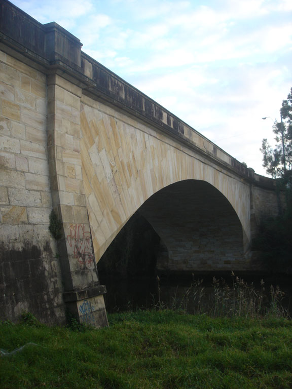
caption = Lansdowne Bridge over Prospect Creek on the Hume Highway
lga = City of Bankstown
postcode = 2163
est =
pop =
area =
propval =
stategov = Bankstown
fedgov = Blaxland
near-nw = Canley Vale
near-n = Carramar
near-ne = Villawood
near-w = Lansvale
near-e = Bass Hill
near-sw = Lansvale
near-s = Georges Hall
near-se = Georges Hall
dist1 = 27
dir1 = west
location1= Sydney CBD
Lansdowne is a suburb in south-western Sydney, in the state of New South Wales, Australia. Lansdowne is located 27 kilometres west of the Sydney central business district, in the local government areas of the City of Bankstown and is part of the South-western Sydney region.
History
Lansdowne took its name from the Lansdowne Bridge which was named by Governor Richard Bourke to honour Henry Petty-Fitzmaurice, 3rd Marquess of Lansdowne (1780-1863), a Whig politician.
The Landsdowne Bridge was built in 1834-35 from stone quarried on the banks of the Georges River. It replaced a hardwood bridge called Bowler’s Bridge because it led to Bowler’s Inn. The Lansdowne Bridge was one of the finest works by Scottish stonemason David Lennox (1788-1873), who arrived in Sydney in 1832 and was made Superintendent of Bridges with the task of replacing hardwood bridges that were frequently swept away in floods.
Many minor roads in the area bounded by the Hume Highway, Prospect Creek and Hazel Street have been resumed to form the Mirambeena Regional Park and Lansdowne Park, which boast pedestrian/cycle-paths, a number of man-made lakes, recreational reserves and a quality restaurant.
Note that this suburb's name has occasionally in the past appeared on maps with a spelling of 'Landsdowne'. [ "The Book of Sydney Suburbs", Compiled by Frances Pollen, Angus & Robertson Publishers, 1990, Published in Australia ISBN 0-207-14495-8]
Transport
Historic Lansdowne Bridge is a sandstone bridge built by David Lennox that (from 1957) carries northbound-only traffic of the Hume Highway over Prospect Creek which opened in 1836.
Henry Lawson Drive runs along the western border of Lansvale, through Mirambeena Regional Park.
Parks
* Lansdowne Park features a road cycling circuit.
* Mirambeena Regional Park sits beside Prospect Creek
References
External links
Wikimedia Foundation.
2010.
Look at other dictionaries:
Lansdowne (village), New South Wales — Lansdowne is a rural village on the Mid North Coast near Taree in New South Wales, Australia. The village lies in the Lansdowne River valley, adjacent to the Coorabakh National Park, as well as Coopernook and the Lansdowne State Forests. It is… … Wikipedia
New South Wales Waratahs — For the field hockey team, see New South Wales Waratahs (field hockey). New South Wales Waratahs Union Australian Rugby Union Nickname(s) Tahs Founded … Wikipedia
New South Wales Rugby Union — Not to be confused with New South Wales Rugby League. The New South Wales Rugby Union (NSWRU) is the organisation responsible for the sport of rugby union in most of the state of New South Wales, Australia. The Sydney Rugby Union, New South Wales … Wikipedia
Lansvale, New South Wales — Infobox Australian Place | type = suburb name = Lansvale city = Sydney state = nsw caption = Floyd Bay lga = City of Fairfield postcode = 2166 est = pop = area = propval = stategov = Cabramatta fedgov = Blaxland near nw = Canley Vale near n =… … Wikipedia
Tahlee, New South Wales — Infobox Australian Place type = suburb name = Tahlee city = state = nsw imagesize = caption = pop = pop footnotes = density = density footnotes = est = 1826 postcode = 2324 coordinates = coord|32|39|38|S|152|00|07|E|type:town region:AU… … Wikipedia
Broke, New South Wales — Broke is a village of approximately 400 people in the Hunter Valley region of New South Wales, Australia in Singleton Shire. It is located 157 kilometres to the north of Sydney on the original early colonial road from Sydney to Singleton (26… … Wikipedia
Singleton, New South Wales — Infobox Australian Place | type = town name = Singleton state = nsw caption = Location of Singleton in New South Wales (red) lga = Singleton Shire Council postcode = 2330 est = pop = 13,665 elevation= 40 maxtemp = 24.7 mintemp = 11.1 rainfall =… … Wikipedia
Coopernook, New South Wales — Coopernook is a village in mid north New South Wales, Australia (post code 2426). It is located 24 kilometres north of Taree and 11 kilometres west of Harrington and is administered by Greater Taree City Council. At the 2006 census, Coopernook… … Wikipedia
Lithgow, New South Wales — Infobox Australian Place | type = city name = Lithgow state = nsw caption = Blast Furnace Park, Lithgow lga = City of Lithgow postcode = 2790 pop = 11,298 pop footnotes=Census 2006 AUS|id=UCL148200|name=Lithgow (Urban… … Wikipedia
Mosman, New South Wales — Mosman Sydney, New South Wales Conservation area shop fronts, Military Road Population … Wikipedia