- Hannam Vale, New South Wales
Infobox Australian Place | type = town
name = Hannam Vale
state = nsw
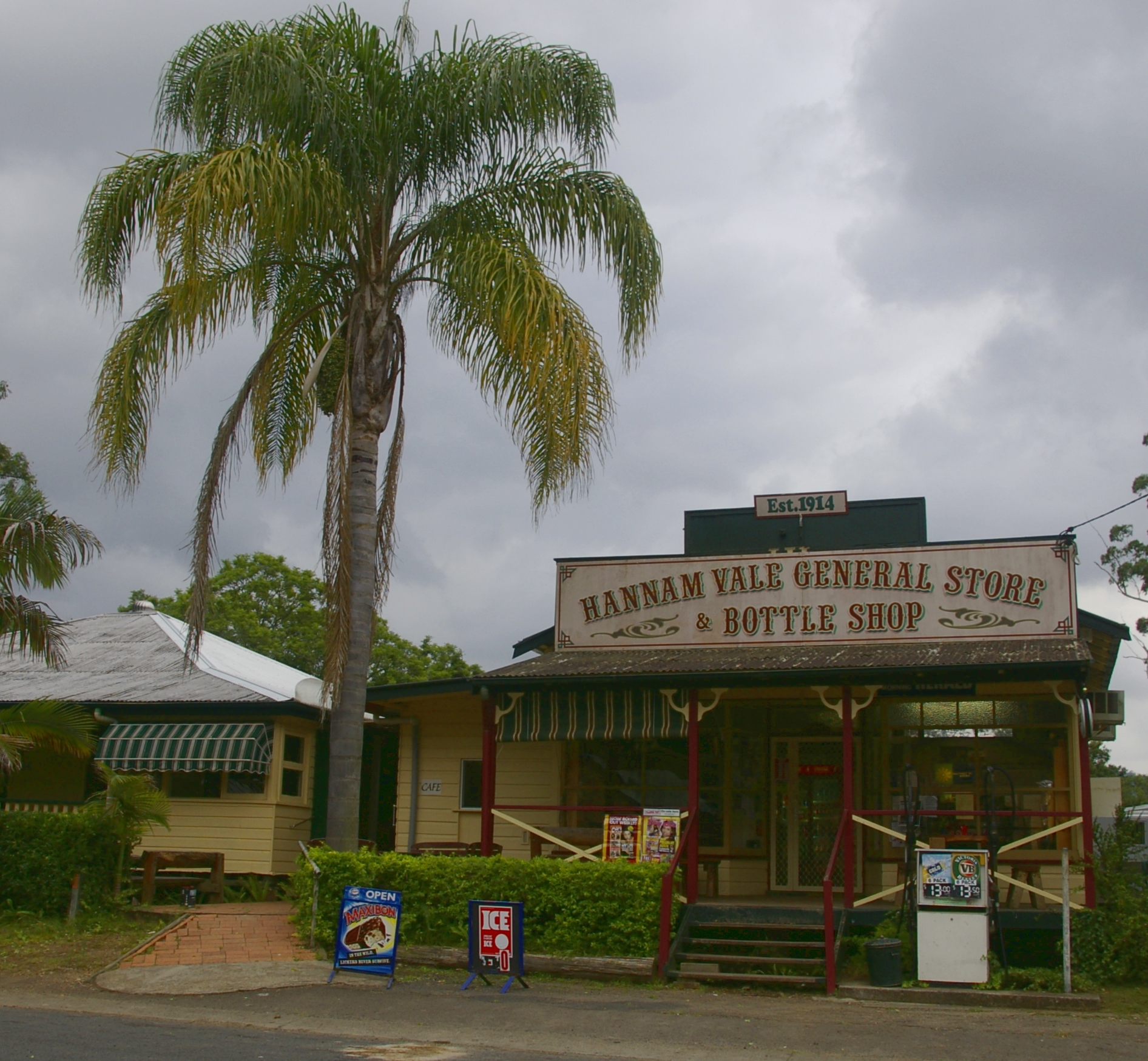
caption = General store at Hannam Vale
lga =City of Greater Taree
postcode =
est =
pop = 345
pop_footnotes = [ [http://www.censusdata.abs.gov.au/ABSNavigation/prenav/LocationSearch?locationLastSearchTerm=hannam+vale&locationSearchTerm=hannam+vale&newarea=SSC17463&submitbutton=View+QuickStats+%3E&mapdisplay=on&collection=Census&period=2006&areacode=SSC17463&geography=&method=Place+of+Usual+Residence&productlabel=&producttype=QuickStats&topic=&navmapdisplayed=true&javascript=true&breadcrumb=PL&topholder=0&leftholder=0¤taction=104&action=401&textversion=false&subaction=1 Australian Bureau of Statistics. "2006 Census QuickStats : Hannam Vale (State Suburb)."] Retrieved 2008-10-07]
elevation= 64
maxtemp =
mintemp =
rainfall =
stategov = Port Macquarie
fedgov = Lyne
dist1 = 344
dir1 = N
location1=Sydney
dist2 = 40
dir2 = N
location2=TareeHannam Vale is a small village located in a forestry and dairy farming area on the Mid North Coast, about Convert|25|mi|km North-West of Taree in
New South Wales ,Australia .History
Thirty years after the
penal colony was established atSydney ,John Oxley , the colony's surveyor-general surveyed the Hastings andManning River valleys for settlement. Soon after,woodcutter s in search of the highly prized red cedar, pushed into the Stewarts River valley and the densely-wooded valley that subsequently become known as Hannam Vale.The first recorded selection of land was by Thomas Crossingham in the Stewarts River area in 1866. G.A Scott chose a block of 40 acres in 1873, but was unable to complete the purchase, so the block was re
gazette d in 1886 and purchased by J. H. Lambert. The first permanent settler in the valley was John Haydon who purchased 50 acres along the Stewarts River in 1882. Haydon's son Bill became known locally as the 'Cedar King'. He was the first woodcutter to use a truck as a hauler during the 1930s.Other settlers with surnames such as Anderson, Brewer, Buttsworth, Holden, Joyce, Lambert, Mooney, Powell, Redman, Sheather, Watts and Ward, followed the woodcutters into the valley, clearing land for growing crops such as
maize ,arrowroot ,potatoe s and vegetables. Most of the early settlers also planted a variety of fruit trees, especially oranges, and kept cattle fordairy farming . By the mid 1930's,dairy farming andlogging had become the principal activities in the larger Hannam Vale area of Stewarts River, Hannam Vale and Waitui.Hannam Vale was given its name by Francis Redman, who operated the
post office . When he found that the name "Upper Stewarts River" was too long to fit on the mail stamp, he used his farm's name, "Hannam Vale", instead. Redman was also instrumental in having the Hannam Vale School's first teacher appointed by providing a residence on his property. Redmond's son subsequently provided a half acre block of land on which the Hannam Vale Community Hall was erected.The primary school was first established as a one-teacher "provisional" school in 1899. It was afforded permanent status and its original buildings erected in 1907; since then a number of other buildings have been added. Most recently, a small building used as a church in Waitui was donated to the School and is now used as a community centre and library. The
public school is known throughout the wider Mid North Coast for the legend on its school gate: Quotation|"Through this gate walk the nicest people in the world".Present day
As dairy farming has become less lucrative, so more people have begun to use the valley purely for residential purposes, either working close by, or commuting to jobs in the nearby towns of
Taree andPort Macquarie . More recently, followingderegulation of the dairy industry in 2001, a number of the older dairy farms have ceased to operate; this has been closely associated with growing numbers of "city folk" purchasing smaller lots for recreational farming, as well as the establishment ofbed and breakfast accommodation in the area.The region's high rainfall and dairy farming legacy, along with associated planting of
grass es such as kikuyu, is the reason for the present day lush-green landscape.The "epicentre" of Hannam Vale is the junction of Hannam Vale Road and deep Creek Road, ten minutes from the Pacific Highway at Johns River or Moorland. The most prominent features of this area are the public school, general store,
Salvation Army chapel and community centre.Opposite the Public School is the Hannam Vale General Store. Built in 1927 the store is a social centre of the wider Hannam Vale area.
Just east of the Public School is the Rural Fire Service meeting room and further east again, off Hannam Vale Road, is the entrance way to the Hannam Vale Recreational Reserve. Just two to three hundred metres to the north-west of the School on Hannam Vale Road is the Hannam Vale Community Hall the home of community meetings in the area as well as special events such as dances, art exhibitions and fundraising activity.
Around the corner from the Public School in Deep Creek Road is the original
Salvation Army Chapel and newly built Community Hall.Present day farming activities include
beef cattle , small scaledairying , andmacadamia nut s. Commercialforestry also continues, with the Lansdowne State Forest bordering the village.Several national parks border the area. In particular,
Coorabakh National Park has waterfalls, and spectacular panoramic views from lookouts such Flat Top Rock.NOTABLE RESIDENTS
Michael Cross
Further reading
*cite book|title=John's River, Stewart's River and Hannam Vale: Chronicles of the Early Days|author=Rodney John Gow, Wendy Gow|date=2007|publisher=R and W Gow|isbn=0980383269|url=http://books.google.com/books?id=qCCOKQAACAAJ
References
External links
* [http://www.hannamvale.com Hannam Vale]
Wikimedia Foundation. 2010.