- City of Hurstville
-
City of Hurstville
New South Wales
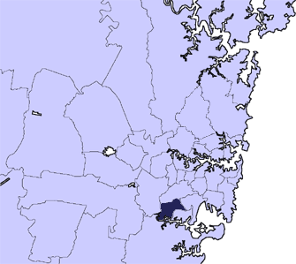
Population: 79,648(2009)[1] • Density: 3300/km² (8,547.0/sq mi) Area: 23 km² (8.9 sq mi) Mayor: Steve McMahon Council Seat: Hurstville Region: Metropolitan Sydney State District: Oatley, Kogarah, Lakemba Federal Division: Banks, Barton LGAs around City of Hurstville: City of Rockdale City of Canterbury City of Hurstville Municipality of Kogarah City of Bankstown Sutherland Shire 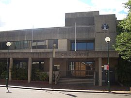 Council Chambers, MacMahon Street, Hurstville
The City of Hurstville is a Local Government Area in southern Sydney, in the state of New South Wales, Australia. The city centre is located 17km SSW of the Sydney central business district and west of Botany Bay.
The city is part of the St George area, which contains the three local government areas of Hurstville, Kogarah and Rockdale.
Hurstville Municipality was incorporated in 1887. Hurstville was declared a city in 1988.
Contents
Suburbs in the local government area
Suburbs in the City of Hurstville are:
- Beverly Hills
- Hurstville
- Kingsgrove
- Lugarno
- Mortdale
- Narwee
- Oatley
- Peakhurst
- Peakhurst Heights
- Penshurst
- Riverwood
- Roselands
Hurstville City Council also manages and maintains the following localities:- Boggywell Creek
- Edith Bay
- Gertrude Point
- Gungah Bay
- Westfield Hurstville
- Hurstville Bay
- Jew Fish Bay
- Jew Fish Point
- Kingsway
- Lime Kiln Bay
- Lime Kiln Head
- Oatley West
- Soilybottom Point
Population statistics
According to the Australian Bureau of Statistics, Hurstville had a population of 70,643 in 2001.
Council
Hurstville City Council is composed of twelve councillors elected proportionally. The city is divided into three wards, each electing four councillors. The mayor is not directly elected.[2] The current makeup of the council is as follows:[2]
Party Councillors Australian Labor Party 5 Liberal Party of Australia 3 Independents 2 The Greens 1 Unity Party 1 Total 12 The current council, elected in 2008, is:[2]
Ward Councillor Party Notes Hurstville Vince Badalati Labor Andrew Istephan Liberal Clifton Wong Labor Nancy Liu Unity Peakhurst Philip Sansom Labor Mayor Jack Jacovou Liberal Anne Wagstaff Greens Bill Pickering Independent Penshurst Steve McMahon Labor Con Hindi Liberal Deputy Mayor David Perry Labor Bev Giegerl Independent References
- ^ Australian Bureau of Statistics (30 March 2010). "Regional Population Growth, Australia, 2008–09". http://www.abs.gov.au/ausstats/abs@.nsf/Latestproducts/3218.0Main%20Features42008-09?opendocument&tabname=Summary&prodno=3218.0&issue=2008-09&num=&view=. Retrieved 3 June 2010.
- ^ a b c "Hurstville City Council". 2008 Election results. Electoral Commission NSW. http://www.lg.elections.nsw.gov.au/LGE2008/result.Hurstville.html. Retrieved 2009-06-17.[dead link]
External links
- City of Hurstville website
- City of Hurstville Community Information Webpage
- City of Hurstville Library and Information Service
- Map of Ward Boundaries in Hurstville LGA
- 2001 Census Information
- Hurstville City Business Directory
Regions of Sydney Local Government Areas of Sydney Ashfield · Auburn · Bankstown · Blacktown · Botany Bay · Burwood · Camden · Campbelltown · Canada Bay · Canterbury · Fairfield · The Hills · Holroyd · Hornsby · Hunter's Hill · Hurstville · Kogarah · Ku-ring-gai · Lane Cove · Leichhardt · Liverpool · Manly · Marrickville · Mosman · North Sydney · Parramatta · Penrith · Pittwater · Randwick · Rockdale · Ryde · Strathfield · Sutherland · City of Sydney · Warringah · Waverley · Willoughby · WoollahraList of Sydney suburbs Local Government Areas of New South Wales Metropolitan Sydney Inner SydneyAshfield · Botany Bay · Burwood · Canada Bay · Canterbury · Hurstville · Kogarah · Lane Cove · Leichhardt · Manly · Marrickville · Mosman · North Sydney · Randwick · Rockdale · Strathfield · Sydney · Waverley · Willoughby · WoollahraOuter SydneyAuburn · Bankstown · Blacktown · Camden · Campbelltown · Fairfield · The Hills · Holroyd · Hornsby · Hunter's Hill · Ku-ring-gai · Liverpool · Parramatta · Penrith · Pittwater · Ryde · Sutherland · WarringahSydney SurroundsMid North Coast Bellingen · Clarence Valley · Coffs Harbour · Greater Taree · Kempsey · Nambucca · Port Macquarie-Hastings · Lord Howe IslandMurray Murrumbidgee Carrathool · Coolamon · Cootamundra · Griffith · Gundagai · Hay · Junee · Leeton · Lockhart · Murrumbidgee · Narrandera · Temora · Wagga WaggaHunter Cessnock · Dungog · Gloucester · Great Lakes · Lake Macquarie · Maitland · Muswellbrook · Newcastle · Port Stephens · Singleton · Upper HunterIllawarra Richmond Tweed Southeastern Bega · Bombala · Boorowa · Cooma-Monaro · Eurobodalla · Goulburn Mulwaree · Harden · Palerang · Queanbeyan · Snowy River · Tumut · Upper Lachlan · Yass Valley · YoungNorthern Armadale Dumaresq · Glen Innes-Severn · Gunnedah · Guyra · Gwydir · Inverell · Liverpool Plains · Moree Plains · Narrabri · Tamworth · Tenterfield · Uralla · WalchaCentral West North Western Far West Categories:- Local Government Areas in Sydney

Wikimedia Foundation. 2010.