- Cooma-Monaro Shire
-
Cooma-Monaro
New South Wales
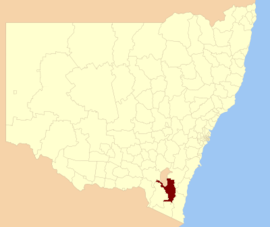
Location in New South WalesPopulation: 10,416(2009)[1] Area: 5229 km² (2,018.9 sq mi) Mayor: Dean Lynch Council Seat: Cooma (81 Commissioner Street)[2] Region: Monaro region State District: Monaro Federal Division: Eden-Monaro LGAs around Cooma-Monaro: Tumut ACT Palerang Snowy River Cooma-Monaro Eurobodalla Snowy River Bombala Bega Valley Cooma-Monaro Shire is a Local Government Area (LGA) in southern New South Wales, named after the former Cooma Municipality and the former Monaro Shire (itself named after the Monaro Region), which were amalgamated to create it. On 11 February 2004, it absorbed a small part of the former Yarrowlumla Shire, near Michelago.
The Shire developed from the village of Cooma, which was first surveyed in March 1849. It also includes the small towns of Nimmitabel, Numeralla, Bredbo and Michelago. Other populated areas include the villages and surrounding districts of Shannons Flat, Yaouk, Peak View, Countegany, Jerangle and Rock Flat.
The current[when?] General Manager of Cooma-Monaro Shire is John Vucic.
Council
Cooma-Monaro Shire Council is composed of nine councillors elected proportionally. The mayor is not directly elected.[3] The current makeup of the council is as follows:[3]
Party Councillors Independents and Unaffiliated 9 Total 9 The current council, elected in 2008, is:[3]
Councillor Party Notes Vacant Dean Lynch Unaffiliated Mayor Jenny Lawlis Independent Roger Norton Unaffiliated Stephanie McDonald Independent Jack Nott Independent Winston Phillips Independent Tony Kaltoum Independent Martin Hughes Independent References
- ^ Australian Bureau of Statistics (30 March 2010). "Regional Population Growth, Australia, 2008–09". http://www.abs.gov.au/ausstats/abs@.nsf/Latestproducts/3218.0Main%20Features42008-09?opendocument&tabname=Summary&prodno=3218.0&issue=2008-09&num=&view=. Retrieved 3 June 2010.
- ^ "Cooma-Monaro Shire Council". Department of Local Government. http://www.dlg.nsw.gov.au/dlg/dlghome/dlg_CouncilContactDetails.asp?slacode=2060. Retrieved 2006-11-13.
- ^ a b c "Cooma-Monaro Shire Council". 2008 Election results. Electoral Commission NSW. http://www.lg.elections.nsw.gov.au/LGE2008/result.Cooma-Monaro.html. Retrieved 2009-06-16.[dead link]
Coordinates: 36°14′S 149°07′E / 36.233°S 149.117°E
Local Government Areas of New South Wales Metropolitan Sydney Inner SydneyAshfield · Botany Bay · Burwood · Canada Bay · Canterbury · Hurstville · Kogarah · Lane Cove · Leichhardt · Manly · Marrickville · Mosman · North Sydney · Randwick · Rockdale · Strathfield · Sydney · Waverley · Willoughby · WoollahraOuter SydneyAuburn · Bankstown · Blacktown · Camden · Campbelltown · Fairfield · The Hills · Holroyd · Hornsby · Hunter's Hill · Ku-ring-gai · Liverpool · Parramatta · Penrith · Pittwater · Ryde · Sutherland · WarringahSydney SurroundsMid North Coast Bellingen · Clarence Valley · Coffs Harbour · Greater Taree · Kempsey · Nambucca · Port Macquarie-Hastings · Lord Howe IslandMurray Murrumbidgee Carrathool · Coolamon · Cootamundra · Griffith · Gundagai · Hay · Junee · Leeton · Lockhart · Murrumbidgee · Narrandera · Temora · Wagga WaggaHunter Cessnock · Dungog · Gloucester · Great Lakes · Lake Macquarie · Maitland · Muswellbrook · Newcastle · Port Stephens · Singleton · Upper HunterIllawarra Richmond Tweed Southeastern Bega · Bombala · Boorowa · Cooma-Monaro · Eurobodalla · Goulburn Mulwaree · Harden · Palerang · Queanbeyan · Snowy River · Tumut · Upper Lachlan · Yass Valley · YoungNorthern Armadale Dumaresq · Glen Innes-Severn · Gunnedah · Guyra · Gwydir · Inverell · Liverpool Plains · Moree Plains · Narrabri · Tamworth · Tenterfield · Uralla · WalchaCentral West North Western Far West Categories:- Local Government Areas of New South Wales
- New South Wales geography stubs
Wikimedia Foundation. 2010.
