- Manning River
-
Manning River
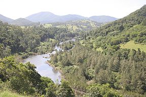
The Manning River upstream of Mount GeorgeOrigin Barrington Tops Mouth Pacific Ocean at Old Bar and Harrington/Manning Point Basin countries Australia Length 250 km Basin area 8,190 km² [1] The Manning River is a river in the Mid North Coast of New South Wales, Australia that flows through the Manning Valley. It is one of Australia's few large river systems not to be dammed for water supply purposes anywhere along its catchment. The local water supply is fed by Bootawa Dam, which is an offsite dam, however, water is pumped from the river to the dam whenever river turbidity and flow levels can allow.
A small weir exists on the upper most section of the Barnard River and is the Barnard River Scheme for Bayswater Power Station the scheme is shutdown until needed but as of 2006 this Scheme was partly decommissioned due to its rare use.
The lower part of the river is a delta system where it meets the sea, with several channels dividing coastal land into large islands, such as Mitchells and Oxley Islands.
Contents
History
In 1818, John Oxley crossed and named Harrington and Farquhar inlets during a trip from the Hastings River, near Port Macquaire, to Port Stephens. The Manning River itself was first surveyed by Henry Dangar in 1825 and again in 1826 on behalf of the Australian Agricultural Company. The river was recorded on the survey map as "Boolumbahtee," its Aboriginal name.
Later in 1826, the river was named Mannings River for the Deputy Governor of the Australian Agricultural Company, Sir William Manning. In the same year it was declared that the Manning was the northern limit of the Nineteen Counties, defining the areas of New South Wales where settlers were free to occupy.
Until 1913, ships servicing the coast brought goods and supplies up the river.
Geography
The Manning River is fed by the Avon River, Rowley's River, the Nowendoc River, the Barnard River, the Little Manning River, and the Barrington River, which flows through Gloucester. Once the river reaches Taree it splits and the southern arm flows into the Pacific Ocean at Old Bar. The northern arm is joined by the Dawson River and the Landsdowne River and meets the ocean at Harrington Hence the river has two separate entrances (or mouths).
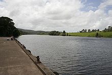
Wingham was established at the furthest point supply boats could reach up the river and became the regions major port. The old cargo wharf at Wingham Brush has been recently refurbished. The town of Tinonee was also settled on the river near Taree.
The Manning River is the only double delta river in the southern Hemisphere and the only permanent multiple entrance river in the world other than the Nile River Egypt. The Manning is one of only a few Australian mainland rivers to receive annual winter melting snow deposits. These deposits flow from its tributary the Barrington River in Barrington Tops Mountains into the Manning.
Ecology
The Manning River is a large producer of Australian oysters and is home to many fish, the most common being the Dusky Flathead (Platycephalus fuscus), a common Australian estuary fish. The Manning River is frequented by dolphins and sharks, with some venturing as far up the river to Wingham.
Whales also frequent the river, mainly at the larger Harrington inlet, although some do enter the Farquar inlet and generally do not venture far up river. However, on 16 September 1994 a rare tropical Bryde's whale measuring 9-metre (30 ft) long, nicknamed "Free Willy" by locals, ventured much further up river to Taree where the river is freshwater. After becoming a tourist attraction, and repeatedly evading attempts by conservationists to free him "Free Willy" finally left the Manning River 92 days later of his own free will.[2]
Events
Taree is home to the annual Manning River Summer Festival, which features rowing, and sailing. The Taree Powerboat Club Spectacular is held in the Manning River during the Easter long weekend. The link between Taree and the oyster industry is shown by the presence in Taree of the "Big Oyster", a building constructed in the shape of an open oyster shell.
Industry
Tourist trips are popular on the Manning.
Commercial fishing and oyster farming are both practiced in the Manning. The peak season for oyster production is September to March and average yearly production is 310,755 dozen.[citation needed]
See also
References
- ^ "Manning River: Assessment of River Condition - New South Wales". Australian Natural Resources Atlas. http://www.anra.gov.au/topics/water/condition/nsw/basin-manning-river.html. Retrieved 2008-01-22.
- ^ Associated Press (17 November 2004). "Australians trying to free whale Willy". Eugene Register-Guard. http://news.google.com/newspapers?nid=1310&dat=19941117&id=JHkVAAAAIBAJ&sjid=w-sDAAAAIBAJ&pg=5181,4093472. Retrieved 19 May 2010.
External links
Coordinates: 31°52′S 152°38′E / 31.867°S 152.633°E
Towns, suburbs and localities of Gloucester Shire | Hunter Region | New South Wales Towns, suburbs
& localitiesBack Creek • Bakers Creek • Barrington • Baxters Ridge • Belbora • Bennys Tops • Berrico • Bindera • Bowman • Bowman Farm • Bretti • Bulliac • Bundook • Callaghans Creek • Caramea • Cobark • Coneac • Copeland • Corroboree Flat • Craven • Craven Plateau • Cravens Creek • Cundle Flat • Curricabark • Dewitt • Doon Ayre • Faulkland • Forbesdale • Gangat • Giro • Glen Ward • Gloucester • Gloucester River • Gloucester South • Gloucester Tops • Heatherdale • Invergordon • Kauthi • Kia Ora • Lower Bowman • Mares Run • Maudville • Mernot • Mograni • Mograni Creek • Moppy • Mount Peerless • Myra • Pitlochry • Rawdon Vale • Rocky Crossing • Rookhurst • Stratford • Stratford South • Taravale • Tibbuc • Titaatee Creek • Tugrabakh • Upper Bowman • Wallanbah • Wapra • Waukivory • Waukivory Upper • Wirradgurie • Woko • Yumbunga
Other places &
points of interestAvon River • Gloucester River • Manning River
Towns, suburbs and localities of Great Lakes Council | Hunter & Mid North Coast Regions | New South Wales Towns, suburbs
& localitiesAllworth • Bulahdelah • Bungwahl • Dungog • Failford • Forster • Hawks Nest • Karuah • Monkerai • Nabiac • North Arm Cove • Pacific Palms • Seal Rocks • Smiths Lake • Stroud • Tahlee • Tea Gardens • Tuncurry
Other places &
points of interestBooti Booti National Park • Broughton Island • Cape Hawke • Ghin-Doo-Ee National Park • Karuah River • Manning River • Myall Lakes • Myall Lakes National Park • Myall River • Port Stephens • Singing Bridge • Tahlee historic property • Tops to Myall Heritage Trail • Wallingat National Park
Significant places and items of interest in the Hunter Region of New South Wales Commerce and industry IndustryDarley Stud • Hunter Valley Coal Chain • Hunter Valley wine • Kia-Ora stud • Kooragang Island • Newcastle Port Corporation • Tomago aluminium smelterShoppingOtherEducation PrimarySecondaryAll Saints College, St Joseph's Campus • Avondale School • Hunter School of the Performing Arts • Hunter Valley Grammar School • Irrawang High School • Lambton High School • Maitland Grossmann High School • Maitland High School • Merewether High School • Newcastle Grammar School • Newcastle High School • Rutherford Technology High School • Tomaree High SchoolTertiaryEntertainment, sport & culture Broadmeadow Basketball Stadium • Dungog Film Festival • Hunter Valley Steamfest • Newcastle Civic Theatre • Newcastle Entertainment Centre • Newcastle International Sports Centre • Newcastle Number 1 Sports Ground • Newcastle Regional ShowGeography GeneralBroughton Island • Burning Mountain • Cape Hawke • Glenrock Lagoon • Lake Macquarie • Myall Lakes • Mount Royal Range • Mount Sugarloaf • Port Stephens • Stockton Beach • Tops to Myall Heritage TrailNational parksBarrington Tops National Park • Black Bulga State Conservation Area • Booti Booti National Park • Ghin-Doo-Ee National Park • Mount Royal National Park • Myall Lakes National Park • Tomaree National Park • Towarri National Park • Wallingat National Park • Watagans National Park • Werakata National ParkRiversAvon River • Barrington River • Chichester River • Gloucester River • Goulburn River • Hunter River • Karuah River • Manning River • Myall River • Pages River • Paterson River • Williams RiverHistorical Air transportDefenceEducationGeneralHistory of Newcastle, New South Wales • Hunter Valley cannabis infestation • Lake Macquarie Petrified Forest • Maitland Gaol • Nobbys Head • Royal Newcastle Hospital • Tahlee historic propertyIndustryCockle Creek Power Station • Cockle Creek Smelter • South Maitland coalfields • South Waratah Colliery • State Dockyard • Teralba Colliery • Walka Water Works • Wangi Power StationMaritimeNatural disasters1989 Newcastle earthquake • June 2007 Hunter Region and Central Coast storms • Seaham bushfires (1939)PeopleRailGeneralRailway linesBelmont railway line • East Maitland – Morpeth railway line • Fernleigh Track • Richmond Vale Railway • South Maitland Railway • Toronto railway lineRailway stationsTramsWine makingWorld War IINo. 2 Fighter Sector RAAF • No. 208 Radar Station RAAF • HMAS Assault • Belmont Anti-Tank Ditch • Lake Macquarie anti-submarine boom • Newcastle Covering Force • RAAF Base Rathmines • Shelling of NewcastleInfrastructure TransportRoadBus routes in Newcastle, New South Wales • Bucketts Way • Golden Highway • Hunter Expressway • New England Highway • Newcastle Inner City Bypass • Pacific Highway • Putty Road • Sydney-Newcastle Freeway • Tea Gardens-Hawks Nest Bridge • Thunderbolts WayRailway linesRailway stationsAberdeen • Adamstown • Awaba • Beresfield • Booragul • Branxton • Broadmeadow • Cardiff • Civic • Cockle Creek • Dora Creek • Dungog • East Maitland • Fassifern • Glendale • Greta • Hamilton • Hexham • High Street • Hilldale • Kotara • Lochinvar • Maitland • Martins Creek • Metford • Mindaribba • Morisset • Muswellbrook • Newcastle • Paterson • Sandgate • Scone • Singleton • Tarro • Telarah • Teralba • Thornton • Victoria Street • Wallarobba • Warabrook • Waratah • Wickham • Wirragulla • WyeeAirUtilitiesElectricity generationBayswater Power Station • Eraring Power Station • Lake Liddell • Liddell Power Station • Redbank Power Station • Teralba Colliery • Vales Point Power StationWater supplyMedia Other DefenceGeneralHospitalsCategories:- Rivers of New South Wales
- Hunter Region, New South Wales
- Great Lakes Council
Wikimedia Foundation. 2010.


